
Hide
Little Harwood
hide
Hide
hide
Hide
hide
Hide
Hide
HARWOOD (LITTLE), a township in Blackburn parish, Lancashire; 2 miles NE of Blackburn. It includes the hamlet of Bulls Head. Acres, 730. Real property, £1,994. Pop., 270. Houses, 53. The surface is chiefly moor and pasture.
John Marius Wilson, Imperial Gazetteer of England and Wales (1870-72)
Hide
Details about the census records, and indexes for Little Harwood.
| Our Lady of the Assumption, Little Harwood, Roman Catholic |
The Register Office covering the Little Harwood area is Blackburn.
The National Gazetteer of Great Britain and Ireland - 1868
"LITTLE HARWOOD, a township in the parish and hundred of Blackburn, county Lancaster, 2 miles N.E. of Blackburn. The village consists of a number of scattered houses, situated on an eminence. In the vicinity are several collieries, stone quarries, and extensive fire-brick works. There is no place of worship nor school in this township. The principal residence is Little Harwood Hall, a brick building.
- Ask for a calculation of the distance from Little Harwood to another place.
In 1835 Little Harwood was a township in the parish of Blackburn.
Information about boundaries and administrative areas is available from A Vision of Britain through time.
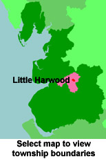
View maps of Little Harwood and places within its boundaries.
View a map of the boundaries of this town/parish.
You can see maps centred on OS grid reference SD693302 (Lat/Lon: 53.767024, -2.466597), Little Harwood which are provided by:
- OpenStreetMap
- Google Maps
- StreetMap (Current Ordnance Survey maps)
- Bing (was Multimap)
- Old Maps Online
- National Library of Scotland (Old Ordnance Survey maps)
- Vision of Britain (Click "Historical units & statistics" for administrative areas.)
- English Jurisdictions in 1851 (Unfortunately the LDS have removed the facility to enable us to specify a starting location, you will need to search yourself on their map.)
- Magic (Geographic information) (Click + on map if it doesn't show)
- GeoHack (Links to on-line maps and location specific services.)
- All places within the same township/parish shown on an Openstreetmap map.
- Nearby townships/parishes shown on an Openstreetmap map.
- Nearby places shown on an Openstreetmap map.
For probate purposes prior to 1858, Little Harwood was in the Archdeaconry of Chester, in the Diocese of Chester. The original Lancashire wills for the Archdeaconry of Chester are held at the Lancashire Record Office.
You can also see Family History Societies covering the nearby area, plotted on a map. This facility is being developed, and is awaiting societies to enter information about the places they cover.