
Hide
Mearley
hide
Hide
hide
Hide
hide
Hide
Hide
MEARLEY, a township in Whalley parish, Lancashire; under Pendle Hill, and within Clitheroe borough, 2 miles ESE of Clitheroe r. station. Acres, 1,280. Real property, £936. Pop., 47. Houses, 7.
John Marius Wilson, Imperial Gazetteer of England and Wales (1870-72)
Hide
Details about the census records, and indexes for Mearley.
The Register Office covering the Mearley area is Ribble Valley.
The National Gazetteer of Great Britain and Ireland - 1868
"MEARLEY, a township in the parish of Whalley, higher division of the hundred of Blackburn, county Lancaster, 2 miles S.E. of Clitheroe railway station. It is a small township, situated at the foot of the Pendle hills."
- Ask for a calculation of the distance from Mearley to another place.
In 1835 Mearley was a township in the parish of Whalley.
View maps of Mearley and places within its boundaries.
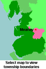
View a map of the boundaries of this town/parish.
You can see maps centred on OS grid reference SD775409 (Lat/Lon: 53.864252, -2.343033), Mearley which are provided by:
- OpenStreetMap
- Google Maps
- StreetMap (Current Ordnance Survey maps)
- Bing (was Multimap)
- Old Maps Online
- National Library of Scotland (Old Ordnance Survey maps)
- Vision of Britain (Click "Historical units & statistics" for administrative areas.)
- English Jurisdictions in 1851 (Unfortunately the LDS have removed the facility to enable us to specify a starting location, you will need to search yourself on their map.)
- Magic (Geographic information) (Click + on map if it doesn't show)
- GeoHack (Links to on-line maps and location specific services.)
- All places within the same township/parish shown on an Openstreetmap map.
- Nearby townships/parishes shown on an Openstreetmap map.
- Nearby places shown on an Openstreetmap map.
For probate purposes prior to 1858, Mearley was in the Archdeaconry of Chester, in the Diocese of Chester. The original Lancashire wills for the Archdeaconry of Chester are held at the Lancashire Record Office.
You can also see Family History Societies covering the nearby area, plotted on a map. This facility is being developed, and is awaiting societies to enter information about the places they cover.