
Hide
Nether Kellet
hide
Hide
hide
Hide
hide
Hide
Hide
KELLET (NETHER), a township in Bolton-le-Sands parish, Lancashire; 5 miles N by E of Lancaster. Acres, 2,018. Real property, £2,659. Pop., 284. Houses, 54. Dunald-Mill-Hole here is a curious stalactitic cavern, forming the commencement of a natural tunnel, which extends nearly 3 miles to the vicinity of Carnforth. A stream turns a mill adjacent to the cavern, and then traverses the tunnel.
John Marius Wilson, Imperial Gazetteer of England and Wales (1870-72)
Hide
| Main Rd Congregational, Nether Kellet |
Details about the census records, and indexes for Nether Kellett.
| Main Rd Congregational, Nether Kellet |
The Register Office covering the Nether Kellet area is Lancaster.
The National Gazetteer of Great Britain and Ireland - 1868
"NETHER KELLET, a township in the parish of Bolton le Moors, hundred of Lonsdale South of the Sands, county Lancaster, 1½ mile from Over Kellet, and 5 miles N. of Lancaster. There are some limestone quarries. In this township is a natural cavern called Donald Mill Hole, at the entrance of which is a mill worked by a stream which runs through a subterranean passage for nearly 3 miles.
- Ask for a calculation of the distance from Nether Kellet to another place.
In 1835 Nether Kellet was a township in the parish of BoltonLeSands.
Information about boundaries and administrative areas is available from A Vision of Britain through time.
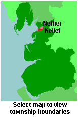
View maps of and places within its boundaries.
View a map of the boundaries of this town/parish.
You can see maps centred on OS grid reference SD516680 (Lat/Lon: 54.105475, -2.741384), Nether Kellet which are provided by:
- OpenStreetMap
- Google Maps
- StreetMap (Current Ordnance Survey maps)
- Bing (was Multimap)
- Old Maps Online
- National Library of Scotland (Old Ordnance Survey maps)
- Vision of Britain (Click "Historical units & statistics" for administrative areas.)
- English Jurisdictions in 1851 (Unfortunately the LDS have removed the facility to enable us to specify a starting location, you will need to search yourself on their map.)
- Magic (Geographic information) (Click + on map if it doesn't show)
- GeoHack (Links to on-line maps and location specific services.)
- All places within the same township/parish shown on an Openstreetmap map.
- Nearby townships/parishes shown on an Openstreetmap map.
- Nearby places shown on an Openstreetmap map.
For probate purposes prior to 1858, Nether Kellet was in the Archdeaconry of Richmond, in the Diocese of Chester. The original Lancashire wills for the Archdeaconry of Richmond are held at the Lancashire Record Office.
- Lancashire Family History & Heraldry Society - Lancaster & Morecambe Branch
- Lancashire Parish Register Society
You can also see Family History Societies covering the nearby area, plotted on a map. This facility is being developed, and is awaiting societies to enter information about the places they cover.