
Hide
Edgeside Lane, Waterfoot Baptist, Newchurch in Rossendale
hide
Hide
Hide
Hide
In 1848, when William Proctor of Burnley and Isaac Stocks of Shore came to live in Waterfoot they set up a meeting place in a cottage in Miller Barn Lane; They were the fore runners of a small band of people known as "General Baptists". This new church did not last long after the Stocks family moved to Bacup, and the room had to be given up. Those that were left behind carried on meeting in a blacksmiths shop at Hollin Bank, Scoutbottom. Though they could not afford the rent for the room they were assisted by the Rev James Maden of Gambleside, who as well as guaranteeing the rent of three shillings a week, also provided a preacher for many months. With this aid the church began to grow and in 1853 it was able to declare its independence.
Eventually a new meeting place was found at the top of Ashworth Lane and though the congregation was slowly building up, it was a constant struggle. By the early 1860s the membership had risen sufficiently to warrant a purpos-built church and the foundation stone was laid on Whit Saturday the 21st May 1864 at a site on Edgeside Lane. The new church, which cost £1,100 to build and a further £220 to equip, held its first service on 26th March 1865. In 1947 when most churchs were finding their congregations dwindling Edgeside Baptist Church were in the enviable position of having to build an extension to the church which opened on 30th November.
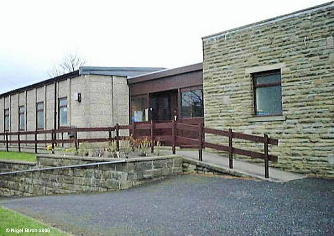
By the late 1970s the church building was suffering from dry rot and high running costs and the decision was made to demolish the church building and to build a new church in its place. The first service in the new church was held on Easter Sunday 1983 and a dedication service was held on Sunday 17th July, and this building is still being used to this day.
This site provides historical information about churches, other places of worship and cemeteries. It has no connection with the churches etc. themselves. For current information you should contact them directly.
- OpenStreetMap
- Google Maps
- StreetMap (Current Ordnance Survey maps)
- Bing (was Multimap)
- Old Maps Online
- National Library of Scotland (Old Ordnance Survey maps)
- Vision of Britain (Click "Historical units & statistics" for administrative areas.)
- English Jurisdictions in 1851 (Unfortunately the LDS have removed the facility to enable us to specify a starting location, you will need to search yourself on their map.)
- Magic (Geographic information) (Click + on map if it doesn't show)
- GeoHack (Links to on-line maps and location specific services.)