
Hide
Oswaldtwistle
hide
Hide
hide
Hide
hide
Hide
Hide
OSWALDTWISTLE, a town, a township, a chapelry, and a sub-district, in Whalley parish and Blackburn district, Lancashire. The town stands on the Leeds and Liverpool canal, and on the East Lancashire section of the Yorkshire and Lancashire railway, contiguous to Church village and r. station, 3 miles E S E of Blackburn; is built chiefly of stone; is supplied with water, from works constructed in 1865; carries on industry in extensive cotton-factories, print-works, and potteries; conducts traffic also in connexion with neighbouring collieries and quarries; and has a post-office under Accrington, a local board of health, a church, two large Church schools used also as chapels of ease, five dissenting chapels, three national schools, two dissenting schools, a temperance library and reading-room, and charities £50. The church was built in 1837; consists of nave and chancel, with a tower; and contains about 800 sittings. The dissenting chapels are Independent, Baptist, Wesleyan, Primitive Methodist, and United Free Methodist. The township contains also the hamlets of Bellthorn, Stanhill, and Knuzden-Brook. Acres, 4,770. Real property, £27,027; of which £4,237 are in mines, and £317 in quarries. Pop. in 1851, 7,654; in 1861, 7,701. Houses, 1,396. The manor belongs to Sir Robert Peel, Bart. Peelfold, where the first Sir Robert Peel spent his early years, is in Knuzden-Brook. Bellthorn House, Stanhill House, Knuzden Hall, and Mount Pleasant are chief re-sidences. Two cotton-factories are at Knuzden-Brook; an Independent chapel is in Bellthorn; and national schools are in Bellthorn and Knuzden-Brook. The chapelry is less extensive than the township, and was constituted in 1840. Pop. in 1861, 6,183. Houses, 1,100. The living is a p. curacy in the diocese of Manchester. Value, £300.* Patrons, Five Trustees. The sub-district comprises the township of Oswaldtwistle and Church. Acres, 5,390. Pop. in 1851, 9,689; in 1861, 12,454. Houses, 2,269.
John Marius Wilson, Imperial Gazetteer of England and Wales (1870-72)
Hide
Local studies information is held at Accrington library.
The monumental incriptions for the Baptist Chapel, New Lane and Immanuel Church have been published by the LFH&HS.
| Chapel St, Belthorn, Independent |
Details about the census records, and indexes for Oswaldtwistle.
| Albert St, Congregational, Oswaldtwistle |
| Chapel St, Belthorn, Independent |
| St James, Oswaldtwistle, Congregational Free Church |
| St Mary, Oswaldtwistle, Roman Catholic |
The Register Office covering the Oswaldtwistle area is Hyndburn and Rossendale.
The National Gazetteer of Great Britain and Ireland - 1868
"OSWALDTWISTLE, a township in the parish of Whalley, lower division of the hundred of Blackburn, county Lancaster, 1 mile from Accrington, its post town, 3½ miles S.E. of Blackburn, and near Church Town station on the East Lancashire railway. The village, which is of large extent, is situated on the Leeds and Liverpool canal. It is lighted with gas, and well supplied with water. The houses are chiefly of stone. A large portion of the inhabitants are employed in the cotton mills and print works. There are also extensive collieries, potteries, and stone quarries. The living is a perpetual curacy in the diocese of Manchester, value £300. The church, dedicated to Emanuel, has a tower containing one bell. The parochial charities produce about £5 per annum. There are National schools for both sexes, also Sunday-schools. The Independents, Wesleyans, Wesleyan Association, Baptists, and Primitive Methodists, have each a place of worship, and the three former have a Sunday-school in connection with their chapels. Sir R. Peel, Bart., is lord of the manor."
- Ask for a calculation of the distance from Oswaldtwistle to another place.
Fiona Hall has made available Oswaltwistle census transcripts for surname HAWORTH 1841-1901 and WALSH, SUDALL, TATTERSALL for some of the other years.
In 1835 Oswaldtwistle was a chapelry and township in the parish of Whalley.
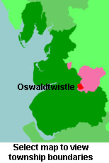
View maps of Oswaldtwistle and places within its boundaries.
View a map of the boundaries of this town/parish.
You can see maps centred on OS grid reference SD738260 (Lat/Lon: 53.730104, -2.398673), Oswaldtwistle which are provided by:
- OpenStreetMap
- Google Maps
- StreetMap (Current Ordnance Survey maps)
- Bing (was Multimap)
- Old Maps Online
- National Library of Scotland (Old Ordnance Survey maps)
- Vision of Britain (Click "Historical units & statistics" for administrative areas.)
- English Jurisdictions in 1851 (Unfortunately the LDS have removed the facility to enable us to specify a starting location, you will need to search yourself on their map.)
- Magic (Geographic information) (Click + on map if it doesn't show)
- GeoHack (Links to on-line maps and location specific services.)
- All places within the same township/parish shown on an Openstreetmap map.
- Nearby townships/parishes shown on an Openstreetmap map.
- Nearby places shown on an Openstreetmap map.
For probate purposes prior to 1858, Oswaldtwistle was in the Archdeaconry of Chester, in the Diocese of Chester. The original Lancashire wills for the Archdeaconry of Chester are held at the Lancashire Record Office.
You can also see Family History Societies covering the nearby area, plotted on a map. This facility is being developed, and is awaiting societies to enter information about the places they cover.