
Hide
Over Darwen
hide
Hide
hide
Hide
hide
Hide
Hide
DARWEN (Over), a town, a township, and three chapelries, in Blackburn parish, Lancashire. The town stands near the Blackburn and Bolton railway, 4 miles S of Blackburn; is a seat of manufacture; and has a post office under Blackburn, a r. station, a market-house, public baths, a mechanics' institute, a lecture-hall, a weekly market, and three annual fairs. The township comprises 5,010 acres. Real property, £39,356; of which £6,082 are in mines, £308 in quarries, and £253 in gas-works. Pop., 16,492. Houses, 2,925. There are great cotton-mills, print and bleach works, paper-works, foundries, and machine-works. The chapelries are St. James, Trinity, and St. John; the first two p. curacies, the third a vicarage. Value of St. James, £240;* of Trinity, £300;* of St. John, £150. Patron of the two first, the Vicar of Blackburn; of St. John, the Rev. P. Graham. St. James, church was built in 1829, Trinity in 1829, St. John's in 1864; the last at a cost of £8, 000. There are another church, four Independent chapels, a Baptist, a Wesleyan of 1865, two other Methodist, and a R. Catholic, a cemetery with three chapels of 1861, and seven public schools.
John Marius Wilson, Imperial Gazetteer of England and Wales (1870-72)
Hide
Darwen Library,
Knott Street,
Darwen
BB3 3BU
| St James, Over Darwen, Church of England |
| St Paul Church of England, Hoddlesden |
| St Peter (formerly Holy Trinity), Over Darwen, Church of England |
| Belgrave Meeting House, Darwen, Independent |
| Lower Chapel Independent, Darwen |
| Pole Lane Independent, Darwen |
| Eastern Cemetery, Darwen |
| Western Cemetery, Darwen |
Details about the census records, and indexes for Over Darwen.
The Register Office covering the Over Darwen area is Blackburn.
The National Gazetteer of Great Britain and Ireland - 1868
"OVER DARWEN, a township and chapelry in the parish of Blackburn, lower division of the hundred of Blackburn, in the county of Lancaster. 4¼, miles S.E. from Blackburn, and 7 from Haslingden. It is situated near the head of the river Darwen, which rises near Rumbles Moor. There are collieries, slate-quarries, print-works, and bleach grounds. The village is lighted with gas, under the provisions of an Act passed in 1839. The living is a perpetual curacy, formerly in the diocese of Chester, now in the dioc, of Manchester, value £200, in the patronage of the Vicar of Blackburn. The church, dedicated to St. James, is a handsome building, erected in 1829. A church dedicated to the Holy Trinity has also been erected. The living is a perpetual curacy, value £74, in the patronage of the Vicar of Blackburn. There are chapels for Wesleyans and others. Fairs are held on the first Thursdays in October and May for cattle and horses, and a pleasure fair on Holy Thursday.
- Ask for a calculation of the distance from Over Darwen to another place.
In 1835 Over Darwen was a chapelry and township in the parish of Blackburn.
Historically, Darwen was (and still is) divided into two districts, originally known as Upper Darwen and Nether or Lower Darwen. Upper Darwen later became Over Darwen and finally just Darwen, while the other remains as Lower Darwen to this day.
In the 1600's the only place of worship in Upper Darwen was the chapelry of St. James', situated on high ground on the eastern flanks of the valley wherein flows the River Darwen and lies the town itself. As the separatist movement within the established church of the middle 1600's spread, Upper Darwen became quite a stronghold and a chapel was built, close to St. James', but in a position slightly lower down the hill. To avoid confusion (little did they realise!!) the two chapels became known as Higher Chapel (St. James') and Lower Chapel (the independent church). Both chapels lay within the Parish of Blackburn, with St. Mary the Virgin as the Parish Church. At that time, the two chapels were restricted to performing baptisms and burials, while marriages could only be performed at St. Mary's, Blackburn. Hence, records quote Darwen as part of the parish of Blackburn, although in reality the town was fiercely independent of it's bigger neighbour (and still is to this day, in spite of the recent re-organisations in local government which has combined the two into "Blackburn with Darwen" or, as the locals prefer, "Darwen with Blackburn"!).
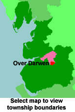
View maps of Over Darwen and places within its boundaries.
View a map of the boundaries of this town/parish.
You can see maps centred on OS grid reference SD699211 (Lat/Lon: 53.685802, -2.456818), Over Darwen which are provided by:
- OpenStreetMap
- Google Maps
- StreetMap (Current Ordnance Survey maps)
- Bing (was Multimap)
- Old Maps Online
- National Library of Scotland (Old Ordnance Survey maps)
- Vision of Britain (Click "Historical units & statistics" for administrative areas.)
- English Jurisdictions in 1851 (Unfortunately the LDS have removed the facility to enable us to specify a starting location, you will need to search yourself on their map.)
- Magic (Geographic information) (Click + on map if it doesn't show)
- GeoHack (Links to on-line maps and location specific services.)
- All places within the same township/parish shown on an Openstreetmap map.
- Nearby townships/parishes shown on an Openstreetmap map.
- Nearby places shown on an Openstreetmap map.
For probate purposes prior to 1858, Over Darwen was in the Archdeaconry of Chester, in the Diocese of Chester. The original Lancashire wills for the Archdeaconry of Chester are held at the Lancashire Record Office.
You can also see Family History Societies covering the nearby area, plotted on a map. This facility is being developed, and is awaiting societies to enter information about the places they cover.