
Hide
Poulton with Fearnhead
hide
Hide
hide
Hide
hide
Hide
Hide
POULTON-WITH-FEARNHEAD, a township in Warrington parish, Lancashire; 2½ miles N E of Warrington r. station. Acres, 1, 233. Real property, £4,087. Pop., 672. Houses, 131. The church of Padgate chapelry, a Wesleyan chapel, and an endowed national school are here.
John Marius Wilson, Imperial Gazetteer of England and Wales (1870-72)
Hide
Local studies information is held at Warrington library.
Details about the census records, and indexes for Poulton with Fearnhead.
The Register Office covering the Poulton with Fearnhead area is Warrington.
The National Gazetteer of Great Britain and Ireland - 1868
"POULTON-WITH-FEARNHEAD, (or Padgate), a township in the parish of Warrington, hundred of West Derby, county Lancaster, 2½ miles N.E. of Warrington, its railway station and post town. The village, which is small, is situated on the old road from Warrington to Bolton, and is chiefly agricultural. The soil is in parts alluvial on sand, and in others clayey. The living is a perpetual curacy in the diocese of Chester, value £120. The church, dedicated to Christ, is new, containing one bell. There is a National school for both sexes, which has an endowment. The Wesleyans, Primitive Methodists, and Roman Catholics have each a place of worship. There is a Sunday-school."
"PADGATE, a village in the parish of Warrington, hundred of West Derby, county Lancaster, 2 miles from Warrington. It is situated near the river Mersey and the Lankey and Bridgwater canals, and has been recently formed into a separate ecclesiastical district. The living is a perpetual curacy in the diocese of Chester, value £120, in the patronage of the Rector of Warrington. The church is a modern structure."
"FEARNHEAD, a township in the parish of Warrington, hundred of West Derby, county palatine Lancaster, 2 miles N.E. of Warrington. This is united with the township of Poulton."
- Ask for a calculation of the distance from Poulton with Fearnhead to another place.
In 1835 Poulton with Fearnhead was a township in the parish of Warrington.
View maps of Fernhead and places within its boundaries.
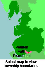
View a map of the boundaries of this town/parish.
You can see maps centred on OS grid reference SJ632899 (Lat/Lon: 53.404786, -2.554439), Poulton with Fearnhead which are provided by:
- OpenStreetMap
- Google Maps
- StreetMap (Current Ordnance Survey maps)
- Bing (was Multimap)
- Old Maps Online
- National Library of Scotland (Old Ordnance Survey maps)
- Vision of Britain (Click "Historical units & statistics" for administrative areas.)
- English Jurisdictions in 1851 (Unfortunately the LDS have removed the facility to enable us to specify a starting location, you will need to search yourself on their map.)
- Magic (Geographic information) (Click + on map if it doesn't show)
- GeoHack (Links to on-line maps and location specific services.)
- All places within the same township/parish shown on an Openstreetmap map.
- Nearby townships/parishes shown on an Openstreetmap map.
- Nearby places shown on an Openstreetmap map.
For probate purposes prior to 1858, Poulton with Fearnhead was in the Archdeaconry of Chester, in the Diocese of Chester. The original Lancashire wills for the Archdeaconry of Chester are held at the Lancashire Record Office.
You can also see Family History Societies covering the nearby area, plotted on a map. This facility is being developed, and is awaiting societies to enter information about the places they cover.