
Hide
Preesall with Hackensall
hide
Hide
hide
Hide
hide
Hide
Hide
PREESALL-WITH-HACKENSALL, a township in Lancaster parish, Lancashire; on Lancaster bay and the river Wyre, opposite Fleetwood. Acres, 3,860; of which 965 are water. Real property, £5,351. Pop., 812. Houses, 180. The manor, with Parrox Hall, belongs to D. H. Elletson, Esq. A cemetery for this township and for Stalmine-with-Stainall, was formed in 1856; and there is an Independent chapel.
John Marius Wilson, Imperial Gazetteer of England and Wales (1870-72)
Hide
| Bethel Congregational, Preesall |
| Cemetery Lane Cemetery, Preesall |
Details about the census records, and indexes for Preesall with Hackensall.
| Bethel Congregational, Preesall |
| Cemetery Lane Cemetery, Preesall |
| St Bernard Roman Catholic, Knott End |
The Register Office covering the Preesall with Hackensall area is Lancaster.
The National Gazetteer of Great Britain and Ireland - 1868
"PREESALL-WITH-HACKENSALL, a township in the parish of Lancaster, hundred of Amounderness, county Lancaster, 7 miles N.E. of Poulton-le-Fylde, and 2 E. of Fleetford. The village, which is of small extent, is situated near the river Wyre, and is wholly agricultural. There is a small endowed school, also a place of worship for the Independents. There is a cemetery, which is used by this and the neighbouring township of Stalmine-with-Stainall. D. H. Elletson, Esq., is lord of the manor."
"HACKENSALL, a township in the parish of Lancaster, hundred of Amounderness, county Lancaster, 8 miles N.W. of Garstang. The village is considerable, and is united with Preesall to form a township."
- Ask for a calculation of the distance from Preesall with Hackensall to another place.
In 1835 Preesall with Hackensall was a township in the parish of Lancaster.
View maps of Preesall and places within its boundaries.
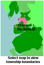
View a map of the boundaries of this town/parish.
You can see maps centred on OS grid reference SD368482 (Lat/Lon: 53.926152, -2.964625), Preesall with Hackensall which are provided by:
- OpenStreetMap
- Google Maps
- StreetMap (Current Ordnance Survey maps)
- Bing (was Multimap)
- Old Maps Online
- National Library of Scotland (Old Ordnance Survey maps)
- Vision of Britain (Click "Historical units & statistics" for administrative areas.)
- English Jurisdictions in 1851 (Unfortunately the LDS have removed the facility to enable us to specify a starting location, you will need to search yourself on their map.)
- Magic (Geographic information) (Click + on map if it doesn't show)
- GeoHack (Links to on-line maps and location specific services.)
- All places within the same township/parish shown on an Openstreetmap map.
- Nearby townships/parishes shown on an Openstreetmap map.
- Nearby places shown on an Openstreetmap map.
For probate purposes prior to 1858, Preesall with Hackensall was in the Archdeaconry of Richmond, in the Diocese of Chester. The original Lancashire wills for the Archdeaconry of Richmond are held at the Lancashire Record Office.
You can also see Family History Societies covering the nearby area, plotted on a map. This facility is being developed, and is awaiting societies to enter information about the places they cover.