
Hide
Scarisbrick
hide
Hide
hide
Hide
hide
Hide
Hide
SCARISBRICK, a village, a township-chapelry, and a sub-district, in Ormskirk parish and district, Lancashire. The village stands on the Leeds and Liverpool canal, 3 miles N W of Ormskirk r. station; and has a post-office under Ormskirk. The chapelry contains also the hamlets of Bescar and Snape-Green. Acres, 8,377. Real property, £13,752; of which £23 are in quarries. Pop., 2,112. Houses, 363. The manor, with S. Hall, belongs to Lady Scarisbrick. The living is annexed to Ormskirk. The church is in the later English style. There are chapels for Wesleyans and Roman Catholics, an endowed school with £18 a year, and charities £19. The sub-district contains also Burscough township, and comprises 13,336 acres. Pop., 4,573. Houses, 841.
John Marius Wilson, Imperial Gazetteer of England and Wales (1870-72)
Hide
Local studies information is held at Ormskirk and Skelmersdale libraries.
| St Mary / St Elizabeth, Scarisbrick, Roman Catholic |
Details about the census records, and indexes for Scarisbrick.
| Scarisbrick Drummersdale Mission Welsh Presbyterian Lancashire |
| St Mary / St Elizabeth, Scarisbrick, Roman Catholic |
The Register Office covering the Scarisbrick area is West Lancashire.
The National Gazetteer of Great Britain and Ireland - 1868
"SCARISBRICK, a township in the parish of Ormskirk, hundred of West Derby, county Lancaster, 3 miles N.W. of Ormskirk, its post town, and near the Burscough railway station. The village, which is large, is situated on the Leeds canal. The township includes a part of Martin-Mere, which was drained in 1799 by Mr. Eccleston. The soil is of a loamy and sandy nature, with a subsoil of sand. There are brick kilns. The living is a curacy annexed to the vicarage of Ormskirk, in the diocese of Chester. The church is dedicated to St. Mark. The interior of the church contains a carved pulpit. The parochial charities produce about £18 per annum. There is a National school for boys, also British and Foreign schools. The Wesleyans and Roman Catholics have each a place of worship. Among the principal seats are Dummersdale, Gorsuch Hall, Biglake, Heskin Hall, Hurlston Hall, Fairlake, and Scarisbrick Hall-which last is an ancient mansion situated in a park; the hall contains some pictures by Martin and other masters, and is now the seat of C. Scarisbrick, Esq., who is lord of the manor and holds a court-leet annually."
- Ask for a calculation of the distance from Scarisbrick to another place.
In 1835 Scarisbrick was a township in the parish of Ormskirk.
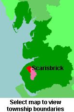
View maps of Scarisbrick and places within its boundaries.
View a map of the boundaries of this town/parish.
You can see maps centred on OS grid reference SD389131 (Lat/Lon: 53.610991, -2.924483), Scarisbrick which are provided by:
- OpenStreetMap
- Google Maps
- StreetMap (Current Ordnance Survey maps)
- Bing (was Multimap)
- Old Maps Online
- National Library of Scotland (Old Ordnance Survey maps)
- Vision of Britain (Click "Historical units & statistics" for administrative areas.)
- English Jurisdictions in 1851 (Unfortunately the LDS have removed the facility to enable us to specify a starting location, you will need to search yourself on their map.)
- Magic (Geographic information) (Click + on map if it doesn't show)
- GeoHack (Links to on-line maps and location specific services.)
- All places within the same township/parish shown on an Openstreetmap map.
- Nearby townships/parishes shown on an Openstreetmap map.
- Nearby places shown on an Openstreetmap map.
For probate purposes prior to 1858, Scarisbrick was in the Archdeaconry of Chester, in the Diocese of Chester. The original Lancashire wills for the Archdeaconry of Chester are held at the Lancashire Record Office.
You can also see Family History Societies covering the nearby area, plotted on a map. This facility is being developed, and is awaiting societies to enter information about the places they cover.