
Hide
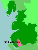
St Helens
hide
Hide
hide
Hide
hide
Hide
Hide
HELENS (ST.), a town, a parochial chapelry, and a sub-district in Prescot parish and district, Lancashire. The town stands on Sankey brook, the Sankey canal, and the St. Helens railway, 3 miles NE by E of Prescot, and 12 ENE of Liverpool; and comprises parts of the townships of Eccleston, Windle, and Parr. The county lunatic asylum here, is within Sutton township, and, at the census of 1861, had 704 inmates. The town has a head post office, a railway station with telegraph, two banking offices, and four chief inns; is governed by a mayor, aldermen, and town council; is a seat of petty sessions, and a county court; and publishes three weekly newspapers. A weekly market is held on Saturday; and fairs are held on the Monday and Tuesday after Easter week, and on the Friday and Saturday after 8 Sept. A very celebrated manufacture of crown, sheet, and plate glass, said to be the greatest in the world, is carried on. There are also manufactures of flint glass, glass bottles, and watch movements; several very extensive chemical works; oil and grease works; copper works; iron and brass foundries; a brewery; and coarse earthenware potteries. A considerable trade in coal likewise is carried on from neighbouring collieries. Pop. of the town, in 1851, 14,866; in 1861, 18,396. Houses, 3,146. The chapelry is more extensive than the town, and was constituted in 1852. Pop. in 1861, 20,176. Houses, 3,577. The living is a vicarage in the diocese of Chester. Value, £500.* Patrons, Trustees. Holy Trinity and St. Thomas also are vicarages. Value of the former, £300; * of the latter, £300.* Patron of H. T., the Vicar of St. Helens; of St. T., Trustees. The sub-district contains the townships of Windle, Parr, and Sutton, and part of the township of Eccleston. Pop. in 1851, 25,020; in 1861, 37,961. Houses, 6,539. more ...
John Marius Wilson, Imperial Gazetteer of England and Wales (1870-72)
Hide
St. Helens Local History and Archives Library,
Central Library,
Gamble Institute,
Victoria Square,
St Helens,
Merseyside
WA10 1DY
Tel: 01744 456989, 456956, 456954
Fax: 01744 20836
Their Tracing your Family Tree leaflet gives basic information about using the library facilities.
N.B. The library does not have the facilities to undertake research for you. You will have to visit in person, or employ a researcher.
Eileen Williams has provided a list of graveyards in the St. Helens area.
| Ormskirk St, St Helens, Independent |
| Hard Lane Cemetery, St Helens |
| St Mary, Lowe House,St Helens, Roman Catholic |
| Windleshaw Chantry, St Helens, Roman Catholic |
| Raven St, St Helens, Society of Friends |
Details about the census records, and indexes for St Helens.
The Register Office covering the St Helens area is St Helens.
The National Gazetteer of Great Britain and Ireland - 1868
"ST. HELEN'S, a large market and manufacturing town in the townships of Windle_and_Sutton, Eccleston_and_Parry, and the parish of Prescot, hundred of West Derby, county Lancaster, 3 miles N.E. of Prescot, and 48 S. of Lancaster. It is a station on the London and North-Western railway, the St. Helen's junction being about 2 miles from the town; there is also water communication by the Sankey Brook canal. The town, which is one of large and increasing commerce, is very irregularly built, and covers a large extent of ground, being entirely of modern date. The market-place forms a square in the centre of the town, and on one side stands the townhall, a modern building. The inhabitants are chiefly engaged in the neighbouring collieries and in the extensive glass manufactories, that at Ravenhead, in the township of Sutton, being the largest plate glass manufactory in the world. There are also potteries, breweries, and extensive chemical works. In 1830 extensive works for smelting copper were established by the Bolivar Mining Association, and similar works were subsequently erected by the British and Foreign Copper Company. The living is a perpetual curacy in the diocese of Chester, value £450, in the patronage of trustees. There are three churches, two Roman Catholic chapels, and chapels belonging to the Independents and Methodists, and a school with an ample endowment founded by Mrs. Cowley. Market day is Saturday. Fairs are held on Monday and Tuesday after Easter week, and Friday and Saturday after the 8th September.
- Ask for a calculation of the distance from St Helens to another place.
View maps of St Helens and places within its boundaries.
View a map of the boundaries of this town/parish.
You can see maps centred on OS grid reference SJ514955 (Lat/Lon: 53.45402, -2.733536), St Helens which are provided by:
- OpenStreetMap
- Google Maps
- StreetMap (Current Ordnance Survey maps)
- Bing (was Multimap)
- Old Maps Online
- National Library of Scotland (Old Ordnance Survey maps)
- Vision of Britain (Click "Historical units & statistics" for administrative areas.)
- English Jurisdictions in 1851 (Unfortunately the LDS have removed the facility to enable us to specify a starting location, you will need to search yourself on their map.)
- Magic (Geographic information) (Click + on map if it doesn't show)
- GeoHack (Links to on-line maps and location specific services.)
- All places within the same township/parish shown on an Openstreetmap map.
- Nearby townships/parishes shown on an Openstreetmap map.
- Nearby places shown on an Openstreetmap map.
For probate purposes prior to 1858, St Helens was in the Archdeaconry of Chester, in the Diocese of Chester. The original Lancashire wills for the Archdeaconry of Chester are held at the Lancashire Record Office.
You can also see Family History Societies covering the nearby area, plotted on a map. This facility is being developed, and is awaiting societies to enter information about the places they cover.