
Hide
Tockholes
hide
Hide
hide
Hide
hide
Hide
Hide
TOCKHOLES, a township and a chapelry in Blackburn parish, Lancashire. The township lies 3 miles SSW of Blackburn r. station. Acres, 2,050. Real property, £2,546. Pop. in 1851, 939; in 1861, 820. Houses, 164. The manor belongs to E. Shorrock, Esq. Two skirmishes occurred here in the civil wars of Charles I. The chapelry was constituted in 1842. Post town, Blackburn. Pop. in 1861, 2,542. Houses, 504. The living is a p. curacy in the diocese of Manchester. Value, £160. Patron, the Vicar of Blackburn. The church was rebuilt in 1833. There are an Independent chapel and two national schools.
John Marius Wilson, Imperial Gazetteer of England and Wales (1870-72)
Hide
Local studies information is held at Blackburn library.
| Bethesda, Tockholes, Independent |
| Independent Chapel, Tockholes |
Details about the census records, and indexes for Tockholes.
| Bethesda, Tockholes, Independent |
| Independent Chapel, Tockholes |
The Register Office covering the Tockholes area is Blackburn.
The National Gazetteer of Great Britain and Ireland - 1868
"TOCKHOLES, a township and chapelry in the parish and hundred of Blackburn, county Lancaster, 3 miles S.W. of Blackburn, its post town, and 7 from Chorley. The village is situated near the Leeds and Liverpool canal, and the road from Blackburn to Manchester. In the valley of the Raddlesworth rivulet the soil is principally marl, but a considerable portion of the upland is in moorland. Many of the inhabitants are employed in the weaving of cotton and in the print-works. The living is a perpetual curacy in the diocese of Manchester, value £150, in the patronage of the Vicar of Blackburn. The church, dedicated to St. Michael, was rebuilt in 1833. The parochial charities produce about £1 per annum. There is a National school, at which a Sunday-school is also held. The Independents have a chapel. The representatives of the late E. Shorrock, Esq., are lords oft] a manor. It is supposed to have been the scene of a skirmish between the royalists and parliamentarians in the reign of Charles I., from the number of cannon-balls found here."
- Ask for a calculation of the distance from Tockholes to another place.
In 1835 Tockholes was a chapelry and township in the parish of Blackburn.
View maps of Tockholes and places within its boundaries.
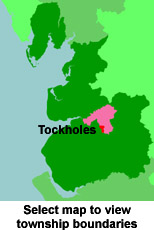
View a map of the boundaries of this town/parish.
You can see maps centred on OS grid reference SD660216 (Lat/Lon: 53.689427, -2.516658), Tockholes which are provided by:
- OpenStreetMap
- Google Maps
- StreetMap (Current Ordnance Survey maps)
- Bing (was Multimap)
- Old Maps Online
- National Library of Scotland (Old Ordnance Survey maps)
- Vision of Britain (Click "Historical units & statistics" for administrative areas.)
- English Jurisdictions in 1851 (Unfortunately the LDS have removed the facility to enable us to specify a starting location, you will need to search yourself on their map.)
- Magic (Geographic information) (Click + on map if it doesn't show)
- GeoHack (Links to on-line maps and location specific services.)
- All places within the same township/parish shown on an Openstreetmap map.
- Nearby townships/parishes shown on an Openstreetmap map.
- Nearby places shown on an Openstreetmap map.
For probate purposes prior to 1858, Tockholes was in the Archdeaconry of Chester, in the Diocese of Chester. The original Lancashire wills for the Archdeaconry of Chester are held at the Lancashire Record Office.
You can also see Family History Societies covering the nearby area, plotted on a map. This facility is being developed, and is awaiting societies to enter information about the places they cover.