
Hide
Tottington Higher End
hide
Hide
hide
Hide
hide
Hide
Hide
TOTTINGTON-HIGHER-END, a township in Bury parish, Lancashire; on the Lancashire and Yorkshire railway, 3 miles S of Haslingden. It contains the r. stations of Stubbins and Erwood-Bridge, the village of Edenfield, and several hamlets. Acres, 3,686. Real property, £13,330; of which £422 are in quarries, and £24 in mines. Pop. in 1851, 2,958; in 1861, 3,726. Houses, 699. There are a large factory, print-works, a paper-mill, and a Primitive Methodist chapel.
John Marius Wilson, Imperial Gazetteer of England and Wales (1870-72)
Hide
Local studies information is held at Bury library.
| Bolton Rd North, Stubbins, Congregational |
Details about the census records, and indexes for Tottington Higher End.
| Bolton Rd North, Stubbins, Congregational |
The Register Office covering the Tottington Higher End area is Hyndburn & Rossendale.
Information about Edenfield provided by the Edenfield Genealogical Society (USA).
The National Gazetteer of Great Britain and Ireland - 1868
"EDENFIELD, (or Enfield), a chapelry in the parish of Bury, hundred of Salford, county palatine of Lancaster, 3 miles S. of Haslingden, and 6 N. of Bury, its post town. The Rosendale railway passes through the place. There are several stone-quarries, and cotton and woollen goods are extensively manufactured. The living is a curacy in the diocese of Manchester, value £150, in the patronage of the Rector of Bury. The church was rebuilt at the close of the last century, and is a commodious edifice, lighted with gas. The Wesleyans and Primitive Methodists have each a chapel, and there are endowed National and Sunday-schools. In the vicinity are several handsome residences.
"TOTTINGTON HIGHER END, a township in the parish of Bury, hundred of Salford, county Lancaster, 3½ miles N.W. of Bury, its post town, and 1 mile N. of Ramsbottom. It has stations at Stubbing and Ewood Bridge, on the East Lancashire railway. The village is situated near the railway. Some of the inhabitants are employed in the cotton mills. The township includes the village of Edenfield. The living is a perpetual curacy in the diocese of Manchester, value £150, in the patronage of the Rector of Bury.
"STUBBINS, a hamlet in the parish of Bury, and the ecclesiastical district of Ramsbottom, county Lancaster, 4½ miles from Bury by the Manchester, Bury, and Bacup branch of the Lancashire and Yorkshire railway, on which it is a station."
"FOE BANK, a village in the township of Higher Tottington, county palatine Lancaster, 6 miles N. of Bury."
John Marius Wilson, Imperial Gazetteer of England and Wales - 1870-2
- Ask for a calculation of the distance from Tottington Higher End to another place.
In 1835 Tottington Higher End was a township in the parish of Bury.
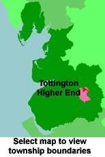
View maps of Tottington Higher End and places within its boundaries.
View a map of the boundaries of this town/parish.
You can see maps centred on OS grid reference SD805198 (Lat/Lon: 53.67406, -2.296159), Tottington Higher End which are provided by:
- OpenStreetMap
- Google Maps
- StreetMap (Current Ordnance Survey maps)
- Bing (was Multimap)
- Old Maps Online
- National Library of Scotland (Old Ordnance Survey maps)
- Vision of Britain (Click "Historical units & statistics" for administrative areas.)
- English Jurisdictions in 1851 (Unfortunately the LDS have removed the facility to enable us to specify a starting location, you will need to search yourself on their map.)
- Magic (Geographic information) (Click + on map if it doesn't show)
- GeoHack (Links to on-line maps and location specific services.)
- All places within the same township/parish shown on an Openstreetmap map.
- Nearby townships/parishes shown on an Openstreetmap map.
- Nearby places shown on an Openstreetmap map.
For probate purposes prior to 1858, Tottington Higher End was in the Archdeaconry of Chester, in the Diocese of Chester. The original Lancashire wills for the Archdeaconry of Chester are held at the Lancashire Record Office.
You can also see Family History Societies covering the nearby area, plotted on a map. This facility is being developed, and is awaiting societies to enter information about the places they cover.