
Hide
Trawden
hide
Hide
hide
Hide
hide
Hide
Hide
TRAWDEN, a village, a township, and a chapelry, in Whalley parish, Lancashire. The village stands 2¼ miles ESE of Colne r. station, and has a post-office under Colne. The township includes Winewall hamlet; and comprises 2,510 acres. Real property, £6,687. Pop. in 1851, 2,601. in 1861, 2,087. Houses, 426. The decrease of pop. was caused by scarcity of employment for hand-loom weavers. The property is much subdivided T. House is the seat of Mrs. Pilling. The chapelry was constituted in 1845, and is less extensive than the township. Pop., 1,516. Houses, 309. The living is a vicarage in the diocese of Manchester. Value, £150. Patron, alternately the Crown and the Bishop. The church was built in 1845. There are three dissenting chapels, and a national school.
John Marius Wilson, Imperial Gazetteer of England and Wales (1870-72)
Hide
Local studies information is held at Colne library.
| Bethel, Trawden, Primitive Methodist |
| Ridge Colne, Trawden, Primitive Methodist |
| Skipton Rd Wesleyan Methodist, Trawden |
| Mire Ridge, Trawden, Society of Friends |
Details about the census records, and indexes for Trawden.
| Bethel, Trawden, Primitive Methodist |
| Ridge Colne, Trawden, Primitive Methodist |
| Skipton Rd Wesleyan Methodist, Trawden |
| Zion Independent Methodist, Trawden |
| St Ursula Roman Catholic, Cotton Tree |
| Mire Ridge, Trawden, Society of Friends |
The Register Office covering the Trawden area is Burnley and Pendle.
The National Gazetteer of Great Britain and Ireland - 1868
"TRAWDEN, a township in the parish of Whalley, higher division of Blackburn hundred, county Lancaster, 2 miles S.E. of Colne, and 6 from Burnley, its post town. The inhabitants are chiefly employed in manufactures similar to those carried on in the neighbouring towns and villages. The township includes the hamlet of Winewall, and was once forest. The soil consists of clay and rock, but the greater part is now under cultivation. The living is a perpetual curacy in the diocese of Manchester, value £150, in the patronage of the crown and bishop alternately. The church is dedicated to St. Mary. There is a National school for both sexes, at which a Sunday-school is also held. The Wesleyans, Primitive Methodists, and Inghamites have chapels. The Duke of Buccleuch is lord of the manor."
"WINE WALL, a hamlet in the township of Trawden Forest, parish of Whalley, county Lancaster, 2 miles S.E. of Colne."
- Ask for a calculation of the distance from Trawden to another place.
In 1835 Trawden was a township in the parish of Whalley.
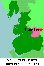
View maps of Trawden and places within its boundaries.
View a map of the boundaries of this town/parish.
You can see maps centred on OS grid reference SD933375 (Lat/Lon: 53.833306, -2.103914), Trawden which are provided by:
- OpenStreetMap
- Google Maps
- StreetMap (Current Ordnance Survey maps)
- Bing (was Multimap)
- Old Maps Online
- National Library of Scotland (Old Ordnance Survey maps)
- Vision of Britain (Click "Historical units & statistics" for administrative areas.)
- English Jurisdictions in 1851 (Unfortunately the LDS have removed the facility to enable us to specify a starting location, you will need to search yourself on their map.)
- Magic (Geographic information) (Click + on map if it doesn't show)
- GeoHack (Links to on-line maps and location specific services.)
- All places within the same township/parish shown on an Openstreetmap map.
- Nearby townships/parishes shown on an Openstreetmap map.
- Nearby places shown on an Openstreetmap map.
For probate purposes prior to 1858, Trawden was in the Archdeaconry of Chester, in the Diocese of Chester. The original Lancashire wills for the Archdeaconry of Chester are held at the Lancashire Record Office.
You can also see Family History Societies covering the nearby area, plotted on a map. This facility is being developed, and is awaiting societies to enter information about the places they cover.