
Hide
Treales, Roseacre & Wharles
hide
Hide
hide
Hide
hide
Hide
Hide
TREALS, a township-chapelry, with three hamlets, in Kirkham parish, Lancashire; near Kirkham r. station. Post town, Kirkham, under Preston. Acres, 4,015. Real property, £5,321. Pop., 632. Houses, 120. The manor belongs to the Earl of Derby. The living is a p. curacy in the diocese of Manchester. Value, £100. Patron, the Vicar of Kirkham. The church was built in 1856; the parsonage, in 1863. There are an endowed school, and charities £10.
John Marius Wilson, Imperial Gazetteer of England and Wales (1870-72)
Hide
Local studies information is held at Kirkham library.
Details about the census records, and indexes for Treales, Roseacre and Wharles.
The Register Office covering the Treales, Wharles and Roseacre area is Blackpool & Fylde.
The National Gazetteer of Great Britain and Ireland - 1868
"TREALES, a township in the parish of Kirkham, hundred of Amounderness, county Lancaster, 1 mile N.E. of Kirkham, its post town. The village, which is considerable, is situated on the Preston railway. The soil is heavy. The township includes the hamlets of Roseacre and Wharles. The living is a perpetual curacy in the diocese of Manchester, value £100, in the patronage of the Vicar of Kirkham. The church, dedicated to Christ, was built in 1855 at the expense of the Earl of Derby, who is lord of the manor and principal landowner. The parochial charities produce about £10 per annum."
"WHARLES, a township in the parish of Kirkham, hundred of Amounderness, county Lancaster, 3 miles N.E. of Kirkham. It includes the hamlets of Treales and Roseacre."
"ROSEACRE, a hamlet in the parish of Kirkham, hundred of Amounderness, county Lancaster, 3½ miles N.E. of Kirkham. It is in conjunction with Treales and Wharles to form a township."
- Ask for a calculation of the distance from Treales, Roseacre & Wharles to another place.
In 1835 Treales, Wharles and Roseacre was a township in the parish of Kirkham.
View maps of Treales and places within its boundaries.
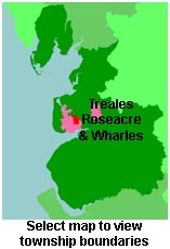
View a map of the boundaries of this town/parish.
You can see maps centred on OS grid reference SD442349 (Lat/Lon: 53.807309, -2.849327), Treales, Roseacre & Wharles which are provided by:
- OpenStreetMap
- Google Maps
- StreetMap (Current Ordnance Survey maps)
- Bing (was Multimap)
- Old Maps Online
- National Library of Scotland (Old Ordnance Survey maps)
- Vision of Britain (Click "Historical units & statistics" for administrative areas.)
- English Jurisdictions in 1851 (Unfortunately the LDS have removed the facility to enable us to specify a starting location, you will need to search yourself on their map.)
- Magic (Geographic information) (Click + on map if it doesn't show)
- GeoHack (Links to on-line maps and location specific services.)
- All places within the same township/parish shown on an Openstreetmap map.
- Nearby townships/parishes shown on an Openstreetmap map.
- Nearby places shown on an Openstreetmap map.
For probate purposes prior to 1858, Treales, Wharles and Roseacre was in the Archdeaconry of Richmond, in the Diocese of Chester. The original Lancashire wills for the Archdeaconry of Richmond are held at the Lancashire Record Office.
You can also see Family History Societies covering the nearby area, plotted on a map. This facility is being developed, and is awaiting societies to enter information about the places they cover.