
Hide
Tunstall
hide
Hide
hide
Hide
hide
Hide
Hide
Tunstal, par. and township, N. Lancashire, near the confluence of the Lune and the Greta, 3 miles S. of Kirkby Lonsdale - par., 9360 ac., pop. 693; township, 1076 ac., pop. 104; P.O.
John Bartholomew, Gazetteer of the British Isles (1887)
Hide
Local studies information is held at Lancaster library.
The following books contain useful information about the history of Tunstall and the surrounding area.
- The Church and Parish of Tunstall by Sara Mason, December 1994. Contact John Moffitt jamtunstal[at]aol[dot]com if you want to obtain a copy.
Details about the census records, and indexes for Tunstall.
The Register Office covering the Tunstall area is Lancaster.
The National Gazetteer of Great Britain and Ireland - 1868
"TUNSTALL, a parish in the hundred of Lonsdale South of the Sands, county Lancaster, 4 miles N.E. of Hornby railway station, and 3½ S. of Kirkby-Lonsdale, its post town. It is situated at the confluence of the rivers Greta and Lune, and contains the townships of Leck, Tunstall, Burrow, and Cantfield. The living is a vicarage in the diocese of Manchester, value £332. The church, dedicated to St. John the Baptist, was restored in 1850. The register dates from 1620. There is also the district church of Leck, the living of which is a perpetual curacy, value £80. There is an endowed school. Thurlow Castle and Burrow Hall are the principal residences. It. T. North, Esq., is lord of the manor."
- Ask for a calculation of the distance from Tunstall to another place.
In 1835 the parish of Tunstall contained the townships of Tunstall, Burrow with Burrow, Leck, and Cantsfield.
View maps of Tunstall and places within its boundaries.
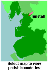
View a map of the boundaries of this town/parish.
You can see maps centred on OS grid reference SD615738 (Lat/Lon: 54.158812, -2.590719), Tunstall which are provided by:
- OpenStreetMap
- Google Maps
- StreetMap (Current Ordnance Survey maps)
- Bing (was Multimap)
- Old Maps Online
- National Library of Scotland (Old Ordnance Survey maps)
- Vision of Britain (Click "Historical units & statistics" for administrative areas.)
- English Jurisdictions in 1851 (Unfortunately the LDS have removed the facility to enable us to specify a starting location, you will need to search yourself on their map.)
- Magic (Geographic information) (Click + on map if it doesn't show)
- GeoHack (Links to on-line maps and location specific services.)
- All places within the same township/parish shown on an Openstreetmap map.
- Nearby townships/parishes shown on an Openstreetmap map.
- Nearby places shown on an Openstreetmap map.
For probate purposes prior to 1858, Tunstall was in the Archdeaconry of Richmond, in the Diocese of Chester. The original Lancashire wills for the Archdeaconry of Richmond are held at the Lancashire Record Office.
You can also see Family History Societies covering the nearby area, plotted on a map. This facility is being developed, and is awaiting societies to enter information about the places they cover.