
Hide
Whiston
hide
Hide
hide
Hide
hide
Hide
Hide
WHISTON, a township in Prescot parish, Lancashire; on the Liverpool and Manchester railway, 1 mile S of Prescot. It has a post-office under Prescot; and it contains Prescot workhouse. Acres, 1,793. Real property, £10,867; of which £4,381 are in mines, and £135 in quarries. Pop. in 1851, 1,825; in 1861, 1,727, of whom 155 were in the workhouse. Houses, 318. A church was built here in 1865, at a cost of about £6,000; and is in the early English style, with tower and spire, 150 feet high. There are also a Methodist chapel and a national school.
John Marius Wilson, Imperial Gazetteer of England and Wales (1870-72)
Hide
Details about the census records, and indexes for Whiston.
The Register Office covering the Whiston area is Knowsley.
The National Gazetteer of Great Britain and Ireland - 1868
"WHISTON, a township in the parish of Prescot, hundred of West Derby, county Lancaster, 1 mile S. of Prescot, of which it is a suburb, and contains the Union poorhouse. The Liverpool and Manchester railway passes through the township by an inclined plane. There are extensive collieries."
- Ask for a calculation of the distance from Whiston to another place.
In 1835 Whiston was a township in the parish of Prescot.
Some information about the history of Whiston.
View maps of Whiston and places within its boundaries.
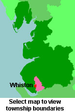
View a map of the boundaries of this town/parish.
You can see maps centred on OS grid reference SJ471910 (Lat/Lon: 53.413135, -2.797748), Whiston which are provided by:
- OpenStreetMap
- Google Maps
- StreetMap (Current Ordnance Survey maps)
- Bing (was Multimap)
- Old Maps Online
- National Library of Scotland (Old Ordnance Survey maps)
- Vision of Britain (Click "Historical units & statistics" for administrative areas.)
- English Jurisdictions in 1851 (Unfortunately the LDS have removed the facility to enable us to specify a starting location, you will need to search yourself on their map.)
- Magic (Geographic information) (Click + on map if it doesn't show)
- GeoHack (Links to on-line maps and location specific services.)
- All places within the same township/parish shown on an Openstreetmap map.
- Nearby townships/parishes shown on an Openstreetmap map.
- Nearby places shown on an Openstreetmap map.
For probate purposes prior to 1858, Whiston was in the Archdeaconry of Chester, in the Diocese of Chester. The original Lancashire wills for the Archdeaconry of Chester are held at the Lancashire Record Office.
You can also see Family History Societies covering the nearby area, plotted on a map. This facility is being developed, and is awaiting societies to enter information about the places they cover.