
Hide
Wray with Botton
hide
Hide
hide
Hide
hide
Hide
Hide
WRAY, a village, a township, a chapelry, and a sub-district, in Lancaster district, Lancashire. The village stands 1 mile ESE of Hornby r. station, and 10 NE of Lancaster; and has a post-office under Lancaster, and cattle fairs on Shrove Tuesday and 30 April. The township includes Botton hamlet, and comprises 6,506 acres. Real property, £4,072; of which £40 are in mines. Pop., 797. Houses, 154. The property is subdivided. The chapelry was constituted in 1842; and is in Melling parish. Pop., 878. Houses, 168. The living is a vicarage in the diocese of Manchester. Value, £60.* Patrons, Trustees. The church was built in 1840. There are two Methodist chapels, a free school, and a subscription library. The sub-district contains six townships of Melling parish, and all Tatham. Acres, 28,953. Pop., 2,270. Houses, 447.
John Marius Wilson, Imperial Gazetteer of England and Wales (1870-72)
Hide
Local studies information is held at Lancaster library.
| Holy Trinity Church of England, Wray |
Details about the census records, and indexes for Wray.
| Holy Trinity Church of England, Wray |
| Hornby Rd Society of Friends, Wray |
The Register Office covering the Wray area is Lancaster.
The National Gazetteer of Great Britain and Ireland - 1868
"WRAY, a township and ecclesiastical district in the parish of Melling, hundred of Lonsdale South of the Sands, county Lancaster, 10 miles N.E. of Lancaster, and 1 mile from Hornby railway station; there is also a station on the Lytham branch of the Lancashire and Yorkshire railway at Wray Green. (The gazetteer has got this wrong, Wrea Green is a township in the parish of Kirkham 30 miles away). The township includes the hamlet of Botton. The village is situated on the junction of the two small streams, Hindburn and Roeburn, and contains a silk mill and a manufactory. The living is a perpetual curacy, value £50, in the patronage of trustees. The church is dedicated to the Holy Trinity. Fairs are held on Shrove Tuesday and 30th April for cattle."
"BOTTON, a hamlet in the parish of Melling, and hundred of Lonsdale South of the Sands, in the county of Lancaster, 10 miles N.E. of Lancaster. It is situated near the river Hindburn and the Lancashire and Yorkshire railway. The inhabitants are chiefly engaged in the silk mills and nail manufacture."
- Ask for a calculation of the distance from Wray with Botton to another place.
In 1835 Wray with Botton was a township in the parish of Melling.
View maps of Wray and places within its boundaries.
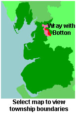
View a map of the boundaries of this town/parish.
You can see maps centred on OS grid reference SD632637 (Lat/Lon: 54.067804, -2.563548), Wray with Botton which are provided by:
- OpenStreetMap
- Google Maps
- StreetMap (Current Ordnance Survey maps)
- Bing (was Multimap)
- Old Maps Online
- National Library of Scotland (Old Ordnance Survey maps)
- Vision of Britain (Click "Historical units & statistics" for administrative areas.)
- English Jurisdictions in 1851 (Unfortunately the LDS have removed the facility to enable us to specify a starting location, you will need to search yourself on their map.)
- Magic (Geographic information) (Click + on map if it doesn't show)
- GeoHack (Links to on-line maps and location specific services.)
- All places within the same township/parish shown on an Openstreetmap map.
- Nearby townships/parishes shown on an Openstreetmap map.
- Nearby places shown on an Openstreetmap map.
For probate purposes prior to 1858, Wray was in the Archdeaconry of Richmond, in the Diocese of Chester. The original Lancashire wills for the Archdeaconry of Richmond are held at the Lancashire Record Office.
You can also see Family History Societies covering the nearby area, plotted on a map. This facility is being developed, and is awaiting societies to enter information about the places they cover.