
Hide
Amber Hill
hide
Hide
hide
Hide
hide
Hide
Hide
Hide
The Library at Boston will prove useful in your research.
- The parish was in the Swineshead sub-district of the Boston Registration District.
- In 1896, the Swineshead sub-district was merged into the Kirton sub-district.
- We have a handful of 1891 census names in a text file. Your additions are welcome.
- Check our Census Resource page for county-wide resources.
- The table below gives census piece numbers, where known:
| Census Year | Piece No. |
|---|---|
| 1871 | R.G. 10 / 3346 |
| 1891 | R.G. 12 / 2576 |
- The Anglican church is dedicated to Saint John the Baptist.
- The church was built in 1867.
- There is a photograph of St. John's Church on the Wendy Parkinson web site under "Yet More Lincolnshire".
- Here is a photograph St. John the Baptist's Church supplied by Ron COLE (who retains the copyright):
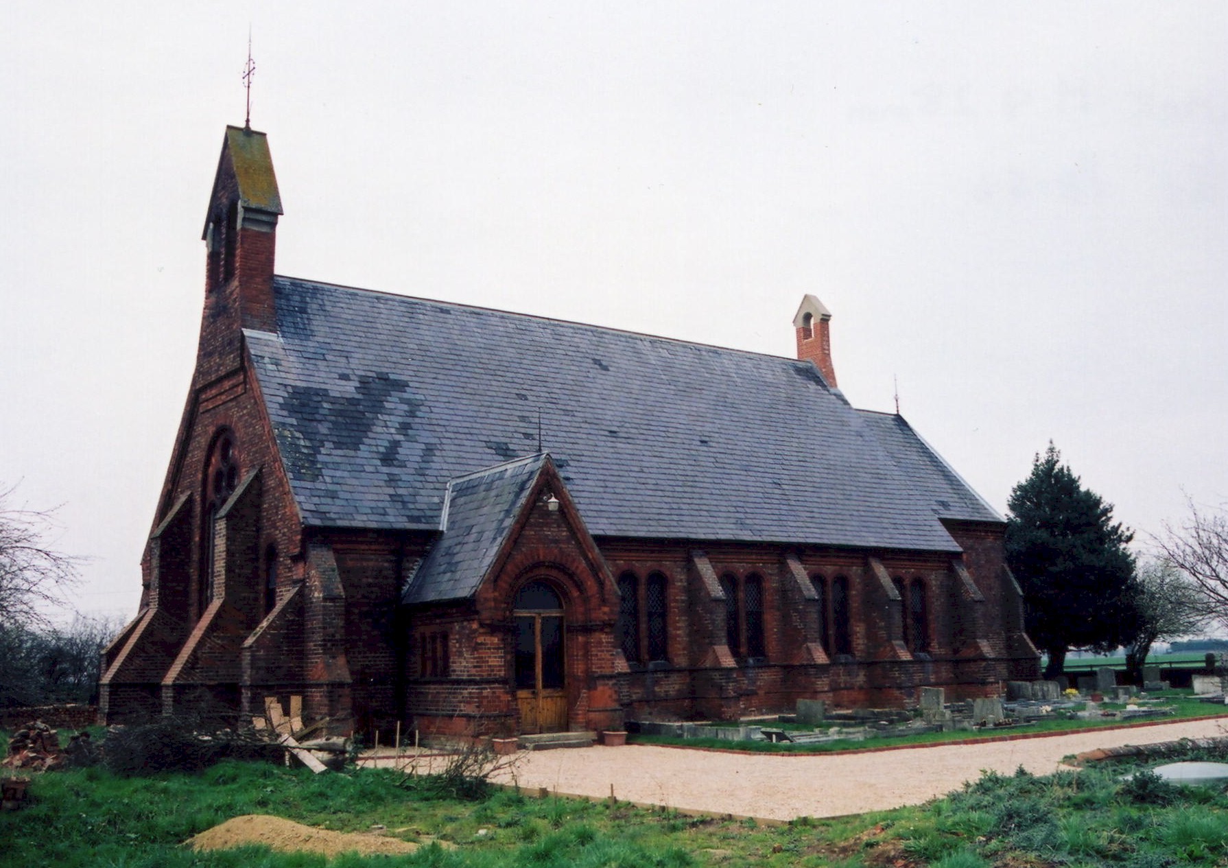
- St. John Church was declared redundant by the Diocese of Lincoln in February, 1995. In April, 1998, it was sold for residential use. The churchyard continues to be used for burials.
- The church remains a Grade 2 listed historical building.
- The LFHS has published several indexes for the Holland West Deanery to make your search easier.
- The Wesleyan Methodist's had a chapel built here in 1846, rebuilt in 1877. The Methodist chapel has since closed. The Primitive Methodists built a chapel here in 1892.
- Find out more about these chapels at our non-conformist religions page.
- Check our Church Records page for county-wide resources.
- The parish was in the Swineshead sub-district of the Boston Registration District.
- In 1896, the Swineshead sub-district was merged into the Kirton sub-district.
- Check our Civil Registration page for sources and background on Civil Registration which started in July, 1837.
Amber Hill has been described as a "gravel field of 30 acres". The parish, after formation, covered just over 5,400 acres. The village was described as "sparse" in 2002. The parish lies 7 miles west-north-west of Boston.
If you are planning a visit:
- Visit the Draining Scoop Wheel and Channel on Claydyke Bank built in the 19th century.
- Watch for the Village Sign, photographed here in October, 2020, by J. THOMAS.
- Check our Touring page for additional resources.
- Ask for a calculation of the distance from Amber Hill to another place.
- See our Maps page for additional resources.
You can see maps centred on OS grid reference TF232470 (Lat/Lon: 53.006149, -0.165375), Amber Hill which are provided by:
- OpenStreetMap
- Google Maps
- StreetMap (Current Ordnance Survey maps)
- Bing (was Multimap)
- Old Maps Online
- National Library of Scotland (Old Ordnance Survey maps)
- Vision of Britain (Click "Historical units & statistics" for administrative areas.)
- English Jurisdictions in 1851 (Unfortunately the LDS have removed the facility to enable us to specify a starting location, you will need to search yourself on their map.)
- Magic (Geographic information) (Click + on map if it doesn't show)
- GeoHack (Links to on-line maps and location specific services.)
- All places within the same township/parish shown on an Openstreetmap map.
- Nearby townships/parishes shown on an Openstreetmap map.
- Nearby places shown on an Openstreetmap map.
The parish notice board is located at the front of the building and the local war memorial was relocated here when the church closed.
John Emerson provides: "War memorial 1914-1918, inside the church".
| Name | Unit | Died | Notes | Name | Unit | Died | Notes |
|---|---|---|---|---|---|---|---|
| George Bush | James Pocklington | Suffolk Yeomanry | Nov. 1917 | ||||
| Joseph Carey | 8th Lincs | Oct 1917 | George Robinson | 3/4 Lincs | |||
| Percy Chapman | 8th Lincs | Aug 1916 | George Smith | 8th Lincs | Oct 1916 | ||
| Herbert Clark | 3rd Lincs | April 1917 | Herbert Smith | 8th Lincs | Dec 1917 | ||
| Frank Holmes | MT Coy | April 1917 | George Westmoreland | 2nd Lincs | August 1918 | ||
| David Proctor | 8th Leic | July 1916 | Herbert Williamson | 8th Lincs | Oct 1917 | ||
| 1939-1945 | |||||||
| Norman Hasnip | 17/21 Lancers | 1947 | Thomas Wright | Pioneer Corp | 1944 | ||
| William Seymour | RAF 37 Sqdn. | April 1940 |
- The "Amber" portion or the name comes from the amber-coloured gravel (granite) that covered the ground here.
- Locals pronounce the name as "Ambrill". [Simon Meeds, 2001]
- This parish was in the ancient Kirton Wapentake in the Borough of Boston in the parts of Holland.
- For the today's parish governance, contact the local Parish Council site. Remember, they are NOT staffed to help with family history questions. The council meets in the abandoned schoolhouse.
- It is interesting to note that in the 1871 census, it is listed as a "parish".
- On 20th December, 1880, Amber Hill, an extra-parochial area, was formed as a new Civil Parish. It had been part of Holland Fen's ecclesiastical parish, and included Algarkirk fen allotment, Sutterton fen allotment and a detached part of Dogdyke.
- On 1 April, 1935, Amber Hill, gained a 39 acre parcel from South Kyme Civil Parish.
- For today's district governance, visit the local Boston Borough Council.
- Bastardy cases would be heard in the Kirton and Skirbeck petty session hearings.
- As a result of the 1834 Poor Law Amendment Act reforms, this parish became part of the Boston Poor Law Union.
- Amber Hill School was built in 1881 to hold up to 137 children.
- The school became the Toftstead School.
- In 2005 only 43 students were on the school roster. The school was officially closed in July, 2010.
- Jonathan THACKER has a photograph of the old Toftstead School on Geo-graph, taken in July, 2020. It is now the Pilgrim School.
- See our Schools page for more information on researching school records.