
Hide
Barrowby
hide
Hide
hide
Hide
hide
Hide
Hide
Hide
The Library at Grantham will prove useful in your research.
Jonathan THACKER has a photograph of the Reading Room on Geo-graph, taken in October, 2019.
Jonathan THACKER has a photograph of An extension to the churchyard on Geo-graph, taken in October, 2019.
David DIXON has a photograph of the Lych Gate at All Saints on Geo-graph, taken in September, 2013.
- The parish was in the Grantham sub-district of the Grantham Registration District.
- After the Poor Law Union was re-organized in 1891, the parish was in the Grantham North sub-district of the Grantham Registration District.
- Check our Census Resource page for county-wide resources.
- The Lincolnshire Family History Society has published surname indexes on fiche or in booklet form for each of these census years under the title "Grantham". Please note that these are SURNAME indexes only, and do not show first names, age or relationships.
| Census Year | Piece No. | Piece Numbers | LFHS Surname Index |
|---|---|---|---|
| 1841 | 0438756 | H.O. 107/615 | Fiche |
| 1851 | 0087732 | H.O. 107/2103 | Booklet |
| 1861 | 0542958 | R.G. 9 / 2353 | Fiche |
| 1871 | 0839361 | R.G. 10 / 3362 | Booklet or Fiche |
| 1881 | 1341771 | R.G. 11 / 3234 | |
| 1891 | 6097693 | R.G. 12 / 2583 | Booklet or Fiche |
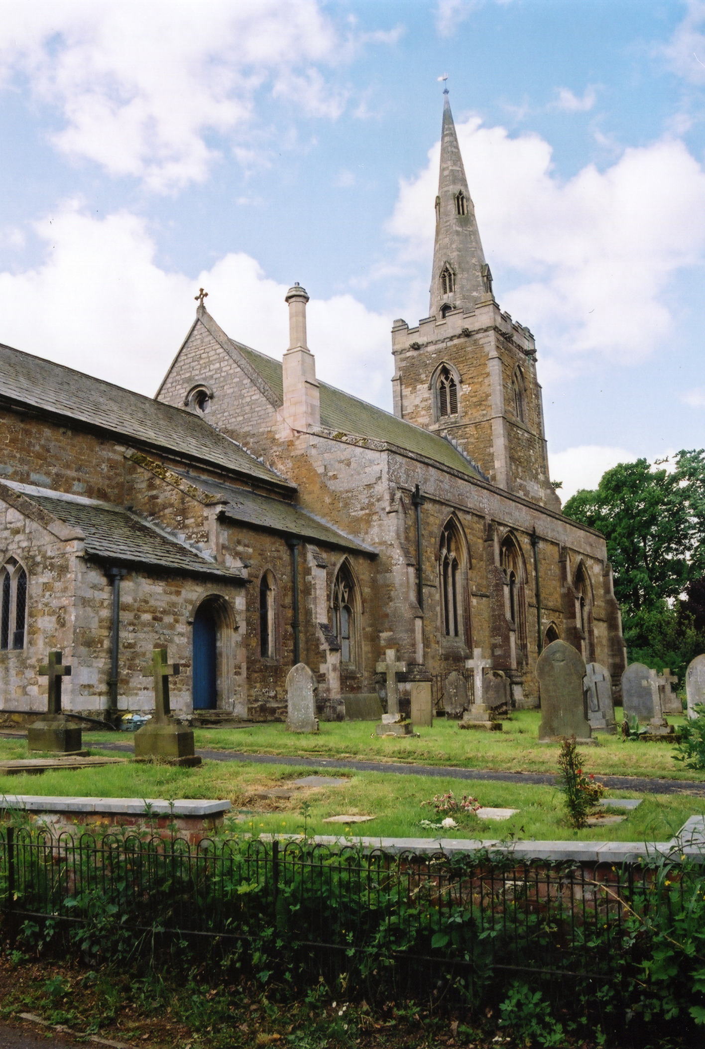
- The Anglican parish church is dedicated to All Saints, built in the Gothic (or Early English) style.
- The church was extensively restored in 1852 and an organ chamber added in 1870.
- The church was further restored in 1889-90.
- The church seats 360.
- There is a photograph of All Saints church on the Wendy PARKINSON Church Photos web site.
- Richard CROFT has a photograph of All Saints Church on Geo-graph, taken in December, 2007.
- Here are two photos of the church, taken by Ron COLE (who retains the copyright):

- Anglican Parish registers exist from 1538. Bishop's transcripts exist from 1562 to 1842.
- Barrowby marriages from 1651-1750 are covered in Boyd's Marriage Index, and from 1790-1837 in Pallot's Marriage Index.
- Parish registers are on file at the Society of Genealogists, covering 1538 - 1837.
- The LFHS has published several indexes for the Grantham Deanery to assist in your searches.
- Those researching the ALLEN/ALLIN surname will want to check our parish register extract. Your additions are welcome.
- The Independent (later "Free") Methodists had a small chapel here, built in 1840. The Wesleyan Methodists built theirs a few years later. For information and assistance in researching these chapels, see our non-conformist religions page.
- Check our Church Records page for county-wide resources.
- The parish was in the Grantham sub-district of the Grantham Registration District.
- After the Poor Law Union was re-organized in 1891, the parish was in the Grantham North sub-district of the Grantham Registration District.
- Check our Civil Registration page for sources and background on Civil Registration which began in July, 1837.
This village and parish are just west of Grantham. Harlaxton parish lies to the south, Woolsthorpe and Denton parish to the southwest and Muston, in Leicestershire, lies to the west. The parish covers about 4,400 acres.
The parish also included the hamlet of Casthorpe, which by 1841 consisted of only three farms.
The village of Barrowby is immediately west of the A1 trunk road and south of the A52, and about a mile and a half north of the Grantham and Nottingham Canal. The Foston Beck travels through the western side of the parish and feeds into the Grantham Canal. If you are planning a visit:
- Take the A1 Motorway to Grantham. This road curves around the west side of Grantham, where it connects to the A52 Trunk Road. Take the A52 west about 1/4 mile and turn south to Barrowby.
- David HARRIS has a photograph of the Village Sign on Geo-graph, taken in July, 2008. Keep an eye open for it!
- David DIXON goes him one better with a close-up of the Village Sign on Geo-graph, taken in September, 2013.
- Visit our touring page for more sources.
- Ask for a calculation of the distance from Barrowby to another place.
- Dr. HURST died here in 1687. He was a famous rector of Barrowby and Leadenham who became chaplain to Charles I. He was "plundered, imprisoned and ejected" due to his loyalty to the king.
- Check the history of the Wapentake at the Loveden Wapentake website.
- In 1899 a parish room was built by the Rev. Canon G. E. WELBU and presented to the parish. See: Archives and Libraries section above.
- Jonathan THACKER has a photograph of the White Swan public house on Geo-graph, taken in October, 2019.
- In 1841, roughly half the parish belonged to the Duke of Devonshire, who was lord of the manor. Sir J. C. THOROLD owned about one-quarter of the land and the rest belonged to the WELBY and other families.
- In 1872, things hadn't changed much. Roughly half the parish belonged to the Duke of Devonshire, lord of the manor. Sir J. H. THOROLD, baronet, owned about one-quarter of the land and the rest belonged to the WELBY, KELHAM and other families.
- In 1913, still half the parish belonged to the Duke of Devonshire, still lord of the manor. Sir John H. THOROLD, baronet, owned about one-quarter of the land and the rest belonged to the WELBY and other families.
- By 1842, Barrowby Hall had been reduced to a farm house and the surrounding moat drained and filled in.
- In 1872, the ancient hall was occupied by Mr. Thomas PINDER.
- Note: There is a Barrowby Hall in Nottinghamshire as well.
- See our Maps page for additional resources.
You can see maps centred on OS grid reference SK878365 (Lat/Lon: 52.918753, -0.695611), Barrowby which are provided by:
- OpenStreetMap
- Google Maps
- StreetMap (Current Ordnance Survey maps)
- Bing (was Multimap)
- Old Maps Online
- National Library of Scotland (Old Ordnance Survey maps)
- Vision of Britain (Click "Historical units & statistics" for administrative areas.)
- English Jurisdictions in 1851 (Unfortunately the LDS have removed the facility to enable us to specify a starting location, you will need to search yourself on their map.)
- Magic (Geographic information) (Click + on map if it doesn't show)
- GeoHack (Links to on-line maps and location specific services.)
- All places within the same township/parish shown on an Openstreetmap map.
- Nearby townships/parishes shown on an Openstreetmap map.
- Nearby places shown on an Openstreetmap map.
- In the church is a large bronze tablet with the names of the men who died in World War I.
- In 1930 Lt.-Col. Robert C. SWAN resided at Barrowby Grange.
From the Barrowby War Memorial (with additional notations), all by Eric WALTERS:
| Surname | Given names | Unit | Died | Cemetery | Notes |
|---|---|---|---|---|---|
| BATES | John William | 152 RFA | 27-Mar-1916 | St Marie le Havre | b |
| BATTERSBY | George | 193 MGC | 30-Mar-1918 | Anzin St Autin BC | |
| BLACKBOURNE | James W. | 10 Essex | 28-Dec-1918 | Barkstone St Nicholas | c |
| BLOODWORTH | Herbert | 217 RFA | 17-Aug-1917 | Tyne Cot Mem | |
| BOINTON | Norman | 10 Lincs | 28-Apr-1917 | Roeux BC | a |
| BONNETT | Alfred Edward | 2 SLI | 23-Oct-1918 | St Souplet BC | |
| BRYAN | Thomas | 5 Lincs | 17-Apr-1917 | Ste Emile Valley | |
| BULLOCK | John William | 4 Lincs | 13-Oct-1915 | Loos Mem | a |
| CHILVERS | Ernest | 8th S Foresters | 27-Oct-1915 | Abbeville Cty | |
| COY | Arthur | 8th Lincs | 21-Jan-1916 | Cite Bonjean MC | |
| DARBY | George Edward | S Notts Hussars | 06-Jul-1916 | Salonika Anglo-French | |
| GASCOIGNE | Albert | 1 Grenadier Guards | 22-Oct-1916 | Barrowby All Saints | |
| GASCOIGNE | Frederick | HMS Queen Mary | 31-May-1916 | Portsmouth Naval Mem | |
| GREEN | Tom | 20th Manchesters | 26-Oct-1918 | Premont BC | |
| HEPPENSTALL | Frederick Victor | 7th Lincs | 20-Feb-1918 | Rocquigny-Equancourt Rd | |
| HOLMES | Afred Basil | 4 KOYLI | 20-Jul-1918 | Soissons Mem | |
| HORNSBY | Richard L. | 6 Lincs | 07-Oct-1915 | Helles Mem | |
| KNOWLES | Tom | HM Torpedo Bt 7 | 10-Oct-1914 | Chatham Naval Mem | |
| MUSSON | John Francis | 3rd Coldstream | 24-Nov-1917 | Cambrai Mem | |
| MUSSON | Thomas Francis | 1st Scots Gds | 27-Nov-1917 | Cambrai Mem | |
| NORTH | Thomas James | 20 RGA | 08-Mar-1918 | Lapugnoy | d |
| OGDEN | Charles | Lincs Yeo | 03-Nov-1915 | Le Petit Lac Algeria | e |
| PEATMAN | Arthur | MGC | 13-Oct-1915 | Arras Mem | |
| SKIPWORTH | John Patrick | 255 RFA | 28-Mar-1918 | Arras Mem | |
| SMITH | Walter | 7 Lincs | 12-Oct-1917 | Tyne Cot Mem | |
| SOUTHERN | J. | MGC | 19-Nov-1918 | Barrowby All Saints | |
| SOUTHERN | T. | 15 Lancs Fus | 06-Nov-1918 | Premont BC | |
| SWALLOW | Alfred Bailey | 470 RE _ Field Coy | 21-Mar-1918 | Arras Mem | a |
| TOWERS | Alan | 4 Lincs | 13-Oct-1915 | Loos Mem |
Key - on other memorials as follows:
- Grantham
- Welton
- Barkston
- Lincoln GPO
- Lincoln
- The name derives from the Old Scandinavian berg+by, meaning "village on the hill". It appears as Bergebi in the 1086 Domesday Book. It is presumed that the Vikings founded Barrowby, but that is as yet unproven.
[A. D. Mills, "A Dictionary of English Place-Names," Oxford University Press, 1991].
- White's 1842 Directory lists the following surnames in the parish: ANNIS, ARCHER, ASHWELL, BULLIMORE, DAWN, DICKINSON, DOWNING, EMINSON, FREEMAN, FRIESTON, GARTON, GIBSON, IRELAND, JACKSON, JENKINSON, JOHNSTON, KENDAL, KING, KITTLE, MILLHOUSE, MORRIS, NELSON, PEARSON, PINDER, RICKITT, SAVIDGE, SHARP, SILLS, SMITH, STEPHENSON, TAYLOR, TROLLEY, VINCENT, WALFORD and WALKER.
- Kelley's 1913 Directory lists the following surnames in the parish: BLANKLEY, BLOODWORTH, BREWSTER, BRIGGS, BROOKS, BROWNLOW, BURROWS, DOWNING, FOYSTER, GASCOIGNE, GRIFFIN, GRIET, HOMES, HORNSBY, HULL, INGRAM, JARVIS, JUDSON, LYNN, MURGATROID, MUSSON, NATION, NAYLOR, NEWTON, PATMAN, PEARSON, PELL, PINDER, SHARP, SMIS, SMITH, STRANGE, SWALLOW, TATCHELL, TINKLER, WELBY, WIKSON and WOOMER.
- This place was an ancient parish in Lincolnshire and became a modern Civil Parish when those were established.
- The parish was in the ancient Loveden Wapentake in the South Kesteven district in the parts of Kesteven. Prior to the 1830s it had been in the Winnibriggs & Threo Wapentake.
- For today's district governance, contact the South Kesteven District Council.
- Bastardy cases would be heard in the Spittlegate (Grantham) petty session hearings.
- Lewis SOMERSALL and Thomas HURST, DD, donated rent-charges of 20 shillings each to go to the poor.
- Prior to 1842, various donors left £130, the interest to go to poor parishioners.
- As a result of the Poor Law Amendment Act of 1834, the parish became part of the Grantham Poor Law Union.
- A new school was first erected here in 1852. A Public Elementary School was erected about 1880 to hold 190 children.
- Jonathan THACKER has a photograph of the C of E Primary School on Geo-graph, taken in October, 2019.
- For more on researching school records, see our Schools Research page.