
Hide
Bracebridge
hide
Hide
hide
Hide
hide
Hide
Hide
hide
- Maps
- Medical Records
- Migration, Internal◬
- Military History
- Military Records
- Names, Geographical◬
- Names, Personal◬
- Naturalisation & Citizenship◬
- Newspapers◬
- Occupations◬
- Politics & Government
- Poor Houses, Poor Law
- Population
- Postal & Shipping Guides
- Probate Records◬
- Public Records◬
- Schools
- Societies◬
- Voting Registers◬
Hide
Hide
- The parish was in the Home ("Lincoln Home") sub-district of the Lincoln Registration District.
- We have a partial extract of surnames from the 1901 Census in a text file for your review. Your additions are welcome.
- Check our Census Resource page for county-wide resources.
- The table below gives census piece numbers, where known:
| Census Year | Piece No. |
|---|---|
| 1841 | H.O. 107 / 651 |
| 1861 | R.G. 9 / 2357 & 2358 |
| 1871 | R.G. 10 / 3369 |
| 1891 | R.G. 12 / 2589 |
| 1901 | R.G. 13 / 3059 |
| All Saints, Bracebridge, Church of England |
| St Columba, Bracebridge, Church of England |
| St John the Evangelist, Bracebridge, Church of England |
- The Anglican parish church is dedicated to All Saints.
- The church is built of stone. The building appears to date from the 13th century.
- In 1893 the tower was completely restored.
- The church seats 350 people.
- All Saints is located in Brant Road, off the Newark Road, Lincoln.
- The mission church of St. John the Evangelist was built after the cornerstone was laid in September, 1907.
- Richard CROFT has a photograph of All Saints Church on Geo-graph, taken in October 2005.
- And Richard CROFT has another photograph of All Saints Church on Geo-graph, taken in March, 2012.
- Here is a photo of All Saints Church, taken by Ron COLE (who retains the copyright):

- The Lincolnshire FHS has published several marriage indexes and a burial index for the Graffoe Deanery to make your search easier.
- The parish has also been in the Longoboby Deanery in the 1800s.
- The United Methodists had a chapel here by 1900. The Primitive Methodists built their chapel in 1872. For information and assistance in researching these chapels, see our non-conformist religions page.
- Check our Church Records page for county-wide resources.
- The parish was in the Home ("Lincoln Home") sub-district of the Lincoln Registration District.
- Check our Civil Registration page for sources and background on Civil Registration which began in July, 1837.
This village and parish lie just south of Lincoln in Lincolnshire, across the River Witham. Waddington parish is to the south. The parish only covers about 395 acres, far smaller than in earlier times. In 1881, the parish covered about 1,500 acres.
The village of Bracebridge Heath is the largest village in the parish, lying about a half mile from the River Witham. If you are planning a visit:
- By automobile, take the A15 trunk road south out of Lincoln or north out of Sleaford. Where the A607 arterial road out of Grantham intersects, you are in Bracebridge Heath village.
- Bracebridge Heath Village Hall is on Red Hall Lane, to the west of the A15 road.
- Visit our touring page for more sources.
- Ask for a calculation of the distance from Bracebridge to another place.
- Richard CROFT has a photograph of The Plough Inn on Geo-graph, taken in January, 2008.
- J. HANNAN-BRIGGS has a photograph of The Crow's Nest Pub on Geo-graph, taken in October, 2012.
- See our Maps page for additional resources.
You can see maps centred on OS grid reference SK963685 (Lat/Lon: 53.204859, -0.559674), Bracebridge which are provided by:
- OpenStreetMap
- Google Maps
- StreetMap (Current Ordnance Survey maps)
- Bing (was Multimap)
- Old Maps Online
- National Library of Scotland (Old Ordnance Survey maps)
- Vision of Britain (Click "Historical units & statistics" for administrative areas.)
- English Jurisdictions in 1851 (Unfortunately the LDS have removed the facility to enable us to specify a starting location, you will need to search yourself on their map.)
- Magic (Geographic information) (Click + on map if it doesn't show)
- GeoHack (Links to on-line maps and location specific services.)
- All places within the same township/parish shown on an Openstreetmap map.
- Nearby townships/parishes shown on an Openstreetmap map.
- Nearby places shown on an Openstreetmap map.
- The parish was home to the Lindsey and Holland counties and Lincoln and Grimsby District Lunatic Asylum. Please see our Bracebridge Asylum page for more information.
- The airfield at Bracebridge Heath was opened in 1916 by Lincoln-based aircraft manufacturer Robey for the manufacture and flight testing of the Sopwith aircraft.
- The Royal Flying Corps took over the field in 1917 and assigned 121 Squadron to it.
- During WWII, the field was used to repair damaged AVRO Lancaster bombers and return them to service.
- On 28 March 1942 a Lancaster bomber hit another plane over the parish. The whole crew was lost.
- For additional military information, see our Military Records page.
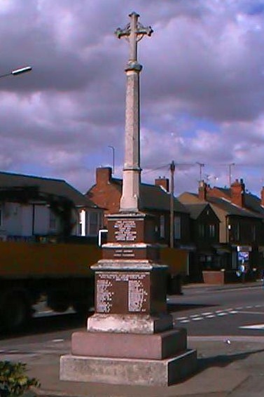
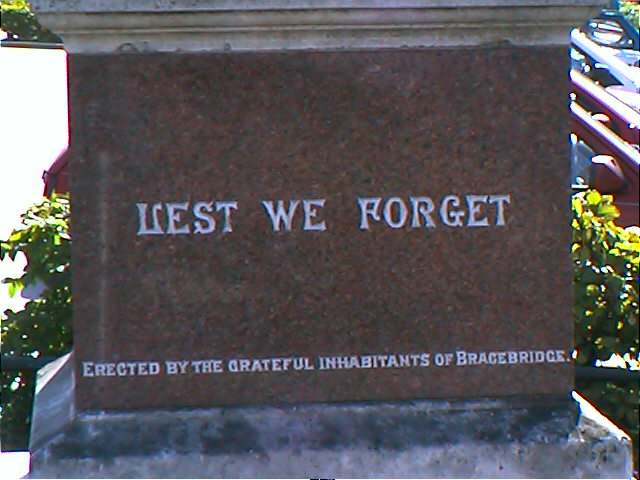
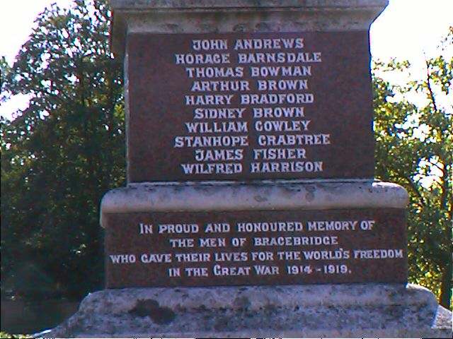
- For a photograph of the Bracebridge War Memorial and the names inscribed on it, see the Roll of Honour site.
John Emerson, who retains the copyright, provides these photographs of the war memorial at Bracebridge:


- The parish was in the ancient Graffoe (or Boothby Graffoe) Wapentake in the Central Lindsey division of the county, parts of Lindsey.
- In ancient times, the parish was a Liberty of Lincoln.
- Boundary realignments sometimes placed the parish in the West Lindsey division of the county. It is also considered part of the Lincoln City Parliamentary Borough as of 1885. The village formed its own Urban District Council in April, 1898.
- The civil parish is technically "Bracebridge Heath". It was formed on 31 March, 1898 from the old ecclesiastical parish of Bracebridge.
- Bastardy cases would be heard in the Lincoln petty session hearings.
- As a result of the 1834 Poor Law Amendment Act reforms, the parish became part of the Lincoln Poor Law Union.
Population figures for this parish often include the large county asylum's inmates and staff as well.
Year Inhabitants 1801 145 1821 155 1831 158 1851 340 1871 1,203 1881 2,120 1911 1,523
- A school board was formed in 1878. Their district included Boultham parish.
- A girls' and infants' school was built here at South Cliff in 1880.
- A boys' school was built here in 1902.
- For more on researching school records, see our Schools Research page.