
Hide
Digby
hide
Hide
hide
Hide
hide
Hide
Hide
hide
Hide
Hide
- The parish was in the Sleaford sub-district of the Sleaford Registration District.
- Check our Census Resource page for county-wide resources.
- The table below gives census piece numbers, where known:
| Census Year | Piece No. |
|---|---|
| 1841 | H.O. 107 / 617 |
| 1851 | H.O. 107 / 2100 |
| 1861 | R.G. 9 / 2342 |
| 1871 | R.G. 10 / 3349 |
| 1891 | R.G. 12 / 2577 |
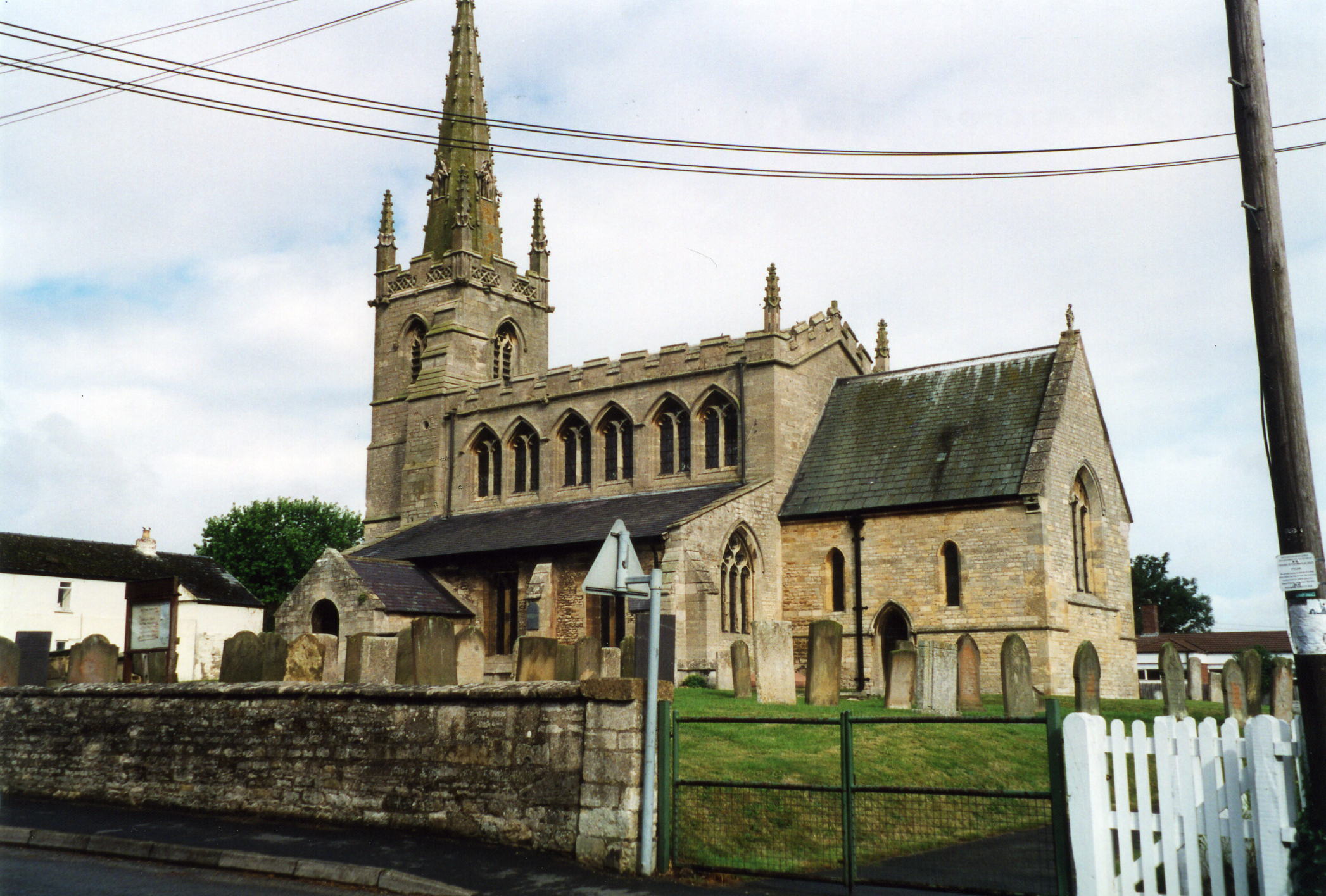
- The Anglican parish church is dedicated to St. Thomas-a-Becket and was built in the Gothic style with a tall spire.
- The church seats about 150.
- There is a photograph of St. Thomas-a-Becket church on the Wendy PARKINSON web site.
- David HITCHBORNE has a photograph of The Church of St Thomas a Beckett on Geo-graph, taken in August, 2013.
- Here is a photo of St. Thomas's Church, taken by Ron COLE (who retains the copyright):
- The Anglican parish register dates from 1560.
- The Lincolnshire FHS has a Loan Library service which has the parish registers on microfiche for Baptisms from 1679 to 1813 and Marriages from 1679 to 1733.
- The LFHS has published several marriage and burial indexes for the Lafford Deanery to make your search easier.
- There was an Wesleyan Methodist chapel built in the parish in 1879. Check our Non-Conformist Church Records page for additional resources.
- Check our Church Records page for county-wide resources.
- The parish was in the Sleaford sub-district of the Sleaford Registration District.
- Check our Civil Registration page for sources and background on Civil Registration which began in July, 1837.
This village and parish are 6 miles north of Sleaford, on the B1188 trunk road. The parish covers about 2,350 acres.
The village is in the vale of a small rivulet (the Digby Beck). If you are planning a visit:
- By automobile, take the A15 trunk road north out of Sleaford, take a right on the B1191 arterial to Ashby, then right at Ashby to drive out to Digby village.
- Alex McGREGOR has a photograph of the Village sign on Geo-graph, taken in May, 2011.
- Consider staying at Woodend Farm, LN4 3NG; tele: 01526-860347.
- See our touring page for more sources.
- Ask for a calculation of the distance from Digby to another place.
- See the Parish Council site (Politics) for a list of recent Roman-era finds.
- In 1604, during the warm months of July, August and September, no fewer than 134 people died here of the plague.
- Richard CROFT has a photograph of the Digby Lockup on Geo-graph, taken in May, 2006. It appears that only one person at a time could commit a crime.
- The village contains an ancient cross.
- Richard CROFT also has a photograph of the Red Lion Inn with the ancient cross in the left foreground on Geo-graph, taken in April, 2009.
- Digby Manor was formerly a seat of the DIGBY family. The manor has also been owned by the THORNTON and RIDER families. In 1842 through 1872, the manor belonged to the Earl of Harrowby.
- The national grid reference is TF 0854.
- You'll want an Ordnance Survey "Explorer 272" map, which has 2.5 inches to the mile scale.
- See our "Maps" page for additional resources.
You can see maps centred on OS grid reference TF081549 (Lat/Lon: 53.080054, -0.387869), Digby which are provided by:
- OpenStreetMap
- Google Maps
- StreetMap (Current Ordnance Survey maps)
- Bing (was Multimap)
- Old Maps Online
- National Library of Scotland (Old Ordnance Survey maps)
- Vision of Britain (Click "Historical units & statistics" for administrative areas.)
- English Jurisdictions in 1851 (Unfortunately the LDS have removed the facility to enable us to specify a starting location, you will need to search yourself on their map.)
- Magic (Geographic information) (Click + on map if it doesn't show)
- GeoHack (Links to on-line maps and location specific services.)
- All places within the same township/parish shown on an Openstreetmap map.
- Nearby townships/parishes shown on an Openstreetmap map.
- Nearby places shown on an Openstreetmap map.
- Digby was the site of a military airfield in World War One. It was used for training until 1935/6. Following that, it was home of Fighter Command's 12 Group. Several aircraft from Digby played an important role in the Battle of Britain. In 1940, the Canadian 402 (of the RCAF) was posted here and in 1942 Digby became an official Canadian airfield. At the end of WWII, it was transferred back to the RAF.
- Richard CROFT has a photograph of the refurbished war memorial by the church on Geo-graph, taken in July, 2009.
There is a photograph of the war memorial in the churchyard and the list of the names from the Roll of Honour at the Roll of Honour site.
Here's a newspaper clipping mentioning the village. Unfortunately, the newspspaer's name is lost, but the date is 13 Oct. 1917: Diane Maltby
DIGBY
DIED OF WOUNDS.- We regret to report the death of Lce.-Corpl. Bertie Bloy, who died of his wounds on September 28th in France. Deceased was the second son of Mr. George Bloy, and had been at the Front for some time. Mr. Bloy has received a kind and sympathetic letter from the chaplain. Though severely wounded in the head and arms, Mr. Bloy was quite conscious, and in his last moments asked the chaplain to recite the beautiful hymn. "The King of Love My Shepherd is", he himself joining in at the last line of the verse. It will be remembered that his elder brother was wounded at Mons, and the youngest son both are doing their bit. The deepest sympathy is felt for Mr. Bloy and family. After the evening service at the Parish Church on Sunday special prayers and the National Anthem were sung for Sir Douglas Haig's great victory.
And from 27 Oct. 1917: Diane Maltby
DIGBY
GOOD LUCK!- Miss L. C. King, who joined the W. A.. A. C., has just been drafted to the Front, and we wish her success in her new undertaking.
- This place was an ancient parish in county Lincoln and became a modern Civil Parish when those were established.
- The parish was in the ancient Flaxwell Wapentake in the North Kesteven district of the county, in the parts of Kesteven.
- You may contact the local Digby Parish Council regarding civic or political issues, but they are NOT staffed to answer family history questions.
- For today's district governance, see the North Kesteven District Council.
- Bastardy cases would be heard in the Sleaford petty session hearings every Monday.
- The parish Common Lands were enclosed in 1720.
- In 1761, Henry YOUNG left nine acres of land at Frieston as rental income for this parish. 20 shillings per year went to four poor widows. The remainder went for the education of poor children.
- In 1802, the parish trustee received £146, 9 shillings and 6 pence for part of the land taken for the Hobhole drain. The money was deposited and the interest used to care for the poor.
- After the 1834 Poor Law Amendment Act reforms, the parish became part of the Sleaford Poor Law Union.
- There was a school here before 1842. In that year it housed eight free scholars from the parish. It was enlarged in 1897.
- For more on researching school records, see our Schools Research page.