
Hide
Frithville
hide
Hide
hide
Hide
hide
Hide
Hide
Hide
The Library at Boston will prove useful in your research.
Richard CROFT has a photograph of the church and church graveyard on Geo-graph, taken in November 2005.
- The parish was in the Sibsey sub-district of the Boston Registration District.
- Check our Census Resource page for county-wide resources.
- The table below gives census piece numbers, where known:
| Census Year | Piece No. |
|---|---|
| 1841 | H.O. 107 / 633 |
| 1851 | H.O. 107 / 2098 |
| 1861 | R.G. 9 / 2334 |
| 1871 | R.G. 10 / 3339 |
| 1891 | R.G. 12 / 2572 |
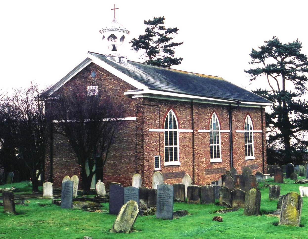
- The Anglican parish church is dedicated to Saint Peter.
- It was built in 1821 in the village of Mount Pleasant and seats 200. The parish register, naturally, dates from 1821.
- In 1821, parts of Frithville, Sibsey and Westville civil parishes were formed into an ecclesiastical parish.
- A small mission church was built at Fishtoft Drove some time before 1910.
- A Church Sunday School and reading room was erected in 1908.
- Here is a photo of the church, taken by (and copyright of) Norma CLARE.

- Here is a photo of St. Peter's Church, taken by Ron COLE (who retains the copyright):
- The Anglican parish register dates from 1821.
- We have the beginning of a Parish Register Extract as a text file for your use. Your additions and corrections would be appreciated.
- The LFHS has published several indexes for the Holland East Deanery to make your search easier.
- The Wesleyan Methodists had a chapel built in 1899 to replace an older, smaller chapel.
- Kate NICOL has a photograph of the Wesleyan Methodist Chapel on Geo-graph, taken in January, 2009.
- For more on researching these chapel records, see our non-conformist religions page.
- Check our Church Records page for county-wide resources.
- The parish was in the Sibsey sub-district of the Boston Registration District.
- Check our Civil Registration page for sources and background on Civil Registration which began in July, 1837.
Frithville is both a parish and a village which lie in the Fens about 5 miles north of Boston. The parish covers about 4,200 acres and includes the former parish (or extra-parocial land) of Westville, which is 7 miles north of Boston. It also includes the village of Mount Pleasant.
Frith Bank is a hamlet in nearby Sibsey parish.
If you are planning a visit:
- To get to Frithville village, take the B1183 trunk road north out of Boston. Where it crosses the B1184, there is Frithville!
- See our Touring page for additional resources.
- Ask for a calculation of the distance from Frithville to another place.
- See our Maps page for additional resources.
You can see maps centred on OS grid reference TF318506 (Lat/Lon: 53.036207, -0.035191), Frithville which are provided by:
- OpenStreetMap
- Google Maps
- StreetMap (Current Ordnance Survey maps)
- Bing (was Multimap)
- Old Maps Online
- National Library of Scotland (Old Ordnance Survey maps)
- Vision of Britain (Click "Historical units & statistics" for administrative areas.)
- English Jurisdictions in 1851 (Unfortunately the LDS have removed the facility to enable us to specify a starting location, you will need to search yourself on their map.)
- Magic (Geographic information) (Click + on map if it doesn't show)
- GeoHack (Links to on-line maps and location specific services.)
- All places within the same township/parish shown on an Openstreetmap map.
- Nearby townships/parishes shown on an Openstreetmap map.
- Nearby places shown on an Openstreetmap map.
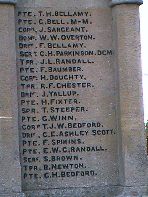
The War Memorial is a Gothic plinth surmounted by a spire and cross that was installed at the junction of Westville and Carrington Roads and dedicated in April 1920. Of the 85 names listed, 63 served and returned.
J. THOMAS has a photograph of the War Memorial on Geo-graph, taken in March, 2014.
John EMERSON, who retains the copyright, provides these photographs of the war memorial at Frithville:
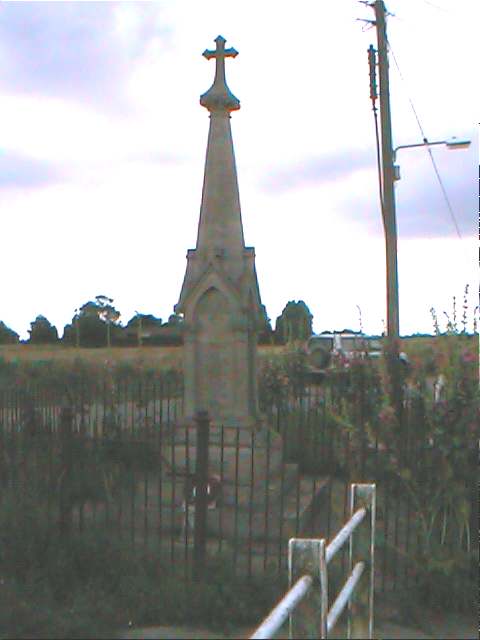

To see a list of the names on the monuments, see the Roll of Honour site.
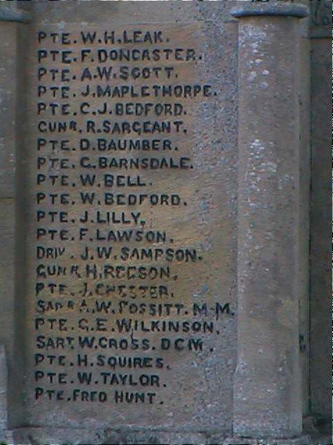
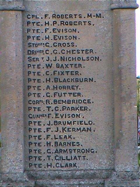
These are the names as provided by the Imperial War Museum (no ranks or servide details were provided):
- Armstrong, George
- Ashley Scott, C. E.
- Balderston, Thomas Harold
- Barnes, Harry
- Barnsdale, G.
- Baumber, D.
- Baumber, F.
- Baxter, William
- Bedford, C. J.
- Bedford, G. H.
- Bedford, Thomas J. W.
- Bedford, W.
- Bell, G.
- Bell, W.
- Bellamy, F.
- Bellamy, T. H.
- Bembridge, Robert
- Blackburn, H.
- Bradley, C. E.
- Brown, S.
- Brumfield, James
- Carey, F.
- Chester, Charles George
- Chester, J.
- Chester, R. F.
- Clark, G.
- Clark, Herbert
- Clay, J. H.
- Cross, George
- Cross, W.
- Doncaster, F.
- Doughty, H.
- Evison, Frederick
- Evison, Frederick (yes, there's two of them)
- Evison, Harry
- Fixter, George
- Fixter, H.
- Fossitt, A. W.
- Futter, George
- Gilliatt, T.
- Hewson, G.
- Horrey, Albert
- Houlden, G. H.
- Hunt, A.
- Hunt, Fred
- Kenrick, E.
- Kerman, Frederick James
- Lawson, F.
- Leak, Fred
- Leak, W. H.
- Lilly, J.
- Maplethorpe, J.
- Newton, B.
- Newton, G.
- Nicholson, John James
- Overton, W. W.
- Palmer, E. J.
- Palmer, J. H.-
- Parker, Thomas Cyril
- Parkinson, G. H.
- Randall, E. W. G.
- Randall, J.
- Randall, J. L.
- Reeson, H.
- Roberts, Frank
- Roberts, Harold Percy
- Roberts, S. E.
- Robinson, E. D.
- Robinson, G. S.
- Samson, J. W.
- Sargeant, J.
- Sargeant, R.
- Scott, A. W.
- Scott, J. H.
- Spikins, F.
- Squires, H.
- Steeper, T.
- Taylor, W.
- Templeman, W.
- Toyne, H.
- Vere, J. W.
- Wilkinson, G. E.
- Winn, G.
- Yallup, J.
- Yates, W.
- The name derives from the Old English Fyrhth, meaning "sparse woodland", with the French "ville" added at a later date. It appears in 1331 as Le Frith.
A. D. Mills, "A Dictionary of English Place-Names," Oxford University Press, 1991.
- The village and parish are sometimes called Boston East. ("Boston North" would have been more accurate.)
- The parish was formed from several other parishes in the reign of George III.
- The parish became a township in 1812.
- The parish became a Civil Parish in December, 1866.
- Parish boundaries were "adjusted" in December, 1880.
- The parish was listed in many records as "Boston East".
- The parish was in the West division of the ancient Bolingbroke Wapentake in the East Lindsey district in the parts of Lindsey.
- The parish was also in the Bolingbroke Soke.
- You may contact the local Frithville & Westville Parish Council regarding civic or political matters, but they are NOT staffed or funded to help you with family history questions.
- J. THOMAS has a photograph of the Frithville and Westville Village Hall on Geo-graph, taken in March, 2014. Parish Council meetings are held here every other month.
- For today's district governance, see the East Lindsey District Council.
- Bastardy cases would be heard in the Spilsby petty session hearings every other week.
- As a result of the 1834 Poor Law Amendment Act reforms, this parish became a part of the Boston Poor Law Union.
- The parish hosted a Sick and Dividend Club in the early 1900's.
- This parish was included in the West Fen United School District, formed on 10 January, 1879. The children attended a council school in Frithville, erected in 1880 and enlarged in 1912.
- See our Schools page for more information on researching school records.