
Hide
Limber Magna (Great Limber)
hide
Hide
hide
Hide
hide
Hide
Hide
Limber Magna, par. and vil., Lincolnshire, on the Wolds - par., 5,180 ac., pop. 489; vil., 5 miles NE. of Caistor; P.O., called Limber; the par. contains hamlet of Limber Parva.
From: John BARTHOLOMEW's "Gazetteer of the British Isles (1887)"
Hide
The Caistor Library is an excellent resource with a Local History section and a Family History section.
- Kevin WATERHOUSE has a photograph of the Pelham Mausoleum on Geo-graph, taken in July, 2018.
- The lych gate to the churchyard was built in 1912 in memory of John MAUNSELL-RICHARDSON.
- Paul GLAZZARD has a photograph of the church graveyard on Geo-graph, taken in July, 2008.
- The parish was in the Caistor sub-district of the Caistor Registration District.
- Check our Census Resource page for county-wide resources.
- The table below gives census piece numbers, where known:
| Census Year | Piece No. |
|---|---|
| 1841 | H.O. 107 / 639 |
| 1851 | H.O. 107 / 2114 |
| 1861 | R.G. 9 / 2393 |
| 1871 | R.G. 10 / 3422 |
| 1881 | R.G. 11 / 3280 |
| 1891 | R.G. 12 / 2622 |
| 1901 | R.G. 13 / 3098 |
- The parish was the home of a Norman priory, under the Abbey of L'Aulnay in Normandy. The Priory was built before 1180.
- The Knights Templar had a preceptory here.
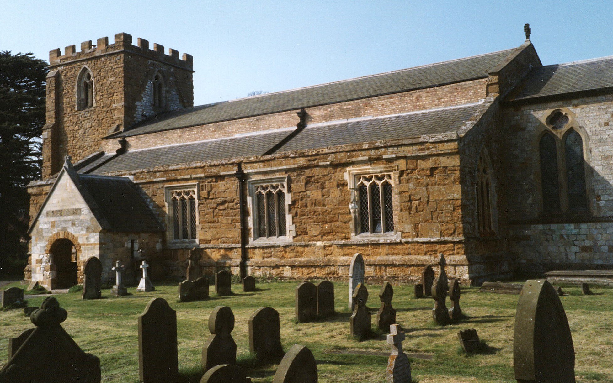
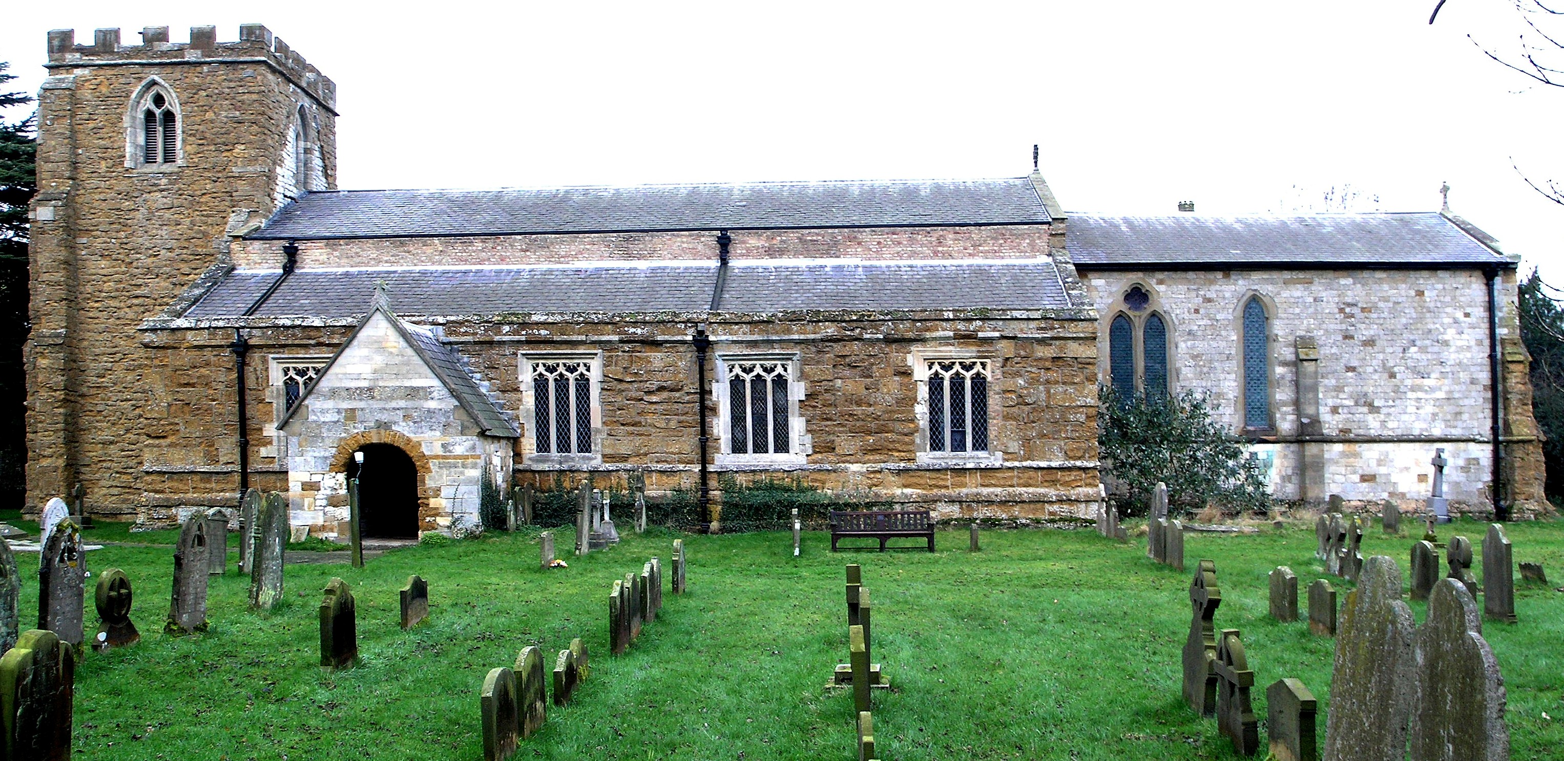
- The Anglican parish church is dedicated to Saint Peter and was built in the Norman and Decorated styles.
- The church was restored in 1875.
- The church seats 350.
- There is a photograph of St. Peter's church on the Wendy PARKINSON web site under "Yet More Lincolnshire".
- Richard CROFT has a photograph of St. Peter's church on Geo-graph, taken on a sunny day in March, 2006.
- Here are two photographs of St. Peter's, taken by Ron COLE (who retains the copyright):
- The Anglican parish register dates from 1562.
- The Lincolnshire FHS has published several marriage indexes and a burial index for the Yarborough Deanery to make your search easier.
- The Wesleyan Methodists built a chapel here in 1841.
- Ian S. has a photograph of the Old Wesleyan Chapel on Geo-graph, taken in January, 2018.
- For information and assistance in researching these chapels, see our non-conformist religions page.
- Check our Church Records page for county-wide resources.
- The parish was in the Caistor sub-district of the Caistor Registration District.
- Check our Civil Registration page for sources and background on Civil Registration which began in July, 1837.
Great Limber or Limber Magna is both a village and a parish about 10 miles east of Brigg and 10 miles west of Grimsby. Brocklesby parish is to the north and Clixby parish to the south. The Humberside International Airport is just to the north-west. The parish covers almost 5,200 acres.
Much of the village is part of a county Conservation Area, If you are planning a visit:
- By automobile, take the A18 east out of Brigg, It passes right through Great Limber.
- Stop in at the Village Hall on Church Lane and get a schedule of current events. Here's a photograph of the Hall on Geo-graph, taken by Paul GLAZZARD in July, 2008. Bring your kids and their toy sailboats!
- See the Lincolnshire Touring and Holidays page on this site.
- Ask for a calculation of the distance from Limber Magna (Great Limber) to another place.
For more information on the TENNEY family, check the Tenney Family Association website. Edward TENNEY was born in Great Limber in 1490.
David WRIGHT has a photograph of Boundary Farm House built in 1773 on geo-graph, taken in November, 2006.
Ian S. has a photograph of the New Inn on Geo-graph, taken in January, 2018.
- See our Maps page for additional resources.
You can see maps centred on OS grid reference TA135086 (Lat/Lon: 53.561752, -0.28788), Limber Magna (Great Limber) which are provided by:
- OpenStreetMap
- Google Maps
- StreetMap (Current Ordnance Survey maps)
- Bing (was Multimap)
- Old Maps Online
- National Library of Scotland (Old Ordnance Survey maps)
- Vision of Britain (Click "Historical units & statistics" for administrative areas.)
- English Jurisdictions in 1851 (Unfortunately the LDS have removed the facility to enable us to specify a starting location, you will need to search yourself on their map.)
- Magic (Geographic information) (Click + on map if it doesn't show)
- GeoHack (Links to on-line maps and location specific services.)
- All places within the same township/parish shown on an Openstreetmap map.
- Nearby townships/parishes shown on an Openstreetmap map.
- Nearby places shown on an Openstreetmap map.
- In 1871, the village was the headquarters of the 1st Lincolnshire Light Horse Volunteers, which had 75 members. The Earl of Yarborough was the Captain-Commandant; William THOROLD, Lieutenant; W. RICHARDSON, trumpeter; G. W. GORDON, trumpeter; and Sergeant Thomas Wm. SMITH, Drill Instructor.
- In 1881, the village was still the headquarters of the 1st Lincolnshire Light Horse Volunteers, which had 78 members. The Earl of Yarborough was the Captain-Commandant; John M. RICHARDSON and W. SWALLOW, Lieutenants; and Sergeant-Major MURDOCK, Drill Instructor.
- John Maunsell RICHARDSON, above, was born in Great Limber circa 1847. He was single and a landlord in 1881. He is remembered on the Church lychgate. He appears to have married Victoria A. HARE in late 1881 and settled in Healing, LIN. Her birthplace is given as London, Middlesex.
- The RAF had an airfield here in World War II, but it was what is called a "Q-site", used to decoy German planes into attacking dummy targets while taking anti-aircraft fire. There is a report of a crash by an RAF plane here in August, 1942, but that is not confirmed as yet by written sources. There was a Lancaster III bomber that crashed in Brocklesby Park area in March 1945.
- In 1930, Brig.-General Cuthbert Gurney HOARE, C.M.G. lived in the parish. He was a Sandhurst graduate (bottom of his class!) and a member of the landed gentry who joined the army in 1901. Near the end of World War I he was posted to Canada to start a program training Canadian pilots for the military. In the 1901 census, he is an 18-year-old Gentleman cadet at Sandhurst. He would die in Norwich, NFK, in March 1969.
- During the invasion fears of 1940, the Brocklesby park mausoleum just north of the village was used as a secret signal station for auxiliary units who would resist the Germans. David WRIGHT has a photograph of the Mausoleum on Geo-graph, taken in July, 2007.
- David WRIGHT has a photograph of the interesting War Memorial inside the church on Geo-graph, taken in January, 2010.
- The Imperial War Museum has no list of the names on this war Memorial.
Samuel NEEDHAM was born in Limber Magna on 16 Aug. 1885 and died at Kantara, Egypt on 4 Nov. 1918. He was a private in the Bedfordshire Regt. He was awarded the Victoria Cross posthumously. His name is NOT listed on the Kantara Memorial, but he is buried in the cemetery there.
There are two Commonwealth War Graves in Great Limber's churchyard:
- Walter BAXTER, pte. 7th Royal Sussex Regt., died 24 Nov 1918, age 24. Son of Mr. and Mrs. W. BAXTER.
- John Smith EYRE, pte. Royal Army Ordnance Corps, died 14 Oct 1919, age 38. Son of the late Mrs. Annie EYRE.
- This place was an ancient parish in Lincolnshire and became a modern Civil Parish when those were established.
- The parish was in the ancient Yarborough Wapentake in the West Lindsey district in the parts of Lindsey.
- Today's district governance is provided by the West Lindsey District Council.
- Bastardy cases would be heard in the Caistor petty session hearings on the fourth Wednesday of each month and nearly every Saturday.
- In 1626, Mr. Robert SMITH left 10 acres of land at Cadney-cum-Housham to generate rent revenue for the poor. The money was given as clothes and coal.
- As a result of the 1834 Poor Law Amendment Act, the parish became part of the Caistor Poor Law Union.
- In this parish are the Brocklesby Park Schools, first built in 1849 by the Earl Yarborough. These schools serve the parishes of Brocklesby, Keelby, Kirmington and Habrough.
- For more on researching school records, see our Schools Research page.