
Hide
Harmston
hide
Hide
hide
Hide
hide
Hide
Hide
hide
Hide
Hide
- The parish was in the South West sub-district of the Lincoln Registration District.
- Wendy Parkinson has the Harmston 1861 census transcribed and indexed online.
- Check our Census Resource page for county-wide resources.
- The table below shows census piece numbers, where known:
| Census Year | Piece Numbers |
|---|---|
| 1841 | H.O. 107 / 619 |
| 1861 | R.G. 9 / 2354 |
| 1871 | R.G. 10 / 3364 |
| 1891 | R.G. 12 / 2586 |
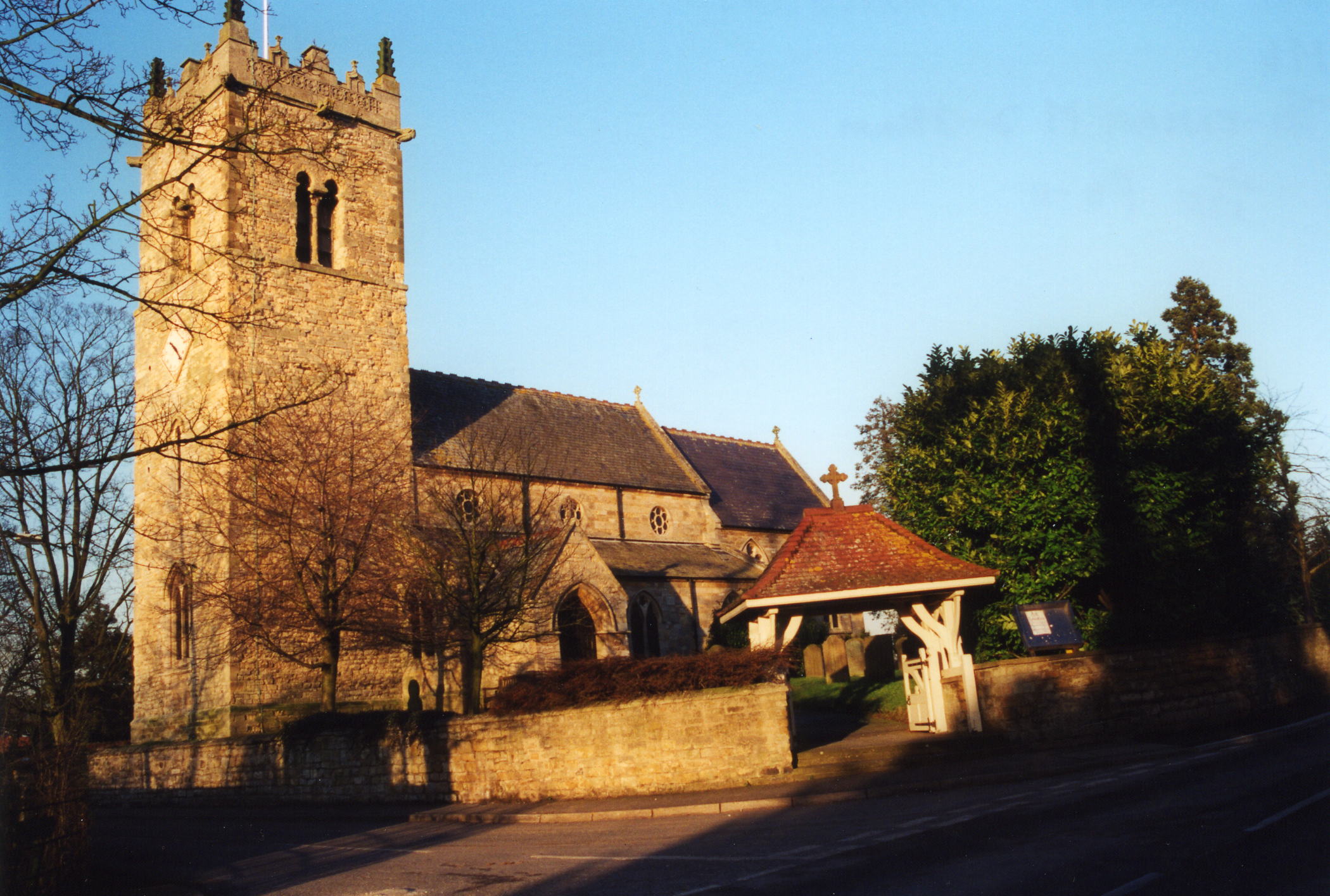
- The Anglican parish church is dedicated to All Saints, built of stone, apparently from the Norman period.
- The whole church was rebuilt, except for the tower, in 1717, by Sir George THOROLD.
- In 1868 the church was partly rebuilt and remodelled.
- The church seats 240.
- Gary BROTHWELL has a photograph of All Saints' Church on Geo-graph, taken in September, 2010.
- Here is a photo of All Saints Church, taken by Ron COLE (who retains the copyright):
- The parish register dates from 1563.
- We have a handful of entries in our Parish Register Extract text file. Your additions are welcome.
- The Lincolnshire FHS has published several marriage indexes and a burial index for the Graffoe Deanery to make your search easier. In the early 20th century, this was the rural Longoboby Deanery.
- The parish had a Wesleyan Methodist and a Reformed Methodist chapel. For information and assistance in researching these chapels, see our non-conformist religions page.
- Check our Church Records page for county-wide resources.
- The parish was in the South West sub-district of the Lincoln Registration District.
- Check our Civil Registration page for sources and background on Civil Registration which began in July, 1837.
This village and parish lie 6 miles south of Lincoln and just south of Waddington. Auborn parish is to the west across the River Witham and Coleby parish to the south. The parish covers about 2,570 acres.
The village is described in Scanlon and Warner's "The Kings England: Lincolnshire," publ. 1949, as:
"Serene among innumerable trees on its high place on the Cliff, it looks far over the valley where the Brant falls into the Witham and the Roman Foss Was is nearing Lincoln. On the eastern side of the village is Ermine Street."
- Take the A15 trunk road, south out of Lincoln and turn off at the southbound A607 trunk road. Follow that south and pass through Waddington village. One mile further south, just to the right, is Harmston village.
- Railway service to village ceased in 1962.
- Visit the Thorold Arms Pub near the village church.
- See our touring page for more sources.
- Ask for a calculation of the distance from Harmston to another place.
- The village is mentioned in the 1086 Domesday Book.
- The railway station, a half mile west of the village, was on the Lincoln to Grantham Branch of the Great Northern Railway.
- Harmston remained a very small village until the mid-1990s when the new owner of Harmston Hall (a local property developer) made plans for a new housing development on the former hospital site (expected completion in 2005). The new housing has brought many new people into the community and has transformed Harmston from an agricultural hamlet to a mainly commuter village for workers in nearby Lincoln.
- Richard CROFT has a photograph of the Thorold Arms Inn on Geo-graph, taken in July, 2013.
- Harmston Hall is a large stone mansion at the northern perimeter of the village, erected in 1710 for Sir Charles THOROLD and also the one-time home of Sir George THOROLD who was Lord Mayor of London in 1719. The manor here has belonged to the THOROLD family since at least 1456.
- In 1871, the manor house was unoccupied.
- In 1881, the manor house was the residence of Mr. Thomas BASTIN.
- In 1930, as a result of the Local Government Act, Harmston Hall became part of a new mental health hospital complex, and functioned as the headquarters for the organisation 'Lincolnshire Joint Board for Mental Defectives'. The hospital site finally closed down in 1989 and was soon redeveloped to become a private home once again.
- See our Maps page for additional resources.
You can see maps centred on OS grid reference SK973623 (Lat/Lon: 53.148964, -0.546592), Harmston which are provided by:
- OpenStreetMap
- Google Maps
- StreetMap (Current Ordnance Survey maps)
- Bing (was Multimap)
- Old Maps Online
- National Library of Scotland (Old Ordnance Survey maps)
- Vision of Britain (Click "Historical units & statistics" for administrative areas.)
- English Jurisdictions in 1851 (Unfortunately the LDS have removed the facility to enable us to specify a starting location, you will need to search yourself on their map.)
- Magic (Geographic information) (Click + on map if it doesn't show)
- GeoHack (Links to on-line maps and location specific services.)
- All places within the same township/parish shown on an Openstreetmap map.
- Nearby townships/parishes shown on an Openstreetmap map.
- Nearby places shown on an Openstreetmap map.
- Nathaniel Clayton COCKBURN, a major in the Imperial Yeomanry, gave the Village Memorial Hall in memory of the Harmston men who had lost their lives in World War I.
- This place was an ancient parish in Lincoln County and became a modern Civil Parish when those were established.
- The parish was in the ancient Graffoe (or Boothby Graffoe) Wapentake in the North Kesteven division of the county, in the parts of Kesteven.
- You may contact the local Harmston Parish Council regarding civic or politcal issues, but they are NOT staffed to help with family history lookups.
- For today's district governance, see the North Kesteven District Council.
- Bastardy cases would be heard at the Lincoln South petty session hearings.
- In 1715, Sir Christopher NEVILE and other donors purchased land in nearby Waddington and left the rental income for the poor of this parish.
- As a result of the 1834 Poor Law Amendment Act, the parish became part of the Lincoln Poor Law Union.
Year Inhabitants 1801 235 1831 405 1841 429 1851 414 1871 368 1881 345 1891 328 1901 327 1911 277 1921 301 ~2001 800
- The Public Elementary School was built in 1851 to house 152 children.
- For more on researching school records, see our Schools Research page.