
Hide
Horbling
hide
Hide
hide
Hide
hide
Hide
Hide
hide
Hide
Hide
The Library at Bourne will prove useful in your research.
- David HITCHBORNE has a photograph of the churchyard on Geo-graph, taken in August, 2013.
- J. HANNAN-BRIGGS has a photograph of the church and churchyard on Geo-graph, taken in June, 2015.
- The parish was in the Aslackby sub-district of the Bourne Registration District.
- Check our Census Resource page for county-wide resources.
- The table below gives census piece numbers, where known:
| Census Year | Piece No. |
|---|---|
| 1841 | H.O. 107 / 619 |
| 1851 | H.O. 107 / 2095 |
| 1861 | R.G. 9 / 2316 |
| 1871 | R.G. 10 / 3313 |
| 1891 | R.G. 12 / 2256 |
- The priory of Holland Bridge was founded by Godwin of Lincoln before 1200 and was dedicated to St. Saviour. The ruins of the priory are at the east end of the parish, near Car Dyke.
- According to the 1086 Domesday Book, there was a Christian Church here before the Conquest.
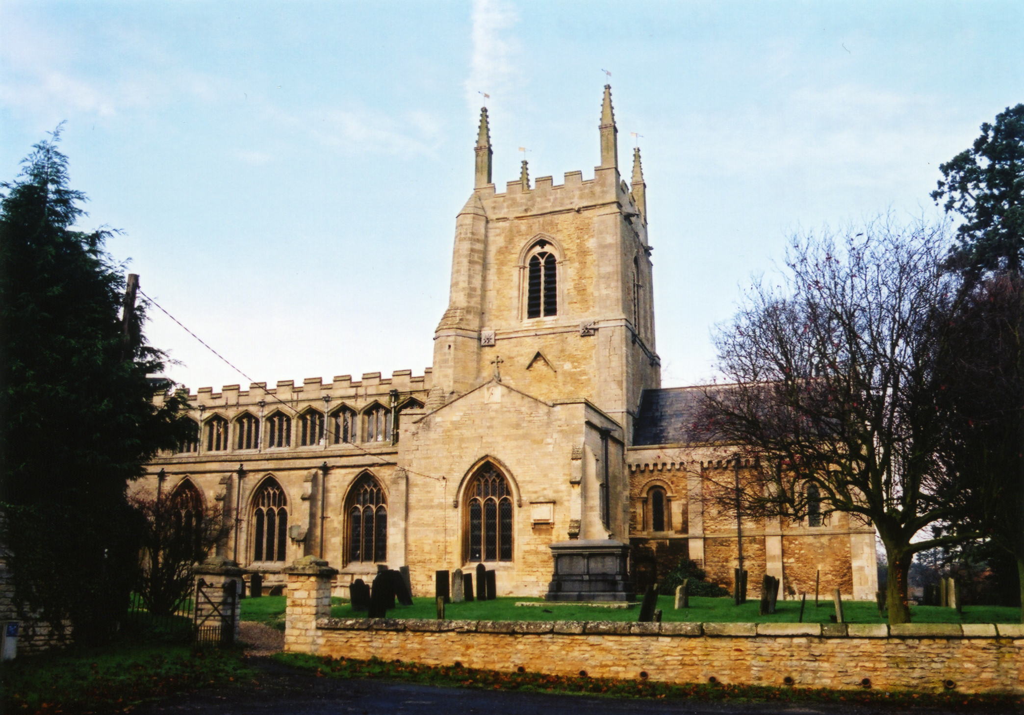
- The Anglican parish church is dedicated to St. Andrew.
- Some portions of the church building appear to be from the early Norman period (12th century).
- The church tower was remodeled in 1330.
- The church was restored in 1852 and again in 1877.
- The church seats 300 people.
- There is a photograph of St. Andrew's Church on the Wendy PARKINSON web site under her "Still more Lincolnshire churches".
- David HITCHBORNE has a photograph of The Church of St Andrew on Geo-graph, taken in August, 2013.
- Geoff PICK also has a photograph of St Andrew's Church on Geo-graph, taken in May, 2004.
- Here is a photo of St. Andrew's Church, taken by Ron COLE (who retains the copyright):
- The Anglican parish registers exist from 1653. Bishop's transcripts go back to 1561.
- We have the beginnings of a Parish Register Extract in text form for your use. Your additions and corrections are welcome.
- The Lincolnshire FHS has published several marriage indexes and a burial index for the Aveland and Ness Deanery to make your search easier.
- Check our Church Records page for county-wide resources.
- The parish was in the Aslackby sub-district of the Bourne Registration District.
- Check our Civil Registration page for sources and background on Civil Registration which began in July, 1837.
Horbling is both a village and a parish just over one mile north of Billingborough and 14 miles east of Grantham. Swaton parish lies to the north. The South Forty Foot Drain completes the eastern border. Bridge End is a small hamlet in Horbling parish, about 1.5 miles east of the village. The parish encompasses over 3,000 acres.
The old Car Dyke passes just east of the village. If you are planning a visit:
- By automobile, the B1177 road passes through the center of the parish.
- Passenger rail service ceased in September, 1930.
- See our touring page for visitor services.
- Ask for a calculation of the distance from Horbling to another place.
- For centuries, Hobling depended on a fine spring in the heart of the village for its water. If you are visiting, stop and tour the Plough Inn on Spring Lane.
- In 1921 drought came to Lincolnshire and people came from all over the county to draw water from the spring. The spring never dried up.
- Richard CROFT has a photograph of the Horbling Spring on Geo-graph, taken in November, 2006.
- Richard has a second photograph of the Spring on Geo-graph, taken in April, 2015.
- The Horbling Line is an old Railway track currently being maintained as a nature preserve.
- The Lincolnshire Archives holds a copy of the papers of "Benjamin Smith, solicitor, Horbling: diaries, accounts and papers 1788-1854 (SMITH 15)".
- Horbling Hall was the residence of Benjamin SMITH in 1900.
- During World War I Horbling Hall became a District VAD Hospital.
- The national grid reference is TF 1135.
- See our Maps page for resources.
You can see maps centred on OS grid reference TF119353 (Lat/Lon: 52.903497, -0.337736), Horbling which are provided by:
- OpenStreetMap
- Google Maps
- StreetMap (Current Ordnance Survey maps)
- Bing (was Multimap)
- Old Maps Online
- National Library of Scotland (Old Ordnance Survey maps)
- Vision of Britain (Click "Historical units & statistics" for administrative areas.)
- English Jurisdictions in 1851 (Unfortunately the LDS have removed the facility to enable us to specify a starting location, you will need to search yourself on their map.)
- Magic (Geographic information) (Click + on map if it doesn't show)
- GeoHack (Links to on-line maps and location specific services.)
- All places within the same township/parish shown on an Openstreetmap map.
- Nearby townships/parishes shown on an Openstreetmap map.
- Nearby places shown on an Openstreetmap map.
- In St. Andrew's Church there are two tablet memorials; one for World War I and one for World War II.
- The Traces of War website tells us that the churchyard has one Commonwealth War Grave for World War I and two for World War II.
- The WWI War Memorial was designed by Walter BRIERLEY, the prominent York architect, and executed in York by George MILBURN, sculptor. [Thank you, Edward WATERSON]
- During World War II a Prisoner of War Camp was built in Horbling parish just southeast of the village. The camp closed by 1948 and the area is now covered by housing.
Rex Johnson provides the following names from the World War I tablet:
The following men from the Parish of Horbling gave their lives in the service of their Country during the Great War 1914-1919.
- Fred ARCHER - priv., Tank Corps.
- Robert M. BOOTH - priv., 2nd Btn. Lincs Regt.
- George Samuel BRUMLEY - priv., 2nd btln., Canadian Infantry
- Alfred C. CLARK - lcprl., 8th York & Lancs
- Charlew CLARK - priv., 6th Lincs Regt.
- Thomas CLARK - Royal Eng. (Not found in CWGC)
- Anthony ELLINGWORTH - priv., 10 btln. W. Ridng
- George GREGORY - priv., 8th btln. Yorks
- Bertram PLUMMER - priv., 11 btln. Suffolk regt.
- Allison G. SMITH - Loyal N. Lancs (Not found in CWGC, could he be Aloysius G. SMITH?)
- Albert SMITH - lcprl., 6 btln. Oxford & Bucks
- Archie SMITH - King's Royal Rifles
- Joseph H. STENNET - stoker, Royal Navy, HMS G8 submarine
- James WATSON - Lincs (Not found in CWGC)
"Eternal honour give to those who nobly striving, nobly fell, that we might live."
Two men above identified in the CWGC database are Bertram PLUMMER and Albert SMITH. It is not clear why Albert SMITH is recorded on the plaque in the church.
Rex Johnson provides the following names from the World War II tablet (details added from CWGC where found):
In Honoured memory of the Men of this Parish who gave their lives in the World War 1939-1945
- Donald Arthur DAUBNEY - Lincolnshire Regt.
- Peter FELGATE - Able Seaman, Royal Navy, H.M.S. Penelope, died 18 Feb. 1944, son of Arthur and Emily.
- Frank NICHOLSON - Lincolnshire Regt.
- Frederick John SANDALL - Able Seaman, Royal Navy, H.M.S. Rajputana, died 13 Apr. 1941, son of Arthur and Harriet of Sleaford.
Rest eternal grant unto them O Lord
And let light perpetual shine upon them.
Peter FELGATE, above, was one of 417 men lost from HMS Penolope, a light cruiser, that was torpedoed and sunk on 18 Feb. 1944. She was the ship that inspired C. S. FORESTER's "The Ship", written in 1943.
The three Commonwealth War Graves in the churchyard are for:
- Donald Arthur DAUBNEY, lance corp., Royal Engineers, age 23, died 7 Oct. 1939, son of Alfred and Sarah.
- William OSBOURNE, corp., Royal Army Ord. Corps, died 13 Sept. 1944, husband of Francis.
- Bertram PLUMMER, priv., 11th Btln. Suffolk Regt., age 20, died 27 May 1918, son of Joseph and Ellen.
- In the 1086 Domesday Book, the village name is rendered as Horbelinge, from the Old English Horu+bill+ingas meaning "muddy settlement of the followers of Bill".
[A. D. Mills, "A Dictionary of English Place-Names," Oxford University Press, 1991]
- This place was an ancient parish in county Lincoln and became a modern Civil Parish when those were established.
- The parish was in the ancient Aveland Wapentake in the South Kesteven district in the parts of Kesteven.
- You may contact the local Horbling Parish Council regarding civic or political issues, but they are NOT staffed to help with family history lookups.
- For today's district governance, contact the South Kesteven District Council.
- Bastardy cases would be heard in the Bourne petty session hearings.
- After the Poor Law Amendment Act of 1834, this parish became part of the Bourne Poor Law Union.
The parish grew quickly in the 1800s.
Year Inhabitants 1801 387 1831 559 1841 571 1871 578 1881 501 1891 482 1901 445 1911 434 1921 360 1931 375
- A Free School was founded here in 1691 by Edward BROWNE. That building was replaced in 1845 by another Edward BROWN, Reverend. That building was replaced in 1851 and enlarged in 1892. You will still find the "Brown's Church of England Primary School," now with 68 students, on Sandygate Lane. Matthew FLINDERS was a student at the local Grammar School.
- The Public Elementary School was built to hold 150 children.
- For more on researching school records, see our Schools Research page.