
Hide
Langtoft
hide
Hide
hide
Hide
hide
Hide
Hide
Hide
The Library at Bourne should prove useful in your research.
And don't forget the Community Library at Market Deeping, just to the south.
- A small cemetery was laid out prior to World War II alongside the A15 on the east side of the road. The cemetery was extended in 2012. The webpage author could find no online or written history of this cemetery.
- Richard HUMPHREY has a photograph of part of the churchyard at St. Michael's on Geo-graph, taken in February, 2014.
- Ron COLE's photo, below (in Chruch History), shows the neat church graveyard between the church and the road.
- The parish was in the Deeping sub-district of the Bourne Registration District.
- Check our Census Resource page for county-wide resources.
- The table below gives census piece numbers, where known:
| Census Year | Piece No. |
|---|---|
| 1841 | H.O. 107 / 620 |
| 1851 | H.O. 107 / 2095 |
| 1861 | R.G. 9 / 2319 |
| 1871 | R.G. 10 / 3317 |
| 1891 | R.G. 12 / 2558 |
| West End, Langtoft, Congregationalist |
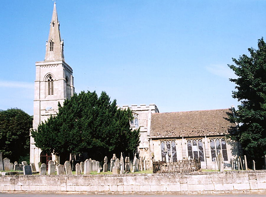
- The Anglican church is dedicated to Saint Michael. (It may be St. Michael and All Angels.)
- The oldest portions of the church appear to be from the 13th century.
- The church was restored in 1859.
- The church seats 290.
- There is a photograph of St. Michael's Church on the Wendy PARKINSON Church Photos web site.
- Richard CROFT has a photograph of St. Michael's Church on Geo-graph, taken in October, 2007.
- Here is a photo of St. Michael's, taken by Ron COLE (who retains the copyright):
- Anglican parish registers exist from 1668, but Bishop's Transcript entries go back to 1561.
- The Lincolnshire Archives have parish register baptisms 1724-1756 on fiche (ref: 13 18 002 01A) and Bishops' Transcripts 1562-1812 on film (ref: MF 4/449, 450). [David Meredith]
- We have the beginning of a parish register extract in a text file. Your additions are welcome.
- The LFHS has published several indexes for the Aveland and Ness Deanery to make your search easier.
- There was a Congregational chapel built here in 1874.
- For information and assistance in researching this chapel, see our non-conformist religions page.
- Check our Church Records page for county-wide resources.
- The parish was in the Deeping sub-district of the Bourne Registration District.
- Check our Civil Registration page for sources and background on Civil Registration which began in July, 1837.
Langtoft is both a village and parish two miles northwest of Market Deeping, 5 miles south of Bourne and 41 miles southeast of Lincoln. The A15 trunk road goes right through the village. Deeping St. Nicholas lies to the northeast. The area is flat fenland, drained by many small canals, including the South Drove Drain.
If you are planning a visit:
- Rodney BURTON has a photograph of the rather distinctive Village Sign on Geo-graph, taken in June, 2007.
- There is bus service from Bourne and Peterborough.
- See our touring page for more sources.
- Ask for a calculation of the distance from Langtoft to another place.
- The old Waggon and Horses Inn burned down in 1888, killing a man who was hit by falling debris.
- Alex McGREGOR has a photograph of the Waggon and Horses pub. on Geo-graph, taken in May, 2019.
- In the east of the village were the remains of a large mansion, supposed to have been the residence of the HYDE family. Anne HYDE married King James II.
- See our Maps page for resources.
You can see maps centred on OS grid reference TF123125 (Lat/Lon: 52.69854, -0.339613), Langtoft which are provided by:
- OpenStreetMap
- Google Maps
- StreetMap (Current Ordnance Survey maps)
- Bing (was Multimap)
- Old Maps Online
- National Library of Scotland (Old Ordnance Survey maps)
- Vision of Britain (Click "Historical units & statistics" for administrative areas.)
- English Jurisdictions in 1851 (Unfortunately the LDS have removed the facility to enable us to specify a starting location, you will need to search yourself on their map.)
- Magic (Geographic information) (Click + on map if it doesn't show)
- GeoHack (Links to on-line maps and location specific services.)
- All places within the same township/parish shown on an Openstreetmap map.
- Nearby townships/parishes shown on an Openstreetmap map.
- Nearby places shown on an Openstreetmap map.
- Matt FASCIONE has a photograph of the War Memorial in the churchyard on Geo-graph, taken in April, 2014.
- The RAF established a Ground Control Intercept (GCI) station here in 1942.
- The equipment was upgraded in the late 1940s and in the 1950s the station was rebuilt as a ROTOR station.
- The station was placed in reserve in March, 1958, and was closed down and sold off some time in the mid 1960s.
- There are photographs and a more detailed history at the Site Records web page.
Michael PECK provides us with: "The names recorded (and there is no indication of which war caused the individual deaths) are as below. There are no ranks or arms of service specified:"
- Harrold AYRE
- Ernest Norman BADGER
- Robert DAY
- Henry FLATTERS
- John FOWLER
- Henry GAY
- William Edward GAY
- James Leonard GOODMAN
- Robert Arthur PLOWRIGHT
- George PORTER
- Ernest THACKER
- Abraham WARN
- Lyn BARBER advises that Ernest THACKER died on 7/1/1943 at age 20 and was buried in Tunisia. He was a gunner in the Royal Artillery.
- See the Langtoft War Memorial site for a list of parishioners who gave their lives in service to their country.
There is one Commonwealth War Grave from World War II in the parish cemetery for:
- Robert Arthur PLOWRIGHT, srgt., RAF 206 Sqdn., age 20, died 1 Jan. 1941. Son of Thomas and Mary E. PLOWRIGHT of Langtoft.
- The name Langtoft is from the Old Scandinavian langr+toft, or "long homestead" and is listed in the 1086 Domesday Book as Langetof.
[A. D. Mills, "A Dictionary of English Place-Names," Oxford University Press, 1991].
- This place was an ancient parish in Lincoln county and became a modern Civil Parish when those were established.
- J. THOMAS has a photograph of the Village Hall on Geo-graph, taken in October, 2013.
- The parish was in the ancient Ness Wapentake in the South Kesteven district and parts of Kesteven
- In April, 1931, this parish gained land from several neighboring Civil Parishes in a boundary re-adjustment. The parish grew from 2,133 acres to 2,915 acres.
- You may contact the local Parish Council regarding civic or political issues, but they are NOT staffed to assist you with family history searches.
- For today's district governance, contact the South Kesteven District Council.
- Bastardy cases were heard in the Bourne petty session hearings on Mondays.
- We have copies of a handful of Langtoft Apprentice papers from the 1800s.
- In 1707, Rachel HYDE left £50 for the poor. The money was used to purchase a small plot of land which was later sold for £450. The money was then used to purchase two houses in Long Sutton which were rented and the rental income distributed to the parish poor.
- In 1820, the Rev. John MOSSOP left a little over 3 acres of land to generate revenue for poor widows of this parish and Baston parish.
- As a result of the 1834 Poor law Amendment Act, this parish became part of the Bourne Poor Law Union.
Ros DUNNING provides a transcript of the will of MOSSUP, John of Langtoft.
Ros DUNNING also provides a transcript of the will of PEASGOOD, Elizabeth of Langtoft.
Ros DUNNING also provides a transcript of the will of ROWBOTTOM, Elizabeth of Langtoft.
- A Public Elementary School was built here in 1859 by Lord Aveland and enlarged in 1875.
- For more on researching school records, see our Schools Research page.