
Hide
North Scarle
hide
Hide
hide
Hide
hide
Hide
Hide
Hide
The Library at Newark will prove useful in your research.
- The church graveyard was closed to further internments before 1913.
- There is a parish cemetery which was administered by the Burial Board of the parish council.
- The parish Cemetery is on South Scarle Lane on the southern edge of the village.
- Richard CROFT has a photograph of the Remembrance Garden on the edge of the Cemetery, on Geo-graph, taken in May, 2006.
- Alan MURRAY-RUST has a photograph of the North Scarle Cemetery on Geo-graph, taken in July, 2012.
| High Street, North Scarle, Cemetery |
- The parish was in the North Collingham sub-district of the Newark Registration District.
- We are accumulating a list of Surnames found in the parish's 1901 census returns.
- Check our Census Resource page for county-wide resources.
- The table below gives census piece numbers, where known:
| Census Year | Piece No. |
|---|---|
| 1841 | H.O. 107 / 622 |
| 1851 | H.O. 107 / 2102 |
| 1861 | R.G. 9 / 2476 |
| 1891 | R.G. 12 / 2711 |
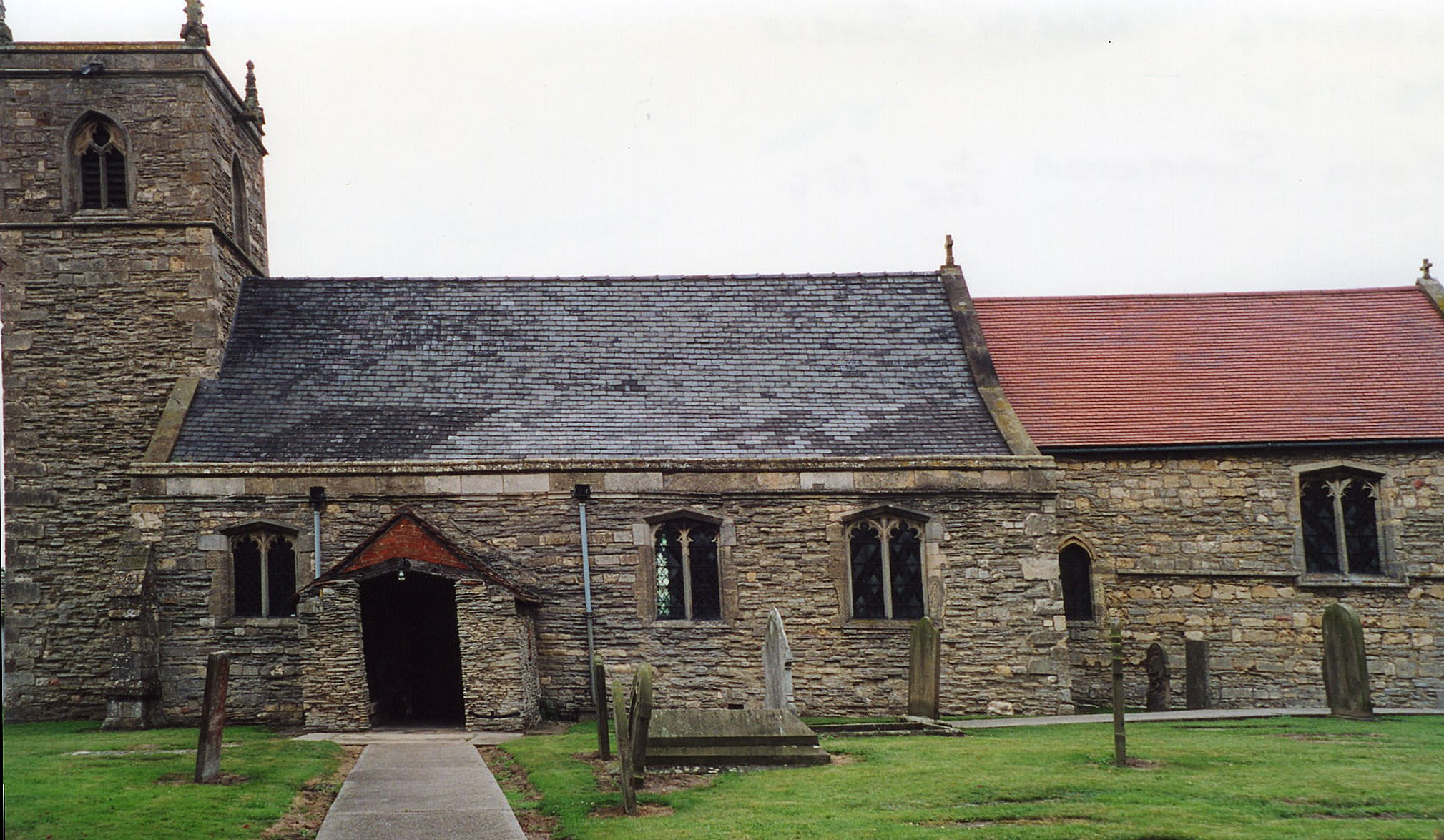
- The Anglican parish church is dedicated to All Saints.
- The church was built after an earlier church was destroyed by fire in 1342. The earlier church structure was probably erected by the Normans.
- The new building underwent partial restorations in 1862, 1874 and 1893.
- A photograph of All Saints Church is at the Wendy PARKINSON English Church Photographs site.
- Richard CROFT has a photograph of All Saints Church on Geo-graph, taken in September, 2006.
- Alan MURRAY-RUST has a photograph of All Saints Church on Geo-graph, taken in July, 2012.
- Here is a photo of All Saints Church, taken by Ron COLE (who retains the copyright):
- The parish register dates from 1571, but Bishop's transcripts go back to 1562.
- Parish registers are on file at the Society of Genealogists, covering 1564 - 1812.
- The LFHS has published several indexes for the Graffoe Deanery to make your search easier.
- North Scarle marriages are in Boyd's Marriage Index, covering 1651 - 1812 and Pallot's Marriage Index, covering 1790 - 1812.
- The parish also had chapels for the Wesleyan Methodists and Wesleyan Reformers. A new Wesleyan chapel was erected in 1901.
- Jonathan THACKER has a photograph of the Methodist Chapel on Geo-graph, taken in January, 2011.
- For information and assistance in researching these chapels, see our non-conformist religions page.
- Check our Church Records page for county-wide resources.
- The parish was in the North Collingham sub-district of the Newark Registration District.
- Check our Civil Registration page for sources and background on Civil Registration which started in July, 1837.
North Scarle parish is approximately 10 miles southwest of Lincoln and the same distance NNE of Newark on Trent. Geographically, the parish is more part of Nottinghamshire, by which it is bordered on three sides, than it is Lincolnshire. Eagle parish borders on the east side. Wigsley and Spafford in Nottinghamshire are to the north. South Scarle, which is also in Nottinghamshire, lies just to the south. The Trent River is about a mile to the west. The parish covers about 2,000 acres.
The village is still small and is perhaps best reached by taking the A1133 south off of the A57 trunk road, then turning east once you reach Girton. If you are planning a visit:
- Equestrian sports are still popular in the area. Visit the Eagle Hall Estate Riding Centre, North Scarle Grange, North Scarle, Lincolnshire, LN6 9ES.
- Fishing is also available at The Poplars. Advance booking required: contact Mr. L. W. Day, The Poplars, Eagle Road, North Scarle, Lincoln.
- While you are there look for the Jubilee plaques. Alan MURRAY-RUST has a photograph of a Jubilee Plaque on Geo-graph, taken in 2012.
- Visit our touring page for more sources.
- Ask for a calculation of the distance from North Scarle to another place.
- Richard CROFT has a photograph of the Heritage Room and post office on Geo-graph, taken in May, 2006.
- See our Maps page for additional resources.
You can see maps centred on OS grid reference SK850669 (Lat/Lon: 53.192404, -0.729232), North Scarle which are provided by:
- OpenStreetMap
- Google Maps
- StreetMap (Current Ordnance Survey maps)
- Bing (was Multimap)
- Old Maps Online
- National Library of Scotland (Old Ordnance Survey maps)
- Vision of Britain (Click "Historical units & statistics" for administrative areas.)
- English Jurisdictions in 1851 (Unfortunately the LDS have removed the facility to enable us to specify a starting location, you will need to search yourself on their map.)
- Magic (Geographic information) (Click + on map if it doesn't show)
- GeoHack (Links to on-line maps and location specific services.)
- All places within the same township/parish shown on an Openstreetmap map.
- Nearby townships/parishes shown on an Openstreetmap map.
- Nearby places shown on an Openstreetmap map.
- Alan MURRAY-RUST has a photograph of the War Memorial inside the churchyard on Geo-graph, taken in July, 2012.
Alan MURRAY-RUST has a photograph of the War Memorial Inscription on Geo-graph, taken in August, 2012.
There is one Commonwealth War Graves in the Cemetery from World War I:
- A. WELLS, priv., 3rd Btn. Leicestershire Regt., age 26, died 2 July 1919. Son of Stephen WELLS.
- The name Scarle is from the Old English scearn, for "mud or dung clearing". In the 1086 Domesday Book it first appears as Scornelei.
[A. D. MILLS, "A Dictionary of English Place-Names," Oxford University Press, 1991]
- This place was an ancient parish in Lincoln county and it became a modern Civil Parish when those were established.
- The parish was in the Low Division the ancient Boothby-Graffoe Wapentake in the North Kesteven district in the parts of Kesteven.
- You may contact the North Scarle Parish Council regarding civic or political matters, but they can NOT help you with family history searches.
- For today's district governance, see the North Kesteven District Council.
- Bastardy cases would be heard in the Lincoln South petty session hearings.
- Care of the poor dates back to at least 1702 when Hugh BADGER donated a house and garden and 15 acres of land for the poor.
- Joseph BANKS added the interest from £100 in 1829.
- After the 1834 Poor Law Amendment Act reforms, the parish became part of the Newark Poor Law Union in 1837.
Year Inhabitants 1801 303 1831 479 1841 483 1851 595 1871 577 1881 515 1891 482 1901 433 1911 447 1921 448 1971 508
- A National School was erected here in 1818 and enlarged in 1854. In the 1870's about 80 children attended. A public elementary school was built in 1876 to replace the older building.
- In 1833, the Reverend Samuel SETTLE gave £20 to the Society for Promoting Christian Knowledge for books and tracts to promote religious education in the parish.
- For more on researching school records, see our Schools Research page.