
Hide
Riby
hide
Hide
hide
Hide
hide
Hide
Hide
hide
Hide
Riby, par. and vil., Lincolnshire, 5½ miles SW. of Great Grimsby, 2,749 ac., pop. 273; P.O.; Riby Grove is the seat of the Tomline family.
From: John BARTHOLOMEW's "Gazetteer of the British Isles (1887)"
Hide
The Caistor Library is an excellent resource with a Local History section and a Family History section.
Alternatively, you can use the Grimsby Library as a resource, also.
- Brian CHESTER has provided a Monument Inscription lookup feature at his website for St. Edmund Church.
- Chris ? has a photograph of several chest tombs in the churchyard on Geo-graph, taken in December, 2014.
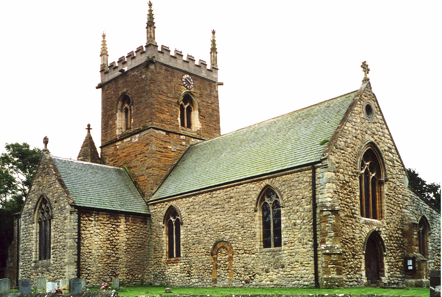
| St Edmund, Riby, Church of England |
- The parish was in the Caistor sub-district of the Caistor Registration District.
- Check our Census Resource page for county-wide resources.
- The table below gives census piece numbers, where known:
| Census Year | Piece No. |
|---|---|
| 1841 | H.O. 107 / 642 |
| 1851 | H.O. 107 / 2114 |
| 1861 | R.G. 9 / 2393 |
| 1871 | R.G. 10 / 3422 |
| 1881 | R.G. 11 / 3280 |
| 1891 | R.G. 12 / 2622 |
| St Edmund, Riby, Church of England |
- The Anglican parish church is dedicated to Saint Edmund.
- The church was originally built in the 12th century.
- The church was rebuilt of stone in 1868, with the exception of the tower.
- The church seats 200.
- A photograph of the Anglican parish church is at the Wendy PARKINSON English Church Photographs site.
- John FIRTH has a photograph of St. Edmund's church on Geo-graph, taken on a June day, 2011.
- Richard CROFT has a fine photograph of church interior on Geo-graph, taken in May, 2010.
- Here is a photo of Saint Edmund's Church, taken by Ron COLE (who retains the copyrights).
- The Anglican parish register dates from 1559.
- The Lincolnshire FHS has published several marriage indexes for the Haverstoe Deanery to make your search easier.
- A Wesleyan Methodist chapel was erected here in 1884.
- Check our Church Records page for county-wide resources.
- The parish was in the Caistor sub-district of the Caistor Registration District.
- Check our Civil Registration page for sources and background on Civil Registration which began in July, 1837.
Riby is a parish and a small village 7 miles north-east of Caistor, 7 miles south of Grimsby and 4 miles south of Stallingborough. The parish covers about 2,800 acres.
If you are planning a visit:
- By automobile, take the A1173 trunk road north-east out of Caistor. Right at the A18 intersection and you will find yourself in Riby.
- See our touring page for visitor services.
- An have an extract from Wilson's 1871 Directory relating to this parish.
- Ask for a calculation of the distance from Riby to another place.
A hoard of 15–20,000 bronze coins dating from Gallienus to Aurelian (AD 253–275) were found in an urn covered by a dish at Riby Wold Farm in 1953.
Henry DUDDING, who was a farmer here in Riby, is known for the development and breeding of the Lincolnshire Longwool Sheep. He was born in Panton, Lincs., in the 1840s and had a farm in Riby in the 1881, 1891 and 1901 census returns. Henry was a churchwarden here for 36 years. He died in December, 1912.
Jill KENNINGTON (born in Riby on 2 January 1943) is a British fashion model and photographer. She grew up on a farm in Riby, with two sisters and a brother. She is best known for her appearance in Michelangelo Antonioni's 1966 film Blow-Up.
- The national grid reference is TA 1807.
- See our Maps page for additional resources.
You can see maps centred on OS grid reference TA183076 (Lat/Lon: 53.551731, -0.215178), Riby which are provided by:
- OpenStreetMap
- Google Maps
- StreetMap (Current Ordnance Survey maps)
- Bing (was Multimap)
- Old Maps Online
- National Library of Scotland (Old Ordnance Survey maps)
- Vision of Britain (Click "Historical units & statistics" for administrative areas.)
- English Jurisdictions in 1851 (Unfortunately the LDS have removed the facility to enable us to specify a starting location, you will need to search yourself on their map.)
- Magic (Geographic information) (Click + on map if it doesn't show)
- GeoHack (Links to on-line maps and location specific services.)
- All places within the same township/parish shown on an Openstreetmap map.
- Nearby townships/parishes shown on an Openstreetmap map.
- Nearby places shown on an Openstreetmap map.
- From "The Stuarts and Commonwealth, Civil War!": "A further siege was planned, but was called off when the Parliamentary troops rebelled, mainly because of discontent over arrears of pay. The Newark raiders extended their activities over a wider area than ever, with successful raids against Riby in Lincolnshire, Rockingham, Torksey House (Lincolnshire) and Barton-upon-Humber."
- From a local bible: "John Harrington Esqr Lieutenant Colonel slain at the Fight at Riby Gap the 18th of June was buried the 19 of the same Month - 1645 in Stallingborough Church. John Mugson a Cavalier wounded at the Fight at Riby Gap was buried the 20 Day of June".
- Kelly's Directory for Lincolnshire for 1885: "An encounter, called "the Battle of Riby Grip," [sic] took place here, June 18, 1645, between the Royalists, under Col. Foster, and a Parliamentary force, under Col. Harrison, in which the latter were routed, and their leader slain; nine soldiers, who also fell, were buried in the churchyard, and Col. Harrison at Stallingborough."
- A grey granite cylindrical column was erected just inside the churchyard as a memorial to the 12 men of the parish who died in World War I. It was unveiled in 1920.
- J. THOMAS has a photograph of the War Memorial on Geo-graph, taken in July, 2014.
- There is also a Roll of Honour mounted in the parish church. It is in a large glazed oak frame with carved details at the outer corners. It has 67 names, of which 55 served and returned.
These are the 12 people listed on the Wa Memroail in the churchyard. All died in WW1.
- Bell, John J., pte. 1st/5th Seaforth Highlanders
- Buckley, Edward, Captain 2nd York and Lancs. Regt.
- Buckley, Roy, 2nd Lt. Manchesters (could not verify military info.)
- Cox, Albert, Sergt Lincs. Regt. (could not verify military info.)
- Goodhand, Fred, pte. 16th Australian Infantry
- Lee, Walter, pte. 1st/5th Lincs. Regt.
- Lee, William Henry, pte. 8th Lincs. Regt.
- Pattinson, Charles H., LCprl. Lincs. Regt.
- Smith, Benjamin, pte. 1st Lincs. Regt.
- Webster, Charles W., pte. Duke of Wellingtons.
- Webster, Fred, gunner RGA
- Wilson, Fred, pte. 7th Lincs. Regt.
- Locals pronounce the name as "RY-bee", not "RIB-ee" according to Pamela BAILLE (2004).
- This place was an ancient parish in Lincolnshire and became a modern Civil Parish when those were established.
- The parish was in the eastern division of the ancient Yarborough Wapentake in the West Lindsey district in the parts of Lindsey.
- Kelly's 1900 Directory of Lincolnshire reports, perhaps erroneously, that the parish was in the North Lindsey division of the county.
- Today's district governance is provided by the West Lindsey District Council.
- Bastardy cases would be heard in the Grimsby Petty Sessional courts.
- As a result of the 1834 Poor Law Amendment Act, the parish became part of the Caistor Poor Law Union.
- In 1848, almshouses were built here for four poor men of the village by Col. G. TOMLINE.
Year Inhabitants 1801 158 1821 168 1831 163 1851 247 1871 222 1881 273 1891 288 1901 248 1911 268 1921 259 1931 248
- A National School was built here in 1890 replacing a village school built in 1848 by the TOMLINE family. It held 60 children.
- For more on researching school records, see our Schools Research page.