
Hide
Swinstead
hide
Hide
hide
Hide
hide
Hide
Hide
Hide
The Library at Bourne should prove useful in your research.
Brian GREEN has a photograph of St. Mary's Churchyard on Geo-graph, taken in January, 2008.
- The parish was in the Corby sub-district of the Bourne Registration District.
- Check our Census Resource page for county-wide resources.
- The table below gives census piece numbers, where known:
| Census Year | Piece No. |
|---|---|
| 1841 | H.O. 107 / 622 |
| 1851 | H.O. 107 / 2095 |
| 1861 | R.G. 9 / 2315 |
| 1871 | R.G. 10 / 3311 |
| 1891 | R.G. 12 / 2555 |
| Swinstead, Methodist (Wesleyan) |
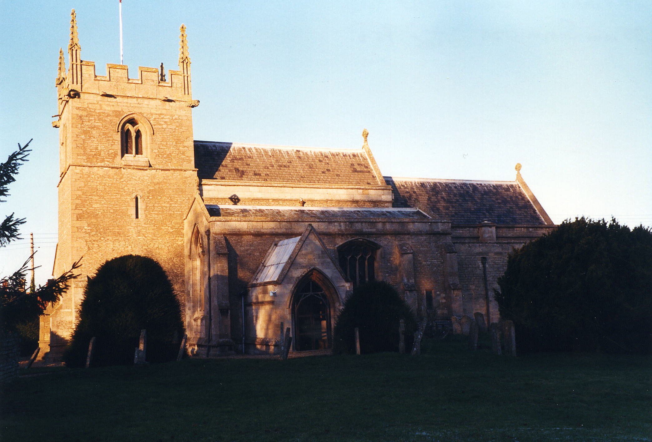
- The Anglican parish church is dedicated to St. Mary.
- The church is built of stone. It was restored in 1854.
- The church seats 250.
- Tim HEATON has a photograph of the Church of St. Mary on Geo-graph, taken in January, 2006.
- Rex NEEDLE also has a photograph of the parish church at Swinstead on Geo-graph, taken in August, 1999.
- Here is a photo of St. Mary's Church, taken by Ron COLE (who retains the copyright):
- Anglican parish registers exist from 1565, although are only deposited for the period 1733 - 1934.
- The Lincolnshire FHS has published several marriage and burial indexes for the Beltisloe Deanery to make your search easier.
- There was a Wesleyan Methodist chapel in the parish. For information and assistance in researching this church, see our non-conformist religions page.
- Check our Church Records page for county-wide resources.
- The parish was in the Corby sub-district of the Bourne Registration District.
- Check our Civil Registration page for sources and background on Civil Registration which began in July, 1837.
Swinstead is both a village and parish which lie just east of the A1 trunk road and south of the A151, 2 miles south-east of Corby. The West Glen River runs along the west boundary of the parish. The parish covers about 1,790 acres.
If you are planning a visit:
- Visit our touring page for more sources.
- Ask for a calculation of the distance from Swinstead to another place.
Rex NEEDLE has a photograph of The Windmill Inn on Geo-graph, taken in January, 2000.
Richard CROFT has a photograph of the remains of the 14th century Market Cross in Swinstead on Geo-graph, taken in March, 2010.
- See our Maps page for additional resources.
You can see maps centred on OS grid reference TF018224 (Lat/Lon: 52.78958, -0.491863), Swinstead which are provided by:
- OpenStreetMap
- Google Maps
- StreetMap (Current Ordnance Survey maps)
- Bing (was Multimap)
- Old Maps Online
- National Library of Scotland (Old Ordnance Survey maps)
- Vision of Britain (Click "Historical units & statistics" for administrative areas.)
- English Jurisdictions in 1851 (Unfortunately the LDS have removed the facility to enable us to specify a starting location, you will need to search yourself on their map.)
- Magic (Geographic information) (Click + on map if it doesn't show)
- GeoHack (Links to on-line maps and location specific services.)
- All places within the same township/parish shown on an Openstreetmap map.
- Nearby townships/parishes shown on an Openstreetmap map.
- Nearby places shown on an Openstreetmap map.
- The Royal Flying Corps established an emergency landing field here in the Great War, but no flight operations were conducted from this field.
- Robert HARVEY has a photograph of St Mary's Church: War Memorial on Geo-graph, taken in January, 2016.
- Robert HARVEY also has a photograph of the Roll of Honour in St. Mary's Church on Geo-graph, taken in January, 2016.
There is one Commonwealth War Grave listed for the churchyard in the CWGC database:
- William PORTER, priv., 14th Btn. Training Reserve, age 18, died 1 Mar. 1917. Son of Ebenezer J. and Alice PORTER of Swinstead.
There are the names on St. Mary's church memorial:
- Corp. Alfred ELLIS
- Lne. Corp. John Henry KING
- Lne. Corp. Henry OSBORN
- Pte. Edward CHAPMAN
- Pte. Edward FOWLER
- Pte. Alfred KETTLE
- Pte. Horace William PICK
- Pte. William PORTER
- Pte. Fred ROSLING
1939 - 1945
- Clarence GENTLES
- Arthur HOLLAND, RASC
- Harold Charles LOUNDS, R.A.
- Alfred SENTENCE, Royal Norf. Regt.
- The name derives from the Old English Swin+ham+stede or "homestead where pigs are kept," and is listed in the 1086 Domesday Book as Suinhamstede.
[A. D. Mills, "A Dictionary of English Place-Names," Oxford University Press, 1991].
- This place was an ancient parish in county Lincoln and became a modern Civil Parish when those were established.
- The parish was in the ancient Beltisloe Wapentake in the South Kesteven district in the parts of Kesteven.
- You can contact the local Parish Council concerning civic or political issues, but they are NOT staffed to assist you with family history searches.
- For today's district governance, contact the South Kesteven District Council.
- Bastardy cases were heard in the Bourne petty session hearings held on Mondays.
- The Common Lands were enclosed here in July of 1778.
- As a result of the 1834 Poor Law Amendment Act, the parish became part of the Bourne Poor Law Union.
Returns from 1086 are from the Domesday Book. 1991 is an estimate.
Year Inhabitants 1086 185 1801 306 1831 402 1841 451 1871 358 1881 349 1891 343 1901 309 1911 299 1991 246
- A Public Elementary School was built here before 1900 to hold 90 children. In 1911, attendance was 60 students.
- For more on researching school records, see our Schools Research page.