
Hide
Thornton le Moor
hide
Hide
hide
Hide
hide
Hide
Hide
hide
Hide
Hide
- The parish was in the Market Rasen sub-district of the Caistor Registration District.
- Check our Census Resource page for county-wide resources.
- The table below gives census piece numbers, where known:
| Census Year | Piece No. |
|---|---|
| 1841 | H.O. 107 / 646 |
| 1861 | R.G. 9 / 2395 |
| 1871 | R.G. 10 / 3425 |
| 1891 | R.G. 12 / 2624 |
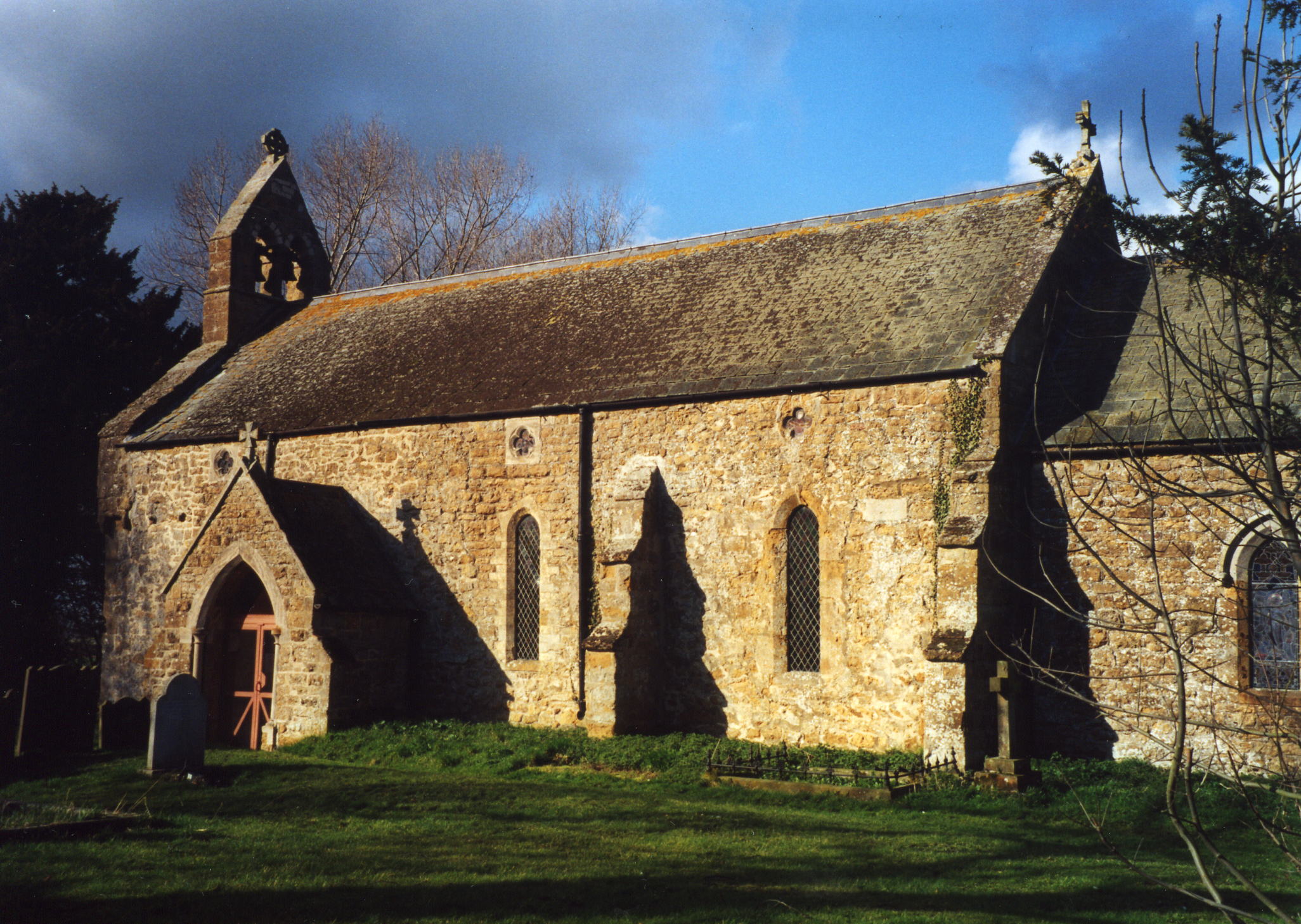
- The Anglican parish church is dedicated to All Saints.
- The age of the church is uncertain, although parts appear to be of Norman origin and there is a Saxon doorway inside. Evidence points to the church existing circa 1100.
- The church was thoroughly restored in 1871.
- The church is a Grade II listed building with English Heritage.
- The church seats 120.
- There is a photograph of All Saints Church on the Wendy PARKINSON Church Photos web site.
- Here is a photo of All Saints church, taken by Ron COLE (who retains the copyright):
- The Anglican parish register dates from 1711.
- The Lincolnshire FHS has published several marriage indexes and a burial index for the Westwold Deanery to make your search easier.
- The parish is often listed as being in the Walshcroft rural deanery in many directories of the county.
- Check our Church Records page for county-wide resources.
- The parish was in the Market Rasen sub-district of the Caistor Registration District.
- Check our Civil Registration page for sources and background on Civil Registration which began in July, 1837.
This small village and parish sits about 7 miles south-west of Caistor on the Ancholme navigation canal. The parish covers about 1,500 acres and includes the ancient hamlet and manor of Bisthorpe (sometimes spelled "Baesthorpe")..
If you are planning a visit:
- By automobile, take the B1205 west out of Caistor past South Kelsey.
- See the Lincolnshire Touring and Holidays page on this site.
- Ask for a calculation of the distance from Thornton le Moor to another place.
- See our Maps page for additional resources.
You can see maps centred on OS grid reference TF050963 (Lat/Lon: 53.452896, -0.420141), Thornton le Moor which are provided by:
- OpenStreetMap
- Google Maps
- StreetMap (Current Ordnance Survey maps)
- Bing (was Multimap)
- Old Maps Online
- National Library of Scotland (Old Ordnance Survey maps)
- Vision of Britain (Click "Historical units & statistics" for administrative areas.)
- English Jurisdictions in 1851 (Unfortunately the LDS have removed the facility to enable us to specify a starting location, you will need to search yourself on their map.)
- Magic (Geographic information) (Click + on map if it doesn't show)
- GeoHack (Links to on-line maps and location specific services.)
- All places within the same township/parish shown on an Openstreetmap map.
- Nearby townships/parishes shown on an Openstreetmap map.
- Nearby places shown on an Openstreetmap map.
- The War Memorial is located inside the church and is a Roll of Honour to those who died and those who served in World War I. See the photograph at Geograph.
- This place was an ancient parish in Lincoln county and became a modern Civil Parish when those were established.
- The parish was in the ancient Walshcroft Wapentake in the West Lindsey district in the parts of Lindsey.
- In April, 1936, this parish was abolished and all 1,533 acres were amalgamated with Owersby Civil Parish.
- Kelly's 1913 Directory of Lincolnshire places the parish, perhaps erroneously, in the East Lindsey division of Lindsey. Others place the parish in the North Lindsey division of the county.
- Today's district governance is provided by the West Lindsey District Council.
- Bastardy cases would be heard on the 1st Tuesday each month at the Market Rasen petty session hearings.
- As a result of the 1834 Poor Law Amendment Act, this parish became part of the Caistor Poor Law Union.
- There is no record of a school here before 1900.
- The children of this parish attended school in North Owersby and South Kelsey.
- For more on researching school records, see our Schools Research page.