
Hide
West Keal
hide
Hide
hide
Hide
hide
Hide
Hide
Hide
- The parish was in the Spilsby sub-district of the Spilsby Registration District.
- Check our Census Resource page for county-wide resources.
- The table below gives census piece numbers, where known:
| Census Year | Piece No. |
|---|---|
| 1841 | H.O. 107 / 638 |
| 1851 | H.O. 107 / 2109 |
| 1861 | R.G. 9 / 2374 |
| 1871 | R.G. 10 / 3392A & 3393A |
| 1891 | R.G. 12 / 2603 |
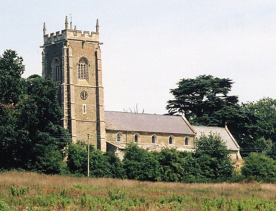
- The Anglican parish church is dedicated to Saint Helen.
- The church was built of green sandstone and brick on a rise above the village in 1623. Part of the church was rebuilt in 1866.
- The church tower fell down on 18 Sep 1881, but was quickly rebuilt and completed in 1884.
- A photograph of Saint Helen's Church is at the Wendy PARKINSON English Church Photographs site.
- Here is a photo of the church, taken by (and copyright of) Norma CLARE.

- Here is a photo of St. Helen's Church, taken by Ron COLE (who retains the copyright):
- The parish register dates from 1625.
- We have a partial Parish Register Extract in a text file which may help some researchers. Your additions are welcome.
- The Lincolnshire FHS has published several marriage indexes and a burial index for the Bolingbroke Deanery to make your search easier.
- Check our Church Records page for county-wide resources.
- The parish was in the Spilsby sub-district of the Spilsby Registration District.
- Check our Civil Registration page for sources and background on Civil Registration which began in July, 1837.
West Keal is a parish southwest of Spilsby and south-east of Horncastle. East Keal parish lies to the east and Stickford parish to the south. The parish covers just over 2,000 acres and includes part of the hamlet of Keal Coates.
If you are considering a visit to the parish:
- Check out our touring page.
- Ask for a calculation of the distance from West Keal to another place.
- See our Maps page for additional resources.
You can see maps centred on OS grid reference TF368634 (Lat/Lon: 53.150065, 0.043774), West Keal which are provided by:
- OpenStreetMap
- Google Maps
- StreetMap (Current Ordnance Survey maps)
- Bing (was Multimap)
- Old Maps Online
- National Library of Scotland (Old Ordnance Survey maps)
- Vision of Britain (Click "Historical units & statistics" for administrative areas.)
- English Jurisdictions in 1851 (Unfortunately the LDS have removed the facility to enable us to specify a starting location, you will need to search yourself on their map.)
- Magic (Geographic information) (Click + on map if it doesn't show)
- GeoHack (Links to on-line maps and location specific services.)
- All places within the same township/parish shown on an Openstreetmap map.
- Nearby townships/parishes shown on an Openstreetmap map.
- Nearby places shown on an Openstreetmap map.
A stone memorial was erected in 1920 for the 17 men from the parish who fell in World War I.
Andrew TELFER porvides a photograph of the West Keal War Memorial at Geo-graph, taken in September, 2005.
For another photograph of the West Keal War Memorial and the names listed for World War I, see the Roll of Honour site.
- In ancient times, this village was called Oustcal, which later became Westerkele and finally West Kiel before its modern name emerged.
- The parish was in the West division of the ancient Bolingbroke Wapentake in the East Lindsey district and parts of Lindsey.
- The parish was also in the Bolingbroke Soke.
- On 24 Dec 1880, small portions of this parish were transferred to Stickford and West Fen parishes.
- You can contact the West Keal Parish Council regarding civic or political matters, but they are NOT staffed or funded to help with your family history searches.
- For today's governance, see the East Lindsey District Council.
- Bastardy cases would be heard in the Spilsby petty session hearings.
- In 1693, John BROWN left £2 per year out of land in Frampton for the parish poor.
- In 1702, John WAYET left 5 shillings per year for the parish poor.
- In 1707, Mary MOWBRAY left 10 shillings per year for the parish poor, as did William DONABY.
- The Common Land was enclosed here in 1774.
- As a result of the 1834 Poor Law Amendment Act, the parish became part of the Spilsby Poor Law Union.
- The Public Elementary School here was built in 1854 to hold 50 children.
- See our Schools page for more information on researching school records.