
Hide
Wrawby cum Brigg
hide
Hide
hide
Hide
hide
Hide
Hide
Wrawby.-- par., township, and vil., Lincolnshire - par. (containing the greater part of Glanford Brigg township), 5070 ac., pop. 2592; township_(partly in town of Brigg), pop. 1264; vil., 1½ mile NE. of Brigg sta.; P.O.
John BARTHOLOMEW, "Gazetteer of the British Isles (1887)"
Hide
The Brigg Library is an excellent resource with a Local History section.
- A cemetery of four acres was formed in 1857. It had two mortuary chapels.
Neil THEASBY has a photograph of St. Mary's Church graveyard on Geo-graph, taken in February, 2017.
- The parish was in the Brigg sub-district of the Glanford Brigg Registration District.
- We have a handful of 1901 census surnames in a text file. Your additions are welcome.
- Check our Census Resource page for county-wide resources.
- The table below gives census piece numbers, where known:
| Census Year | Piece No. |
|---|---|
| 1841 | H.O. 107 / 650 |
| 1851 | H.O. 107 / 2116 |
| 1861 | R.G. 9 / 2398 |
| 1871 | R.G. 10 / 3428 |
| 1881 | R.G. 11 / 3284 |
| 1891 | R.G. 12 / 2625 & 2626 |
| 1901 | R.G. 13 / 1301 |
| Wrawby cum Brigg, Independent |
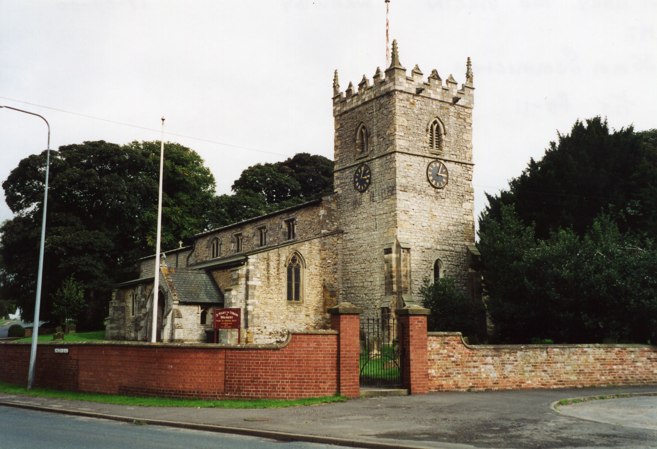
- The Anglican parish church is dedicated to Saint Mary the Virgin.
- The church was restored in 1870.
- The church seats 400 persons.
- David WRIGHT has a photograph of St. Mary's Church on Geo-graph, taken in January, 2006.
- Here is a photo of St. Mary's Church, taken by Ron COLE (who retains the copyright):
- The Anglican parish register dates back to 1675. The earlier registers were destroyed by a fire in 1713. Some earlier entries may be on the Bishop's Transcripts.
- For records prior to 1850, many, many of the records in the Wrawby register were in fact for people living in Brigg [which didn't get its own parish church till the mid 1850s]. Wrawby was a small rural place with no great population, but Brigg at this time was a hugely thriving inland port, absolutely next door to Wrawby, with thousands of ships a year. Many of the Wrawby records are of watermen who travelled the inland water circuits of the county. [Rex Johnson]
- We have a handful of entries in our parish register extract in a text file. Your additions are welcome.
- The Lincolnshire FHS has published several marriage indexes and a burial index for the Yarborough Deanery to make your search easier.
- Over time the parish has hosted several non-conformist chapels. The Wesleyan Methodists and the Independents each had a chapel here. The Wesleyan one was built in 1827. The Primitive methodists followed with one in 1853. The date of the Independent chapel is unknown. For information and assistance in researching these chapels, see our non-conformist religions page.
- Check our Church Records page for county-wide resources.
- The parish was in the Brigg sub-district of the Glanford Brigg Registration District.
- Check our Civil Registration page for sources and background on Civil Registration which began in July, 1837.
Wrawby is both a village and a parish in the north of Lincolnshire, just east of the River Ancholme. The parish lies about 160 miles north of London and a mile north-east of Brigg. The parish is part of the low cars (see our Geographic Names page) or marshes. The parish of Wrawby also incorporates much of the town of Brigg and covers over 3,000 acres.
The village of Wrawby is about three miles east of the old Roman road, Ermine Street, now the A15 trunk road. Kettleby is a hamlet, usually associated with this parish, but actually in the parish of Bigby. If you are planning a visit:
- Take the A18 trunk road east out of Brigg to Wrawby.
- Chris ALLEN has a photograph of a Working post-mill on Geo-graph, taken in June, 1996.
- Visit our touring page for more sources.
- See the version supplied by William Wallworth: Kelly's 1868 Directory.
- Ask for a calculation of the distance from Wrawby cum Brigg to another place.
Chris MORGAN has a photogarph of the Wrawby Postmill on Geo-graph, taken in September, 2019. The description provides some interesting history.
John FIRTH has a photograph of the Black Horse Inn on Geo-graph, taken in June, 2012. At last report, the Inn was closed and looking for new owners.
- See our Maps page for additional resources.
You can see maps centred on OS grid reference TA020086 (Lat/Lon: 53.56411, -0.461431), Wrawby cum Brigg which are provided by:
- OpenStreetMap
- Google Maps
- StreetMap (Current Ordnance Survey maps)
- Bing (was Multimap)
- Old Maps Online
- National Library of Scotland (Old Ordnance Survey maps)
- Vision of Britain (Click "Historical units & statistics" for administrative areas.)
- English Jurisdictions in 1851 (Unfortunately the LDS have removed the facility to enable us to specify a starting location, you will need to search yourself on their map.)
- Magic (Geographic information) (Click + on map if it doesn't show)
- GeoHack (Links to on-line maps and location specific services.)
- All places within the same township/parish shown on an Openstreetmap map.
- Nearby townships/parishes shown on an Openstreetmap map.
- Nearby places shown on an Openstreetmap map.
Ian S. has a phtograph of the First World War Memorial in St. Mary's Church on Geo-graph, taken in March, 2018.
The names on the First World War Memorial in the church are:
- Andrew, Charles Frederick, pte. 8th Bn. Lincs. Regt.
- Andrews, Ellen, sister, TFNS
- Batchelor, A. F.
- Bean, K. F.
- Bean, W. S.
- Cook, F.
- Day, W.
- Hett, Roland Thorston, Lt., RASC
- Nelson, George, Srgt., 6th Bn. Lincs. Regt.
- Scott, T. M.
- Stephenson, A.
- Stephenson, E.
- Vessey, William
- Wilson, W. F.
- Wrawby was also a Township, a different political entity to a parish. In 1892, the part of Wrawby included in the Brigg Urban District was added to Brigg civil parish.
- Due to the creation of Brigg parish, one should also check the Brigg Parish profile.
- The parish was in the ancient Yarborough Wapentake in the Glanford district in the parts of Lindsey.
- The Parish Council meets in the Village Hall early each month.
- District governance is currently provided by the North Lincolnshire Council.
- The poor received 40 shillings yearly, left by Mrs. Helen TRIPP in 1687, out of land at Cadney.
- After the Poor Law Amendment Act of 1834, this parish became part of the Glanford Brigg Poor Law Union.
- Bastardy cases would be heard in the Brigg petty session hearings.
Please note: Any population figures for Wrawby parish may include the inmates and staff of the Poor Law Union workhouse (e.g. 1871).
Year Inhabitants 1801 283 1831 742 1861 1,257 1871 2,631 1881 748 1891 709 1901 703 1911 747 1921 841 1931 830 1951 777 2001 1,293
- The National School was built here in 1842. In 1871 it was attended by about 100 children. This school was enlarged in 1895.
- For more on researching school records, see our Schools Research page.