
Hide
St Katherine Cree-Church
hide
Hide
hide
Hide
Hide
Hide
"ST. CATHERINE, or KATHERINE CREE, the church of, is situated at the south-east angle of Cree church-lane, in Leadenhall-street. [It is] distinguished from other churches of the same name by the addition of Cree, the ancient English method of spelling Christ, as pronounced by the French, having been built on the site of a dissolved priory, whose church was called that of our Saviour Christ. . . The present structure was erected in 1630, it is built of stone in a mixed and impure style. The length of the body is ninety feet, the breadth fifty-one, and the height thirty-seven. Maitland . . . says that the church is a curacy, and that the parishioners have the privilege of electing their own minister, who must be licensed by the Bishop of London. But the Clerical Guide, which must be of authority, says that it is a vicarage, and still in the gift of the Master and Fellows of Magdalene College, Cambridge, who instituted the Rev. George Hodson in 1814." [James Elmes. A Topographical Dictionary of London and its Environs (1831) - transcribed by Brian Randell]
Hide
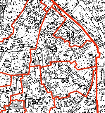
This parish - no. 53 in the above map - is located in Aldgate Ward.
The church dates from before the Great Fire.
Hide
London Metropolitan Archive holdings for St Katherine Cree-Church.
St Katherine Cree - from te Lost City of London blog.
Online Parish Register Images and Indexes for St Katherine Cree-Church parish are provided by, or at various subscription sites via, the FamilySearch wiki.
Non-Church of England denominations identified in St Katherine Cree include: Independent/Congregational, Jewish, and Presbyterian [FamilySearch Wiki].
Wikipedia page on St Katherine Cree-Church.
- Ask for a calculation of the distance from St Katherine Cree-Church to another place.
Summary history of St Katherine Cree-Church parish, from the Worshipful Company of Parish Clerks.
Public Houses, Inns & Taverns of the parish of St Katherine Cree-Church - provides "information from census records, trade directories, etc."
You can see maps centred on OS grid reference TQ334812 (Lat/Lon: 51.513671, -0.078658), St Katherine Cree-Church which are provided by:
- OpenStreetMap
- Google Maps
- StreetMap (Current Ordnance Survey maps)
- Bing (was Multimap)
- Old Maps Online
- National Library of Scotland (Old Ordnance Survey maps)
- Vision of Britain (Click "Historical units & statistics" for administrative areas.)
- English Jurisdictions in 1851 (Unfortunately the LDS have removed the facility to enable us to specify a starting location, you will need to search yourself on their map.)
- Magic (Geographic information) (Click + on map if it doesn't show)
- GeoHack (Links to on-line maps and location specific services.)
- All places within the same township/parish shown on an Openstreetmap map.
- Nearby townships/parishes shown on an Openstreetmap map.
- Nearby places shown on an Openstreetmap map.
Surnames from the 1881 census in the St Katherine Cree-church district.
Clerical career summaries for the parish of St Katherine Cree-Church, from the Clergy of the Church of England Database website.
Sources for listings of taxpayer names for St Katherine Cree-Church parish, listed on the FamilySearch wiki.