
Hide
St Olave Old Jewry
hide
Hide
hide
Hide
Hide
Hide
"ST. OLAVE JEWRY, the church of, stands on the west side of the Old Jewry, is of very ancient foundation, and was originally called St. Olave Upwell, from its patron saint, and the well at the east end in which a pump is now fixed. It was afterwards called Jewry, from its vicinity becoming the allotted residence of the Jews in London. The parish is ancient, and was a rectory, in the gift of the Dean and Chapter of St. Paul's, till about the year 1181. . . After the fire of London the parish of St. Martin Pomary, in Ironmonger-lane, was united to this parish, which being a rectory. . . The ancient church was destroyed by the great fire of 1666, and the present one erected on its site for the united parishes by Sir Christopher Wren. It was began in 1673, and finished in 1676, and is a plain neat, church of brick, with stone dressings, to the doors and windows. The united parishes are as before-mentioned, a vicarage and rectory, in the patronage of the crown, and in the city, diocese and archdeaconry of London. Its present rector and vicar is the Rev. Robert Hamilton, D.D., who was instituted by the Lord Chancellor in 1797." [James Elmes. A Topographical Dictionary of London and its Environs (1831) - transcribed by Brian Randell]
Hide
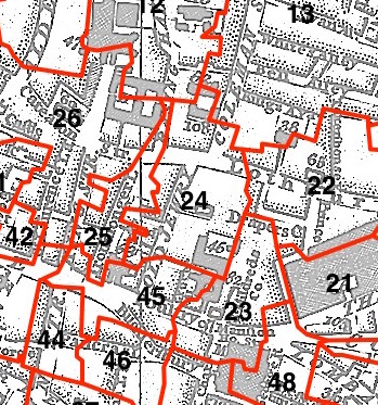
This parish - no. 24 in the above map - is located in Coleman Street Ward.
The church was destroyed in 1666, rebuilt by Wren 1670-6, was demolished in 1888-1891 except for the tower.
The parish was later united with St Margaret Lothbury 1886.
Hide
London Metropolitan Archive holdings for St Olave Old Jewry.
Online Parish Register Images and Indexes for St Olave Old Jewry parish are provided by, or at various subscription sites via, the LDS FamilySearch wiki.
Presbyterian is the only identified non-Church of England denomination in St Olave Old Jewry with St Martin Pomeroy [LDS FamilySearch Wiki].
Wikipedia page on St Olave Old Jewry.
- Ask for a calculation of the distance from St Olave Old Jewry to another place.
Summary history of St Olave Old Jewry parish, from the Worshipful Company of Parish Clerks.
Public Houses, Inns & Taverns of the parish of St Olave Old Jewry - provides "information from census records, trade directories, etc."
Plan of the Parish of St Olave Old Jewry in c1881 from COLLAGE, the London Picture Archive.
1775 map of St Olave Old Jewry, St Martin Pomery - illustration of the location covered by the map, and of archive(s) holding a copy, provided by the Catalogue of British Town Maps.
You can see maps centred on OS grid reference TQ326813 (Lat/Lon: 51.514659, -0.09076), St Olave Old Jewry which are provided by:
- OpenStreetMap
- Google Maps
- StreetMap (Current Ordnance Survey maps)
- Bing (was Multimap)
- Old Maps Online
- National Library of Scotland (Old Ordnance Survey maps)
- Vision of Britain (Click "Historical units & statistics" for administrative areas.)
- English Jurisdictions in 1851 (Unfortunately the LDS have removed the facility to enable us to specify a starting location, you will need to search yourself on their map.)
- Magic (Geographic information) (Click + on map if it doesn't show)
- GeoHack (Links to on-line maps and location specific services.)
- All places within the same township/parish shown on an Openstreetmap map.
- Nearby townships/parishes shown on an Openstreetmap map.
- Nearby places shown on an Openstreetmap map.
Surnames from the 1881 census in the St Olave Old Jewry and St Olave Old Jewry London districts.
Clerical career summaries for the parish of (i) St Olave Old Jewry and (ii) St Olave Old Jewry With St Martin Pomeroy, from the Clergy of the Church of England Database website.
Sources for listings of taxpayer names for St Olave Old Jewry parish, listed on the LDS FamilySearch wiki.