
Hide
Falstone
hide
Hide
hide
Hide
Hide
Hide
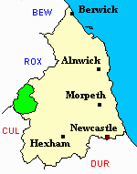
"FALSTONE is a parish comprising the townships of Plawshets and Wellbaugh. It extends eastward from the limits of Cumberland and Scotland, to the parishes of Thorneyburn and Greystead, a distance of eleven miles, and comprises an area of 57,700 acres. The population in 1801, was 437; in 1811 429; in 1821, 50l; in 1831, 521; in 1841, 560; and in 1851, 562 souls. This extensive parish is one of those into which the parish of Simonburn was divided by act of parliament in 1811. It is a moorish and mountainous district, on which great numbers of sheep are pastured; grouse, partridge, and black game are found in abundance. The North Tyne rises in this parish, and here receives a number of burns or rivulets, on whose banks the soil is in many places well cultivated. From the source of the North Tyne to Bellingham, there are numerous traces of the castramentations, or strongholds, of the ancient Britons. We may mention Bell's Hunkin, and Ryan's Hill, one mile above Keilder Castle; Hitchill Wood, and Camp Rigg, near Keilder; Lowey Knough, and Hobb's Knough, about a mile from the last named place; Harpney Rigg, and Baresdales, on the Lewis-burn, and Hawk's Knough. There is also one on Wellhaugh Moor, another in a wood near Eals, and a third on Knopping Holme Hill, opposite to Tarset Castle. The name of Falstone is said to be a corruption of the Anglo-Saxon word Fæston, signifying a stronghold for the purpose of fastening or securing cattle, &c." [From History, Topography, and Directory of Northumberland, Whellan, 1855].
Hide
- Some fascinating early 20th century photographs of the North Tyne area have been published in:- "North Tyneside Traveller 1912-1937 - The Photographs of W.P. Collier of Bellingham" edited by S.F.Owen and published in 1998 by The Heritage Centre, Bellingham, Northumberland, NE48 2AU
- Burial Registers 1911-1959 and Grave Space Plans 1911 for Falstone Civil Cemetery are available at Northumberland Record Office
- Northumberland County Record Office holds copies of Census Returns 1841 - 1891 and provides a useful User Guide
- The 1851 Census Index (microfiche CN20) Falstone, Thorneyburn, Greystead, Bellingham, Corsenbridge, Wark, Thockrington, Kirkharle, Elsdon (part), Kirkwhelpington and Birtley (PRO piece HO107/2417 folios 1-292) (Type A) (Book) published by the https://www.ndfhs.org.uk/ may be of value to researchers interested in this parish.
- Bell's Chapel or Bell's Kirk - is mentioned in Parson and White's 1828 Directory:-
"At the junction of the Dead Water and Bell's-bourne, 2 miles WNW of Kielder Castle, stood Bell's chapel, but every vestige of it has long been obliterated, except some graves".
Roy Perkins has supplied further information on this enigmatic place:-"In the Deadwater area of Falstone Parish stood Bell's Kirk at about map reference NY617949. Little is known of this chapel and no registers appear to be extant. The name is probably a corruption of Beltaine and the Beltaine Stones would probably have stood nearby. Thus it is likely to have been originally a pagan site which was gradually adopted. There is some evidence that a village of Bell stood nearby at an earlier date, and the population was certainly much greater years ago, hence the village and Chapel of Wyel just over the Roxburghshire border."
- The Ancestral Indexes website provides information about Falstone, St Peter.
- Falstone - Church Records - links and information.
- This area is within Northumberland West Registration District.
- Certificates of birth, death and marriage can be ordered from Northumberland County Council.
- Photographs of Falstone and Kielder Reservoir from Les Bell's Northumberland Cam website.
- The Northumberland Communities website includes pages relating to Falstone and Kielder. They provide "a range of learning resource material that reflects Northumberland's heritage, providing a base for studying the County's history. The website provides a starting point for understanding the development of communities in Northumberland. It also seeks to illustrate the range of sources for family and local history research that are available via Northumberland Archives Service."
- The section of The National Gazetteer (1868) relating to this parish - transcribed by Colin Hinson.
- Ask for a calculation of the distance from Falstone to another place.
- A history of the village of Falstone from the Northumberland National Park website.
- The history of Falstone Parish is included in:- Northumberland County History Committee, History of Northumberland, Volume 15. Newcastle, A. Reid, 1940. (Available on fiche from Ancestral Indexes).
- Falstone - Maps - links and information.
You can see maps centred on OS grid reference NY652922 (Lat/Lon: 55.222802, -2.547971), Falstone which are provided by:
- OpenStreetMap
- Google Maps
- StreetMap (Current Ordnance Survey maps)
- Bing (was Multimap)
- Old Maps Online
- National Library of Scotland (Old Ordnance Survey maps)
- Vision of Britain (Click "Historical units & statistics" for administrative areas.)
- English Jurisdictions in 1851 (Unfortunately the LDS have removed the facility to enable us to specify a starting location, you will need to search yourself on their map.)
- Magic (Geographic information) (Click + on map if it doesn't show)
- GeoHack (Links to on-line maps and location specific services.)
- All places within the same township/parish shown on an Openstreetmap map.
- Nearby townships/parishes shown on an Openstreetmap map.
- Nearby places shown on an Openstreetmap map.