
Hide
Cley next the Sea
hide
Hide
hide
Hide
hide
Hide
Hide
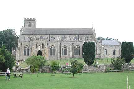
"CLEY-NEXT-THE-SEA is a small town and port, on the river Glaven, about 1 mile from the beach, 8 miles W. of Wells, 4½ miles N.N.W. of Holt, and 25 miles N.N.W. of Norwich. Its parish has increased its population since 1801, from 547 to 828 souls, and contains 2167A. of land, a great part of which is salt marsh. W.H.C. Hardy, Esq., is lord of the manor, and owner of a great part of the soil. Cley had formerly a small market on Saturday, and has still a pleasure fair on the last Friday and Saturday in July. The harbour is very narrow and shallow, but in its course to the sea it forms a junction with the Blakeney channel. The CUSTOM HOUSE for the Port of Blakeney and Cley, (including Cromer and several fishing towns,) is situated here . . . . Cley CHURCH (St. Margaret,) is a handsome Gothic edifice, with a square tower, supposed to have been built in the reign of Henry VI. . . . The rectory, valued in the King's Book at £22. 13s. 4d., has 17A. of glebe, but no parsonage. The trustees of the late J.W. Tomlinson, Esq., are patrons, and the Rev. Chas. Codd, B.A., is the incumbent." [William White, History, Gazetteer, and Directory of Norfolk (1845) - Transcription copyright © Pat Newby]
Hide
Cley next the Sea is also known as Cley and as Clay.
See also Cockley Cley.
Hide
- The Monumental Inscriptions in the Hundred of Holt (Walter Rye).
- The parishes covered include Cley.
See Thornage
See also Norfolk Parish Links: Cemeteries
- 1891: Surname List (this is a link to an archived copy)
See also Norfolk Parish Links: Censuses
- In 1883 the parish was in the Deanery of Holt, in the archdeaconry of Norwich.
It could have been in a different deanery or archdeaconry both before and after this date. - The parish church is dedicated to St Margaret.
- Church of St Margaret
- Description, history, incumbents, pictures, etc.
- Church of St Margaret
- Description and pictures.
- Church of St Margaret
- Services, etc.
- Church of St Margaret
- Picture of the church.
- Cozens-Hardy, Basil
- A short history of St Margaret's Church, Cley-next-the-Sea.
[Holt, Rounce and Wortley, 1928] - Linnell, Charles Lawrence Scruton
- St Margaret's Church, Cley-Next-The-Sea.
[London, Home Words, 1959] - Linnell, Charles Lawrence Scruton
- The brasses at Cley-next-the-Sea, Norfolk.
[Monumental Brass Society Transactions, vol.8, part.5, 1947] - Micklethwaite, J.T.
- A note on the Church of Cley.
[Norwich, Norfolk and Norwich Archaeological Society, in "Norfolk Archaeology", vol.15, 1904] - Rose, Edwin J.; and Pooley, Graham
- A medieval wallpainting from Cley-next-the-Sea.
[Norwich, Norfolk and Norwich Archaeological Society, in "Norfolk Archaeology", vol.37, 1980]
- Marriages
- These are not included in Boyd's Marriage Index or Phillimore's Marriage Registers.
See also Norfolk Parish Links: Church Records
For the civil registration of births, marriages and deaths between 1837 and 1930 (and for the censuses from 1851 to 1901), Cley was in Erpingham Registration District.
- Cley
- Description, pictures, parish council, etc.
- Buttercup Joe
- The 1953 floods at Cley, Salthouse and Blakeney.
[Buttercup Publishing, 1992] - Buttercup Joe
- Buttercup's war at Cley-next-the-Sea, 1931-1945.
[1993] - Starr, Freda
- Cley village memories.
[Blakeney, Red House Books, 1989] - Starr, Freda
- Some old Cley characters.
[Blakeney, Red House Books, 1992] - Starr, Freda
- A village shop.
[ISBN 0947681558, Cley-next-the-Sea, Anglia Television Bygones, 1994] - Stephenson, Frank
- The story of Cley-next-the-sea, with a brief commentary on the church of St Margaret.
[Blakeney, The Maritime Boatshop, 1977] - Cley Post Mill
- Description and map.
- Cley Tower Mill
- Description, history and pictures.
- No author
- Blakeney Langham Morston Cley Wiveton: Festival year 1951.
(Festival of Britain 1951)
[ISBN 0951832816, 1951?]
- 1845: White's History, Gazetteer, and Directory of Norfolk
- 1854: White's History, Gazetteer, and Directory of Norfolk (this is a link to an archived copy)
- 1883: White's History, Gazetteer, and Directory of Norfolk
- 1883: Kelly's Directory for Cambridgeshire, Norfolk and Suffolk (this is a link to an archived copy)
See also Norfolk Parish Links: Directories
- Ask for a calculation of the distance from Cley next the Sea to another place.
Cley is in Holt Hundred.
- Parish outline and location.
- See Parish Map for Holt Hundred
- Description of Holt Hundred
- 1845: White's History, Gazetteer, and Directory of Norfolk
- Brooks, Peter F.
- Cley: Living with memories of greatness.
[ISBN 0946148074, North Walsham, Poppyland Publishing, 1988] - Cozens-Hardy, Basil
- The maritime trade of the port of Blakeney, which included Cley and Wiveton, 1587-1590.
[Norwich, Norfolk Record Society, vol.8, 1936] - Harrison, Carey
- Cley.
[ISBN 0434313688, London, Heinemann, 1991] - Hooton, Jonathan
- The maritime trade and decline of the port of Blakeney and Cley, 1500-1900.
[Norwich, 1973] - Hooton, Jonathan
- The Glaven Ports: A maritime history of Blakeney, Cley and Wiveton, in north Norfolk.
[ISBN 0951832816, Blakeney, Blakeney History Group, 1996] - Longcroft, Adam
- Fire damage in a rural community: the case of Cley-next-the-sea.
[Vernacular Architecture, vol.26, 1995] - Mellor, Derick
- The Glaven Valley: Historical Jottings.
[Cromer, Cheverton and Son, 1989] - Mellor, Derick
- The Glaven Valley: Further Historical Jottings.
(Compiled by Marjorie Missen).
[Blakeney?, 1994]
- Great Britain: Statute
- Cley Inclosure Act, 1821.
An act for inclosing lands in the parish of Cley-next-the-Sea, in the county of Norfolk, and for embanking and draining parts of the said lands, and lands in the parish of Wiveton in the said county.
[London, George Eyre and Andrew Strahan, 1821] - Inclosure
- See also Field Dalling
You can see maps centred on OS grid reference TG046438 (Lat/Lon: 52.952361, 1.043957), Cley next the Sea which are provided by:
- OpenStreetMap
- Google Maps
- StreetMap (Current Ordnance Survey maps)
- Bing (was Multimap)
- Old Maps Online
- National Library of Scotland (Old Ordnance Survey maps)
- Vision of Britain (Click "Historical units & statistics" for administrative areas.)
- English Jurisdictions in 1851 (Unfortunately the LDS have removed the facility to enable us to specify a starting location, you will need to search yourself on their map.)
- Magic (Geographic information) (Click + on map if it doesn't show)
- GeoHack (Links to on-line maps and location specific services.)
- All places within the same township/parish shown on an Openstreetmap map.
- Nearby townships/parishes shown on an Openstreetmap map.
- Nearby places shown on an Openstreetmap map.
- Roll of Honour
- World Wars 1 and 2.
- After 1834 Cley became part of the Erpingham Union, and the workhouses were at Gimingham and Sheringham. These were replaced by a new workhouse at West Beckham in 1850.
These figures are from the population tables which were produced after the 10-yearly national censuses. The "Families" heading includes families and single occupiers.
|
|
There may be more people living in detached parts of the parish (if there were any) and, if so, the number may or may not be included in the figures above. It is quite difficult to be sure from the population tables.
- 1851 Census
- "About 60 persons dwelling in Salthouse, and about 120 in Cley-next-the-Sea were only temporarily in those Parishes, in consequence of the works of the Salthouse Inclosure and Embankment in progress."
- 1861 Census
- "The decrease of population in the parishes of Weybourne, Salthouse, and Cley-next-the-Sea is attributed to the fact that the return for 1851 included a large number of labourers who were engaged in embanking a tract of marsh land."
- 1901 Census
- "Including Newgate."