
Hide
Garvestone
hide
Hide
hide
Hide
hide
Hide
Hide
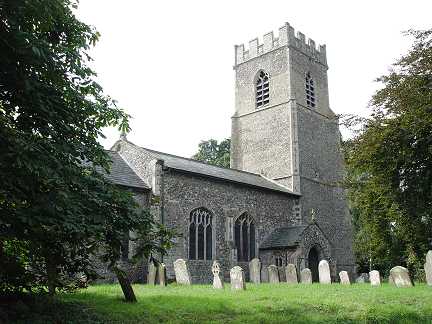
" GARVESTON, commonly called Garston, is a small village and parish, on the Hingham road, 5 miles S.S.E. of East Dereham, comprising only 386 inhabitants, and about 800 acres of land. Edw. Lombe, Esq., is lord of the manor, but the soil belongs mostly to Sir W. R. Clayton, and other freeholders. "The right of lord of this manor was decided in the time of King Edward, by the tenants in single combat." The CHURCH, dedicated to St. Margaret, has a very ancient carved font, and four bells. The living is a discharged rectory, valued in K.B. at £7. 16., and in 1831, at £190. The tithes have been commuted for £243 per annum. Sir Wm. Robt. Clayton, Bart., is the patron, and the Rev. A.P. Clayton, M.A., of Berkshire, is the incumbent, for whom the Rev. A. Wodehouse, officiates." [William White, History, Gazetteer, and Directory of Norfolk (1845) - Transcription copyright © Mike Bristow]
Hide
Garveston is about 7 miles N.W. of Wymondham.
The name may also be spelled Garvestone.
Hide
- 1861
- 1891: Surname List (this is a link an archived copy)
See also Norfolk Parish Links: Censuses
- In 1883 the parish was in the Deanery of Hingham, in the archdeaconry of Norfolk.
- The parish church is dedicated to St Margaret.
- Church of St Margaret
- Description and pictures.
- Church of St Margaret
- Services, etc.
- Church of St Margaret
- Picture of the church.
- Methodist Church
- Minister, services, picture, etc.
Follow the link to the home page, then search for the church.
- Campling, Arthur
- Index of Baptisms, Garveston, 1538-1676, 1712-1812.
[Norwich Local Studies Library, Handwritten document, 1930s] - Campling, Arthur
- Index of Marriages, Garveston, 1538-1676, 1712-1812.
[Norwich Local Studies Library, Handwritten document, 1930s] - Campling, Arthur
- Index of Burials, Garveston, 1561-1676.
[Norwich Local Studies Library, Handwritten document, 1930s] - Parish Register Transcripts
- Marriages.
- Marriages
- These are not included in Boyd's Marriage Index or Phillimore's Marriage Registers.
See also Norfolk Parish Links: Church Records
For the civil registration of births, marriages and deaths between 1837 and 1930 (and for the censuses from 1851 to 1901), Garveston was in Mitford and Launditch Registration District.
- Garvestone, Reymerston and Thuxton Parish Council
- Councillors, etc.
- Garveston Post Mill
- Description, history and map.
- 1845: White's History, Gazetteer, and Directory of Norfolk
- 1850: Hunt's Directory of East Norfolk with Part of Suffolk
- 1854: White's History, Gazetteer, and Directory of Norfolk (this is a link to an archived copy)
- 1883: White's History, Gazetteer, and Directory of Norfolk
- 1883: Kelly's Directory for Cambridgeshire, Norfolk and Suffolk (this is a link to an archived copy)
See also Norfolk Parish Links: Directories
- Ask for a calculation of the distance from Garvestone to another place.
Garveston is in Mitford hundred.
- Inclosure
- See Westfield
You can see maps centred on OS grid reference TG025076 (Lat/Lon: 52.628479, 0.990313), Garvestone which are provided by:
- OpenStreetMap
- Google Maps
- StreetMap (Current Ordnance Survey maps)
- Bing (was Multimap)
- Old Maps Online
- National Library of Scotland (Old Ordnance Survey maps)
- Vision of Britain (Click "Historical units & statistics" for administrative areas.)
- English Jurisdictions in 1851 (Unfortunately the LDS have removed the facility to enable us to specify a starting location, you will need to search yourself on their map.)
- Magic (Geographic information) (Click + on map if it doesn't show)
- GeoHack (Links to on-line maps and location specific services.)
- All places within the same township/parish shown on an Openstreetmap map.
- Nearby townships/parishes shown on an Openstreetmap map.
- Nearby places shown on an Openstreetmap map.
- Roll of Honour
- World Wars 1 and 2.
- After 1834 Garveston became part of the Mitford and Launditch Union, and the workhouse was at Gressenhall.
These figures are from the population tables which were produced after the 10-yearly national censuses. The "Families" heading includes families and single occupiers.
|
|
There may be more people living in detached parts of the parish (if there were any) and, if so, the number may or may not be included in the figures above. It is quite difficult to be sure from the population tables.
- 1861 Census
- MITFORD. The decrease of population in most of the parishes comprised in the Mitford District is attributed to the migration of labourers to towns, and to Yorkshire and Northumberland, &c."