
Hide
Helhoughton
hide
Hide
hide
Hide
hide
Hide
Hide
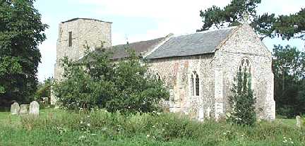
"HELOUGHTON, a pleasant village, in a valley, 5 miles S.W. by W. of Fakenham, has in its parish 356 inhabitants, and 1,638 acres of land, mostly the property of Lord Chas. Vere Ferrars Townshend, the lord of the manor, impropriator of the great tithes, and patron of the vicarage, valued in the King's Book at £6 13s. 4d., and in 1831 at £258, with that of South Rainham annexed to it, in the incumbency of the Rev. Arthur Loftus, of Fincham. The CHURCH (All Saints,) has a nave, chancel, and tower." [William White, History, Gazetteer, and Directory of Norfolk (1845) - Transcription copyright © Pat Newby]
Hide
The name may also be spelled Heloughton or Hellhoughton.
See also Houghton, Houghton on the Hill and Houghton St Giles.
Hide
| Cemetery, Helhoughton, Cemetery |
- 1891: Surname List (this is a link to an archived copy)
See also Norfolk Parish Links: Censuses
| Cemetery, Helhoughton, Cemetery |
| Chapel, Helhoughton, Primitive Methodist |
- In 1883 the parish was in the Deanery of Toftrees, in the archdeaconry of Norwich.
It could have been in a different deanery or archdeaconry both before and after this date. - The parish church is dedicated to All Saints.
- Church of All Saints
- Description and pictures.
- Church of All Saints
- Minister, services, location, etc.
- Church of All Saints
- Picture of the church.
- Parish Register Transcripts
- Baptisms 1813-1880
- Helhoughton Marriages 1539-1837
- See Phillimore's Marriage Registers, Volume 8.
- Marriages
- These are included in Boyd's Marriage Index.
- Parish Registers
- List of Surnames of People who come from other Parishes
(these people are often known as "Strays") - Clergy of the Church of All Saints
- 1312-1905
See also Norfolk Parish Links: Church Records
For the civil registration of births, marriages and deaths between 1837 and 1930 (and for the censuses from 1851 to 1901), Helhoughton was in Walsingham Registration District.
- 1845: White's History, Gazetteer, and Directory of Norfolk
- 1854: White's History, Gazetteer, and Directory of Norfolk (this is a link to an archived copy)
- 1883: White's History, Gazetteer, and Directory of Norfolk
- 1883: Kelly's Directory for Cambridgeshire, Norfolk and Suffolk (this is a link to an archived copy)
See also Norfolk Parish Links: Directories
- Ask for a calculation of the distance from Helhoughton to another place.
Helhoughton is in Gallow Hundred.
- Parish outline and location.
- See Parish Map for Gallow Hundred
- Description of Gallow Hundred
- 1845: White's History, Gazetteer, and Directory of Norfolk
- Inclosure
- See East Rudham.
You can see maps centred on OS grid reference TF868265 (Lat/Lon: 52.804111, 0.769384), Helhoughton which are provided by:
- OpenStreetMap
- Google Maps
- StreetMap (Current Ordnance Survey maps)
- Bing (was Multimap)
- Old Maps Online
- National Library of Scotland (Old Ordnance Survey maps)
- Vision of Britain (Click "Historical units & statistics" for administrative areas.)
- English Jurisdictions in 1851 (Unfortunately the LDS have removed the facility to enable us to specify a starting location, you will need to search yourself on their map.)
- Magic (Geographic information) (Click + on map if it doesn't show)
- GeoHack (Links to on-line maps and location specific services.)
- All places within the same township/parish shown on an Openstreetmap map.
- Nearby townships/parishes shown on an Openstreetmap map.
- Nearby places shown on an Openstreetmap map.
- After 1834 Helhoughton became part of the Walsingham Union, and the workhouse was at Great Snoring.
These figures are from the population tables which were produced after the 10-yearly national censuses. The "Families" heading includes families and single occupiers.
|
|
There may be more people living in detached parts of the parish (if there were any) and, if so, the number may or may not be included in the figures above. It is quite difficult to be sure from the population tables.