
Hide
North Wheatley
hide
Hide
hide
Hide
hide
Hide
Hide
"North Wheatley is a considerable village and parish on a steep declivity on the Gainsborough Road, five miles north-east from Retford, and five miles south-west from Gainsborough. The parish contains 427 inhabitants and 2,538 acres of land. Lord Middleton is principal owner. John Mee Esq. (Retford), John Nettleship Esq. (Tickhill) and several others have estates, besides several resident owners. Lord Wenlock is lord of the manor, which is mostly on copyhold tenure, paying a fine on the death or change of tenant, equal to one and a half years rent. William Heaton Esq. of Gainsborough is steward of the manor, and courts are held annually in May and November. At The Domesday Survey, part of Wateley was a berne of the Archbishop of York's soke of Laneham, and the rest belonged to the King's soke of Mansfield, and was of the fee of Roger de Busli.
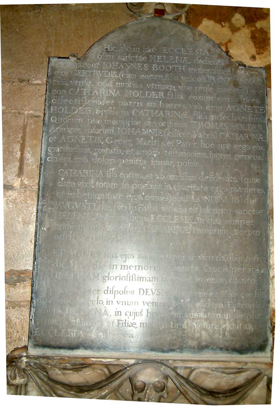
The church, dedicated to St Peter, appears to have been erected in the 16th century. It has a tower with five bells, but the chancel was rebuilt in 1824. Lord Middleton is patron, and has also the impropriation of two-thirds of the great tithes, but the other third belongs to the vicarage, which was valued in the King's books at £3 18s 10½d, now £246, and is enjoyed by the Rev. Charles Walter Hudson.
The open fields were enclosed under an act passed in 1837, and the tithe was commuted in 1838 for £620, of which £370 was apportioned to Lord Middleton as impropriator, and £250 to the vicar. The Rector of Clayworth received the tithe from 59 acres of land in the parish. The Methodists have a neat chapel, erected in 1836, and a National School was erected in 1826 by the Rev. F. Hewgill, at that time vicar. A feast and a hiring for servants is held on the second Thursday in November, when the green is crowded with visitors."
[WHITE's "Directory of Nottinghamshire." 1853]
Hide
The Worksop Library will prove useful in your research.
And the Gainsborough Library would be another good resource.
- The parish was in the Gringley sub-district of the East Retford Registration District.
- The table below gives census piece numbers, where known:
| Census Year | Piece No. |
|---|---|
| 1841 | H.O. 107 / 852 |
| 1861 | R.G. 9 / 2412 |
| 1871 | R.G. 10 / 3450 |
| 1881 | R.G. 11 / 3299 |
| 1891 | R.G. 12 / 2638 |
- The Anglican parish church is dedicated to Saint Peter and Saint Paul.
- The church was built in the 16th century.
- The old Norman church chancel was taken down in 1824 and the present one built in 1825.
- The churchyard was closed in May, 1879. Later burials were in South Wheatley.
- The church was restored in 1896.
- Richard CROFT has a photograph of St. Peter & St. Paul's Church on Geo-graph, taken in November 2005.
- Alan MURRAY-RUST has a fine photograph of the Church tower on Geo-graph, taken in September, 2014.
- The Anglican parish register dates from 1649.
- The church was in the rural deanery #1 of Retford.
- The Wesleyan Methodists had a chapel built here in 1836.
- John SLATER has a photograph of the Wesleyan Methodist chapel on Geo-graph, taken in February, 2016.
- The Primitive Methodists had a chapel here before 1881.
- The parish was in the Gringley sub-district of the East Retford Registration District.
- Civil Registration began in July, 1837.
North Wheatley is both a village and a parish about 5 miles north-east of East Retford, 5 miles south-west of Gainsborough in Lincolnshire and 146 miles north of London. The parish covers almost 2,200 acres.
If you are planning a visit:
- The Wheatley Beck separates North Wheatley from South Wheatley.
- By automobile, take the A1 motorway north to West Drayton, take the A634 north to Retford, then take the A620 trunk road to the north-east. You'll find North Wheatley after only five miles travel on the A620. The A620 bypass around Wheatley passes adjacent to the village on the north side and was built in 1950.
- There is no rail service to North Wheatley.
- Graham HOGG ha s a photograph of the Village Sign on Geo-graph, taken in January, 2015.
- We have an extract from White's 1853 Directory relating to this parish.
- Ask for a calculation of the distance from North Wheatley to another place.
Richard CROFT has a photograph of the old Roman Road, now Haughgate Hill, on Geo-graph, taken in September, 2010.
John SLATER has a photograph of the Sun Inn on Geo-graph, taken in February, 2016.
Alan MURRAY-RUST has a photograph of the former Old Plough public house on Geo-graph, taken in September, 2014. It is now a private residence.
- The Old Hall on Low Street is dated 1673 and bears the arms of the CARTWRIGHT family.
- Alan MURRAY-RUST has a photograph of the Old Hall on Geo-graph, taken in September, 2014.
- See our Maps page for additional resources.
You can see maps centred on OS grid reference SK761858 (Lat/Lon: 53.363603, -0.857892), North Wheatley which are provided by:
- OpenStreetMap
- Google Maps
- StreetMap (Current Ordnance Survey maps)
- Bing (was Multimap)
- Old Maps Online
- National Library of Scotland (Old Ordnance Survey maps)
- Vision of Britain (Click "Historical units & statistics" for administrative areas.)
- English Jurisdictions in 1851 (Unfortunately the LDS have removed the facility to enable us to specify a starting location, you will need to search yourself on their map.)
- Magic (Geographic information) (Click + on map if it doesn't show)
- GeoHack (Links to on-line maps and location specific services.)
- All places within the same township/parish shown on an Openstreetmap map.
- Nearby townships/parishes shown on an Openstreetmap map.
- Nearby places shown on an Openstreetmap map.
- On 28th July 1920 a Calvary Cross War Memorial was unveiled in the parish churchyard for the men who fell in World War One.
- Peter BOOTH has a photograph of the War Memorial Plaque, but it's a bit hard to read.
The Calvary Cross is in the churchyard of St Peter & St Paul's Church, Church Road, North Wheatley, and commemorates the men of North and South Wheatley. The memorial was erected by the inhabitants of North and South Wheatley in grateful memory of the men who set forth to save their homes from the hands of the enemy, 1914-1918, departed hence and were no more seen.
There is also a Roll of Honour inside St Peter & St Paul's Church.
For a list of the names on the War Memorial, see the Southwell Churches History Project site.
These are the names listed on War Memorial cross:
- private Isaac ANNAKIN, 7th Bn., Royal West Kent Regt.
- private George A. BINGHAM, 8th Bn., North Staffs. Regt.
- lance corporal John BINGLEY, 9th Bn., King's Own Yorkshire Light Infantry
- private Charles BRAMMAR, 11th Bn. Sherwood Foresters
- private Frederick BRAMMAR, 10th Bn. Lincs. Regt.
- private Walter CARTER, 2nd Bn. Wiltshire Regt.
- private Joseph FULLARD, 32nd Bn. Royal Fusiliers
- wheeler Sydney HUNT, Royal Horse Artillery
- private Charles William KIDDER, 2/5th Bn. Sherwood Foresters
- private Arthur MASON, 2nd Bn Sherwood Foresters
- private Herbert SEWELL, 9th Bn Sherwood Foresters
- This place was an ancient parish in Nottingham county and it became a modern Civil Parish when those were established.
- The parish was in the North Clay division of the ancient Bassetlaw Wapentake (Hundred) in the northern division of the county.
- You may contact the local North and South Wheatley Parish Council (part of the Sturton Ward) regarding civic or political matters, but they are NOT able to help you with family history questions.
- District governance is provided by the Bassetlaw District Council.
- Bastardy cases would be heard at the Retford petty session hearings held in West Retford.
- The Common Lands were enclosed here in 1837.
- As a result of the 1834 Poor Law Amendment Act, this parish became part of the East Retford Poorlaw Union.