
Hide
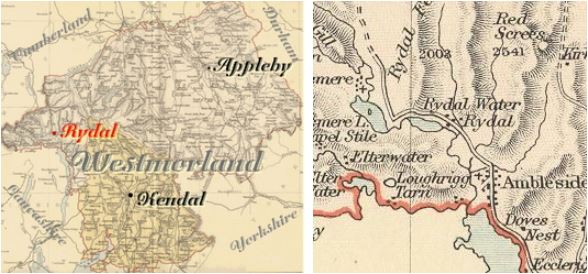
Rydal
hide
Hide
hide
Hide
Hide
Hide
"Rydal, Sir Daniel Fleming supposes to be a contraction of Rowthey-dale, from the river of that name running down there. Loughrigg evidently takes its name from the loughs or lakes with which this country abounds. It is a hamlet of itself, opposite to Rydal on the other side of the water: which being conjoined with a bridge, makes as it were one intire village, yet they are two manors."
[Nicolson & Burn: The history and antiquities of the counties of Westmorland and Cumberland. 1777.]
Hide
Rydal was formerly part of Grasmere parish. It is adjacent to Langdale and Ambleside parishes.
Hide
Returns do not survive for the 'census' of 1787.
Census returns are available from the usual sources for 1841-1911.
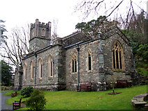
| St Mary, Rydal, Church of England |
| St Mary Simple church of 1824 with W tower, nave and chancel. This and other photographs on Geograph site. Historical and architectural notes on National Heritage List (English Heritage site). Photograph(s) and description on VisitCumbria. Access and contact details on Church of England site |
Parish Registers and Bishop's Transcripts are held by Cumbria Archives :
originals at Kendal RO and microfilm copies at Carlisle RO.
| Baptism registers | 1826-1979 |
| Marriage registers | 1827-1956 |
| Banns registers | - |
| Burial registers | - |
| Bishops transcripts | 1831-1878 |
See the CASCAT online calogue for WPR82 for information on these and other parish records..
For searching on LDS familysearch.org see IGI batch numbers (compiled by Jake Prescott)
or use the batch number search site (by Hugh Wallis).
The details for the parish from the Parson & White's Directory for 1829 are transcribed on Edenlinks site.
- Ask for a calculation of the distance from Rydal to another place.
Records relating to the Barony of Kendale, CWAAS, William Farrer & John F. Curwen (editors) are available on British History Online (also Supplementary Records)
Cumbria County History Trust has published a "Jubilee Digest" for the township of Rydal & Loughrigg
You can see maps centred on OS grid reference NY355075 (Lat/Lon: 54.458462, -2.995711), Rydal which are provided by:
- OpenStreetMap
- Google Maps
- StreetMap (Current Ordnance Survey maps)
- Bing (was Multimap)
- Old Maps Online
- National Library of Scotland (Old Ordnance Survey maps)
- Vision of Britain (Click "Historical units & statistics" for administrative areas.)
- English Jurisdictions in 1851 (Unfortunately the LDS have removed the facility to enable us to specify a starting location, you will need to search yourself on their map.)
- Magic (Geographic information) (Click + on map if it doesn't show)
- GeoHack (Links to on-line maps and location specific services.)
- All places within the same township/parish shown on an Openstreetmap map.
- Nearby townships/parishes shown on an Openstreetmap map.
- Nearby places shown on an Openstreetmap map.
Wills for Rydal will be at Carlisle since about 1858 but before that will be at the Preston R.O.. as it was in the Diocese of Chester until that time.
Hearth Tax records for 1674 Loughrigg & Rydal transcribed on Edenlinks.