
Hide
Beeford
hide
Hide
hide
Hide
Hide
The Ancient Parish of BEEFORD
[Transcribed information mainly from the early 1820s]
"BEEFORD, a parish in the wapentake and liberty of Holderness; 8 miles ESE. of Driffield. A very pleasant village, situated on the high road from Hull to Scarbro'. The church, of which the Rev. W. Welbank Childers, M.A. is rector, is dedicated to St. Leonard (see Churches for photograph), and the King is the patron; here are also two chapels, one of the Independent and the other of the Methodist persuasion; and a free school, conducted on Dr. Bell's plan. Pop. 620.At the time the enclosure of the lands within this township took place, a field containing 11 acres, was laid out, in lieu of certain balks, for the repairs of the church."
"BEEFORD GRANGE, (the seat of Sir George Wood, Knt.) in the township and parish of Beeford; 1 mile N. of Beeford, 10 miles from Great Driffield, 11 from Bridlington."
"CROWGARTH, in the parish of Beeford, wapentake and liberty of Holderness; 7 miles ESE. of Driffield. Pop. included with Beeford."
"DUNNINGTON, in the parish of Beeford, wapentake and liberty of Holderness; 2¾ miles NNE. of Beeford, 7 miles NNW. of Hornsea. Population, 76.
Here was formerly a chapel to Beeford: the foundation is all that at present remains. The chapel yard is still a separate inclosure and a burial ground."
"LISSETT, in the parish of Beeford, wapentake and liberty of Holderness; 2¾ miles NNE. of Beeford, 6 miles SSW. of Bridlington. Here is a small Chapel of Ease (see Churches for photograph), incumbent the Rev. John Mason, curate of Beeford. Pop. 95."
[Description(s) edited mainly from various 19th century sources by Colin Hinson. ©2010]
Hide
- Photographs of the over 450 gravestones and plaques at Beeford church with linked surname index.
- Photographs of the over 75 gravestones and plaques at Lissett church with linked surname index.
- Photographs of the over 30 gravestones and plaques at Dunnington Chapelry with linked surname index.
- Here are photographs of Churches in the parish:
- St Leonard's Church, Beeford (view 1).
- Internal view looking down the nave
- The East Window
- The West Window
- The font
- St Leonard's Church, Beeford (view 2).
- The Church of St James' of Compostella, Lissett.
- St Nicholas' Church, Dunnington (view 1).
- St Nicholas' Church, Dunnington (view 2).
- Internal view looking down the nave
- The East Window
- The font
- Methodist Chapel, Beeford.
- St Leonard's Church, Beeford (view 1).
- Transcript of the entry for Beeford in the "Collections relative to Churches and Chapels".
- Transcript of the entry for Lissett in the "Collections relative to Churches and Chapels".
- A transcript of Beeford Congregational Church History
- The whereabouts and dates of the Registers etc. for the Parish of Beeford.
- The whereabouts and dates of the Registers etc. for the Chapelry of Lissett.
- The List of Rectors of St. Leonard's Church, Beeford.
- Transcript of the entry of "professions and trades" in the Baines's Directory of 1823, of the East Riding.
- Transcript of the entry of "professions and trades" in the The Post Office Directory of the, East and North Ridings, 1857
- Transcript of the entry of "professions and trades" in the Kelly's Directory, for East and North Ridings, 1872
- Transcript of the entry of "professions and trades" in the Bulmers Directory of 1892. of the East Riding.
- There is further information about this parish from the Pigot's 1834 Directory, Yorkshire section.
- There is further information about this parish from the National Gazetteer 1868, Yorkshire extracts.
- There is further information about this parish from the Lewis's Topographical Dictionary of England 1835, Yorkshire extracts.
- There is further information about this parish from the Bulmer's 1892 History and Directory of the East Riding.
- Ask for a calculation of the distance from Beeford to another place.
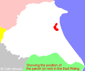
- For a detailed map of this parish see this parish boundaries map.
- For a more detailed map of the parishes in the riding please see the Yorkshire parish maps page.
- For a more detailed map of the county please see the Yorkshire map page.
- Here is a map showing the wapentakes for the county.
You can see maps centred on OS grid reference TA128542 (Lat/Lon: 53.971573, -0.281796), Beeford which are provided by:
- OpenStreetMap
- Google Maps
- StreetMap (Current Ordnance Survey maps)
- Bing (was Multimap)
- Old Maps Online
- National Library of Scotland (Old Ordnance Survey maps)
- Vision of Britain (Click "Historical units & statistics" for administrative areas.)
- English Jurisdictions in 1851 (Unfortunately the LDS have removed the facility to enable us to specify a starting location, you will need to search yourself on their map.)
- Magic (Geographic information) (Click + on map if it doesn't show)
- GeoHack (Links to on-line maps and location specific services.)
- All places within the same township/parish shown on an Openstreetmap map.
- Nearby townships/parishes shown on an Openstreetmap map.
- Nearby places shown on an Openstreetmap map.
- The Roll of Honour in St. Leonard's Church, Beeford.
- The 1914-1918 and 1939-1945 War Memorial.
- Photographs of over 450 gravestones and plaques at Beeford church.
- Photographs of over 75 gravestones and plaques at Lissett church.
- The following places are within the boundaries of this (ancient) parish, but I have no further information on them other than the Ordnance Survey Landranger Grid reference shown:
- (TA140513) Moor Grange
- This parish is covered by the following Society:
- The 1834 Electoral Roll for this parish