
Hide
Kirby Grindalythe
hide
Hide
hide
Hide
Hide
The Ancient Parish of KIRBY GRINDALYTHE
[Transcribed information mainly from the early 1820s]
"KIRBY GRINDALYTHE, a parish in the wapentake of Buckrose, 8 miles ESE. of Malton. The church is dedicated to St Andrew (see Churches for photograph) and the living is a vicarage, in the patronage of Miss Lillingstone, incumbent, Rev. Rowland Croxton. Population 178.This Church was given by Walter Espec, to the Priory of Kirkham."
"DUGGLEBY, in the parish of Kirby Grindalythe, and wapentake of Buckrose; 1¾ miles W. of Kirby Grindalythe, 7 miles SE. of Malton. Pop 154."
"HIGH MOWTHORPE, in the parish of Kirby Grindalythe, and wapentake of Buckrose; 1¼ miles NW. of Kirby Grindalythe, 8 miles SE. of Malton."
"LOW MOWTHORPE, in the parish of Kirby Grindalythe, and wapentake of Buckrose; ¾ mile WSW. of Kirby Grindalythe, 8 miles SE. of Malton."
"THIRKLEBY, in the parish of Kirby Grindalythe, and wapentake of Buckrose; 1¾ miles E. of Kirby Grindalythe, 8 miles E. of Malton. Pop. 44."
[Description(s) edited mainly from various 19th century sources by Colin Hinson. ©2010]
Hide
- Photographs of over 160 gravestones and plaques at Kirby Grindalythe with linked surname index.
- Here are photographs of and in the Church:
- St. Andrew's Church, Kirby Grindalythe (view 1 - sorry about the verticals!).
- Internal view looking down the aisle
- The mosaics on the west wall
- more Mosaic on the walls
- Detail of the same mosaic
- St. Andrew's Church, Kirby Grindalythe (view 2).
- St. Andrew's Church, Kirby Grindalythe (view 1 - sorry about the verticals!).
- Transcript of the entry for Kirby Grindalythe in the "Collections relative to Churches and Chapels".
- The whereabouts and dates of the Registers etc. for the Parish of Kirby Grindalythe.
- The List of Vicars in St. Andrew's, Kirby Grindalythe.
- Transcript of the entry of "professions and trades" in the Baines's Directory of 1823, of the East Riding.
- Transcript of the entry of "professions and trades" in the The Post Office Directory of the, East and North Ridings, 1857
- Transcript of the entry of "professions and trades" in the Bulmers Directory of 1892. of the East Riding.
- There is further information about this parish from the National Gazetteer 1868, Yorkshire extracts.
- There is further information about this parish from the Lewis's Topographical Dictionary of England 1835, Yorkshire extracts.
- There is further information about this parish from the Bulmer's 1892 History and Directory of the East Riding.
- Ask for a calculation of the distance from Kirby Grindalythe to another place.
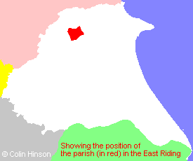
- For a detailed map of this parish see this parish boundaries map.
- For a more detailed map of the parishes in the riding please see the Yorkshire parish maps page.
- For a more detailed map of the county please see the Yorkshire map page.
- Here is a map showing the wapentakes for the county.
You can see maps centred on OS grid reference SE904675 (Lat/Lon: 54.09547, -0.619219), Kirby Grindalythe which are provided by:
- OpenStreetMap
- Google Maps
- StreetMap (Current Ordnance Survey maps)
- Bing (was Multimap)
- Old Maps Online
- National Library of Scotland (Old Ordnance Survey maps)
- Vision of Britain (Click "Historical units & statistics" for administrative areas.)
- English Jurisdictions in 1851 (Unfortunately the LDS have removed the facility to enable us to specify a starting location, you will need to search yourself on their map.)
- Magic (Geographic information) (Click + on map if it doesn't show)
- GeoHack (Links to on-line maps and location specific services.)
- All places within the same township/parish shown on an Openstreetmap map.
- Nearby townships/parishes shown on an Openstreetmap map.
- Nearby places shown on an Openstreetmap map.
- The 1914-18 and 1939-45 Memorial Plaque in Kirby Grindalythe Church.
- The following places are within the boundaries of this (ancient) parish, but I have no further information on them other than the Ordnance Survey Landranger Grid reference shown:
- (SE877688) Duggleby Wold
- (SE903648) Kirby Grange
- (SE872703) South Wold
- (SE918704) Thirkleby Warren House
- (SE921687) Thirkleby Manor
- (SE918704) Thirkleby Wold (was Wold Barn)
- This parish is covered (or partly covered) by the following Societies:
- The 1834 Electoral Roll for this parish