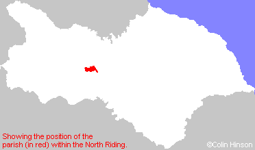
Hide
Hornby
hide
Hide
hide
Hide
Hide
The Ancient Parish of HORNBY
[Transcribed information mainly from the early 1820s]
"HORNBY, a parish in the wapentake of Hang East, and liberties of St. Peter's. and Richmondshire; 5 miles NW. of Bedale. Here is a church dedicated to St. Mary (see Churches for photograph); the living is a vicarage, in the patronage of the Dean and Chapter of York, and the Rev. J. Alderson, is the incumbent. Hornby castle one of the seats of His Grace the Duke of Leeds, is situated in this township. This mansion is a spacious structure of a mixed architecture, and the apartments are grand and superbly finished. The situation is commanding and from the battlements are seen to great advantage the rich and picturesque valley of Bedale, stretching up to the western moors and forming a grand and imposing contrast. Hornby castle was anciently the lordship and seat of the family of St. Quintin, from whom it passed to the Conyers, and ultimately to the Osbornes. Population, 102.""AINDERBY MYERS, in the parish of Hornby, wapentake of Hang East, & liberty of Richmondshire; 4 miles W. of Hornby, 4 miles N. of Bedale. Population including Holtby, 79."
"HACKFORTH, in the parish of Hornby, wapentake of Hang East, and liberties of St. Peter's and Richmondshire; 1¼ miles ESE. of Hornby, 4 miles NNW. of Bedale. Pop. 134.
Here was born about 1474, the celebrated Bishop Tunstall. He as a natural son of a Mr. Tunstall, by a daughter of the Conyers family. He studied at Oxford, Cambridge, and at Padua, where he took the degree of Doctor of laws, and was accounted the best Mathematician of his time. He was consecrated Bishop of London in 1522; and the year following made keeper of the Privy Seal. In 1527 he attended Cardinal Wolsey in his pompous embassy into France; and in 1530 was translated to the bishopric of Durham, of which he was deprived in the reign of Elizabeth, for denying her supremacy; having previously been sent to the tower in 1551, where he continued a prisoner till 1553. He died in the Palace at Lambeth, Nov. 18, 1559, when in the custody of Parker, Archbishop of Canterbury. He wrote "De Arte Sopputandi" Lond. 1522, 4to. and 6 other works. -Gen. Biog. Dict. -Nichols Lit. Anecdotes."
"HIGH HOLTBY, in the parish of Hornby, wapentake of Hang East, & liberty of Richmondshire; 3 miles ESE. of Hornby, 4 miles N. of Bedale, of which Thomas Robson, Esq. is the principal inhabitant. Pop. included with Ainderby Myers."
"ROUND HILL, a farm house in the parish of Hornby, wapentake of Hang East, and liberty of Richmondshire; 3 miles NW. of Bedale."
"STREET HOUSE, a farm house in the township of Ainderby-Myers, and parish of Hornby; 2¼ miles E. of Hornby, 3½ miles from Catterick."
[Description(s) edited mainly from various 19th century sources by Colin Hinson. ©2010]
Hide
- Here is a photograph of St Mary's Church, Hornby.
- Internal view looking down the aisle
- The East Window
- One of the several Darcy monuments
- The font which appears to be 14th century but is actually 18th century
- The holy-water stoup
- Transcript of the entry for Hornby in the "Collections relative to Churches and Chapels".
- The the Belfry Rules in St. Mary's Church, Hornby.
- The whereabouts and dates of the Registers etc. for the Parish of Hornby.
- The list of incumbents in St. Mary's Church, Hornby.
- Transcript of the entry of "professions and trades" in the Baines's Directory of 1823, of the North Riding.
- Transcript of the entry of "professions and trades" in the White's Directory of 1840, Yorkshire section.
- Transcript of the entry of "professions and trades" in the Bulmers Directory of 1890. of the North Riding.
- There is further information about this parish from the National Gazetteer 1868, Yorkshire extracts.
- There is further information about this parish from the Lewis's Topographical Dictionary of England 1835, Yorkshire extracts.
- There is further information about this parish from the Stephen Whatley's Gazetteer 1750, Yorkshire extracts.
- There is further information about this parish from the Bulmer's 1890 History and Directory of the North Riding.
- Ask for a calculation of the distance from Hornby to another place.

- For a detailed map of this parish see this parish boundaries map.
- For a more detailed map of the parishes in the riding please see the Yorkshire parish maps page.
- For a more detailed map of the county please see the Yorkshire map page.
- Here is a map showing the wapentakes for the county.
You can see maps centred on OS grid reference SE223938 (Lat/Lon: 54.339273, -1.658518), Hornby which are provided by:
- OpenStreetMap
- Google Maps
- StreetMap (Current Ordnance Survey maps)
- Bing (was Multimap)
- Old Maps Online
- National Library of Scotland (Old Ordnance Survey maps)
- Vision of Britain (Click "Historical units & statistics" for administrative areas.)
- English Jurisdictions in 1851 (Unfortunately the LDS have removed the facility to enable us to specify a starting location, you will need to search yourself on their map.)
- Magic (Geographic information) (Click + on map if it doesn't show)
- GeoHack (Links to on-line maps and location specific services.)
- All places within the same township/parish shown on an Openstreetmap map.
- Nearby townships/parishes shown on an Openstreetmap map.
- Nearby places shown on an Openstreetmap map.
- The World War I Memorial Plaque on St. Mary's Church, Hornby.
- This parish is covered by the following Society:

