
Hide
Pickering
hide
Hide
hide
Hide
Hide
The Ancient Parish of PICKERING
[Transcribed information mainly from the early 1820s]
"PICKERING, a parish in the wapentake and liberty of Pickering Lythe; 8 miles from Kirkbymoorside; 9 from Malton; and 18 from Scarbro'. Market Monday, Fairs, Monday before February 14, Monday before May 13, September 25, Monday before November 23, for horned cattle horses, sheep, and pigs. Principal Inns, Black Swan, and White Swan." (There is further information for Pickering).Information on the following places in this Parish is contained on a supplementary page.
|
|
[Description(s) edited mainly from various 19th century sources by Colin Hinson. ©2010]
Hide
- Photographs of over 150 gravestones in Newton on Rawcliffe Cemetery with linked surname index.
- Photographs of over 150 gravestones in Newton on Rawcliffe Graveyard with linked surname index.
- Here are photographs of Churches in the parish:
- St Peter and St. Paul's Church, Pickering.
- Internal view looking down the nave
- St Peter and St. Paul's Church, Pickering from an old photograph with less trees in the way.
- The Primitive Methodist Church, Pickering, founded in 1855. (The Church's website is here.)
- St. Joseph's Roman Catholic Church, Pickering. (The Church's website is here.)
- The United Reformed Church, Pickering.
- Pickering Carr Methodist Chapel, Pickering Carr.
- St. John's Church, Newton on Rawcliffe.
- The Methodist Church, Newton on Rawcliffe.
- St. Mary's Church, Goathland, view 1. (The Church's website is here.)
- Internal view looking down the aisle
- The East Window
- The font
- St. Mary's Church, Goathland, view 2.
- The C of E Chapel at Low Marishes, Low Marishes.
- St Peter and St. Paul's Church, Pickering.
- There is a history and photographs for St. Mary's, Goathland on the Mid Esk Benenfice website.
- A transcript of Pickering Congregational Church History
- Transcript of the entry for Pickering in the "Collections relative to Churches and Chapels".
- Transcript of the entry for Goathland in the "Collections relative to Churches and Chapels".
- Transcript of the entry for Newton in the "Collections relative to Churches and Chapels".
- The whereabouts and dates of the Registers etc. for the Chapelry of Goathland.
- The whereabouts and dates of the Registers etc. for the Parish of Pickering.
- The List of Vicars in St. Peter and St. Paul's Church, Pickering.
- Transcript of the entry of "professions and trades" in the Baines's Directory of 1823, of the North Riding.
- Transcript of the entry of "professions and trades" in the Pigot's 1829 Directory, Yorkshire section.
- Transcript of the entry of "professions and trades" in the Pigot's 1834 Directory, Yorkshire section.
- Transcript of the entry of "professions and trades" in the White's Directory of 1840, Yorkshire section.
- Transcript of the entry of "professions and trades" in the Bulmers Directory of 1890. of the North Riding.
- There is further information about this parish from the Pigot's 1829 Directory, Yorkshire section.
- There is further information about this parish from the Pigot's 1834 Directory, Yorkshire section.
- There is further information about this parish from the National Gazetteer 1868, Yorkshire extracts.
- There is further information about this parish from the Lewis's Topographical Dictionary of England 1835, Yorkshire extracts.
- There is further information about this parish from the Stephen Whatley's Gazetteer 1750, Yorkshire extracts.
- There is further information about this parish from the Bulmer's 1890 History and Directory of the North Riding.
- Ask for a calculation of the distance from Pickering to another place.
- Between 1834 and 1890 the township of Goathland (in this parish) became a parish in its own right. See Goathland Parish.
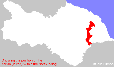
- For a detailed map of this parish see this parish boundaries map.
- For a more detailed map of the parishes in the riding please see the Yorkshire parish maps page.
- For a more detailed map of the county please see the Yorkshire map page.
- Here is a map showing the wapentakes for the county.
You can see maps centred on OS grid reference SE799838 (Lat/Lon: 54.243665, -0.77541), Pickering which are provided by:
- OpenStreetMap
- Google Maps
- StreetMap (Current Ordnance Survey maps)
- Bing (was Multimap)
- Old Maps Online
- National Library of Scotland (Old Ordnance Survey maps)
- Vision of Britain (Click "Historical units & statistics" for administrative areas.)
- English Jurisdictions in 1851 (Unfortunately the LDS have removed the facility to enable us to specify a starting location, you will need to search yourself on their map.)
- Magic (Geographic information) (Click + on map if it doesn't show)
- GeoHack (Links to on-line maps and location specific services.)
- All places within the same township/parish shown on an Openstreetmap map.
- Nearby townships/parishes shown on an Openstreetmap map.
- Nearby places shown on an Openstreetmap map.
- The 1914 to 1918 War Memorial Plaque in St. Peter and St. Paul's Church, Pickering.
- The 1939 to 1945 War Memorial Plaque in St. Peter and St. Paul's Church, Pickering.
- The World War I Memorial Plaque in St. Mary's Church, Goathland.
- The World War II Memorial Plaque in St. Mary's Church, Goathland.
- The following places are within the boundaries of this (ancient) parish, but I have no further information on them other than the Ordnance Survey Landranger Grid reference shown:
- (SE805940) Raindale
- Minute Books of the Pickering Board of Guardians. These contain a very large number of names and are split into lists of alphabetical surnames.
- Carol Bartlett has transcribed the Pickering Union Workhouse Admission & Discharge Books and an index of names.
- This parish is covered (or partly covered) by the following Societies: