Hide
Wath
hide
Hide
hide
Hide
Hide
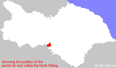
The Ancient Parish of WATH
[Transcribed information mainly from the early 1820s]
"WATH, a parish in the wapentake of Halikeld, and liberty of Richmondshire; 4 miles N. of Ripon. The church is dedicated to St. Mary (see Churches for photograph); the living is a rectory, in the patronage of the Marquis of Ailesbury, and the Rev. Benjamin Newton, A. M. is the incumbent. This village derives its name from its situation, there being a rivulet at each end of it, which the villagers were formerly obliged to wade or ford. There is now a good stone bridge over each. Pop. 186.Here is a school founded in 1690, by Dr. Peter Samwaise, who endowed it with lands at Bellerby, value 70L. per annum. Five pounds per annum is also paid to the master by Trinity College, Cambridge, out of an estate at Middleton-Quernhow; this college also pays a donation of 10L. per annum. Here is also an alms house, built 1698, and endowed by the above Peter Samwaise, containing rooms for two poor persons, who receive 2L. 14s. per annum, the interest of 60L."
"MELMERBY, in the parish of Wath, wapentake of Halikeld, and liberty of Richmondshire; ¾ mile ESE. of Wath, 5 miles NNE. of Ripon. Population, 258."
"MIDDLETON QUERNHOW, in the parish of Wath, wapentake of Halikeld, and liberty of Richmondshire; 1 mile NE. of Wath, 5 miles N. of Ripon. Pop. 102."
"NORTON CONYERS, in the parish of Wath, wapentake and liberty of Allertonshire; ¾ mile SSW. of Wath, 3 miles N. of Ripon. This was once the seat of the family of the Nortons; of whom Richard Norton was Chief Justice of England, about the year 1400: from him descended Richard Norton, who, with his sons, in 1569, engaged in the religious rebellion of the Earls of Northumberland and Westmoreland, against Queen Elizabeth, which was soon suppressed. Mr. Norton, and his sons, with many others, were executed, and the estate given to the Musgraves." (There is further information for Norton Conyers).
"YORK GATE INN, in the parish of Wath, wapentake of Halikeld, and liberty of Richmondshire; 1½ miles E. of Wath, 5 miles NNE. of Ripon. The Magistrates for the wapentake hold their meetings here, and at the New-Inn, alternately."
[Description(s) edited mainly from various 19th century sources by Colin Hinson. ©2010]
Hide
- Please see Christine Amsden's Census pages for the following Census transcriptions:
- Melmerby: 1841, 1851, 1891, 1901
- Here are photographs of Churches etc. in the parish:
- St. Mary's Church, Wath.
- Internal view looking down the nave
- The East Window
- The font inside the church
- The font outside the church
- The Methodist Church, Melmerby.
- St. Mary's Church, Wath.
- Transcript of the entry for Wath in the "Collections relative to Churches and Chapels".
- The whereabouts and dates of the Registers etc. for the Parish of Wath.
- The list of Incumbents in St. Mary's Church, Wath.
- Transcript of the entry of "professions and trades" in the Baines's Directory of 1823, of the North Riding.
- Transcript of the entry of "professions and trades" in the White's Directory of 1840, Yorkshire section.
- Transcript of the entry of "professions and trades" in the Bulmers Directory of 1890. of the North Riding.
- There is further information about this parish from the National Gazetteer 1868, Yorkshire extracts.
- There is further information about this parish from the Lewis's Topographical Dictionary of England 1835, Yorkshire extracts.
- There is further information about this parish from the Bulmer's 1890 History and Directory of the North Riding.
- Ask for a calculation of the distance from Wath to another place.

- For a detailed map of this parish see this parish boundaries map.
- For a more detailed map of the parishes in the riding please see the Yorkshire parish maps page.
- For a more detailed map of the county please see the Yorkshire map page.
- Here is a map showing the wapentakes for the county.
You can see maps centred on OS grid reference SE324772 (Lat/Lon: 54.189551, -1.504969), Wath which are provided by:
- OpenStreetMap
- Google Maps
- StreetMap (Current Ordnance Survey maps)
- Bing (was Multimap)
- Old Maps Online
- National Library of Scotland (Old Ordnance Survey maps)
- Vision of Britain (Click "Historical units & statistics" for administrative areas.)
- English Jurisdictions in 1851 (Unfortunately the LDS have removed the facility to enable us to specify a starting location, you will need to search yourself on their map.)
- Magic (Geographic information) (Click + on map if it doesn't show)
- GeoHack (Links to on-line maps and location specific services.)
- All places within the same township/parish shown on an Openstreetmap map.
- Nearby townships/parishes shown on an Openstreetmap map.
- Nearby places shown on an Openstreetmap map.
- The World War I and II Memorial Plaques in St. Mary's Church, Wath.
- The World War I Roll of Honour in St. Mary's Church porch, Wath.
- This parish is covered by the following Society:

