Hide
Bolton By Bowland
hide
Hide
hide
Hide
Hide
The Ancient Parish of BOLTON BY BOWLAND
[Transcribed information mainly from the early 1820s]
"BOLTON BY BOWLAND, a parish-town, in the west-division and liberty of Staincliffe; (Bolton Hall, the occasional residence of John Bolton, Esq.) 4 miles W. of Gisburn, 10 from Settle, 12 from Colne, (Lanc.) 14 from Skipton, 55 from York. No Market. Fairs, June 28, 29, and 30, or horned cattle, pedlary, &c. Pop. 1,205. The Church is a rectory, dedicated to St. Peter, in the deanry of Craven, value, £11. 13s. 4d. p.r. £123. 12s. Patron, John Bolton, Esq.Bolton Hall the ancient residence of the family of Pudsay, says, Dodsworth, "stands very pleasantly among sweet woods and fruitful hills." Here Sir Ralph Pudsay sheltered his persecuted sovereign Henry VI. after the battle of Hexham: and where still are preserved a pair of boots, a pair of gloves, and a spoon, which the unfortunate Monarch left, either from haste and trepidation, or as tokens of regard for the family. An adjoining Well still retains the name of "King Harry," who is said to have directed it to be dug and walled, in its present shape, for a cold bath. In the church, which is a plain building of late Gothic architecture, is the famous monument of Sir Ralph Pudsay, with his three wives and twenty five children, all engraven in relief, upon a slab of grey Craven limestone. --Whitaker's Craven. The manor and advowson were purchased for £42,000. by John Bolton, of Liverpool, Esq. its present owner."
"HOLDEN, in the township and parish of Bolton by Bowland, liberty of Staincliffe; 5 miles from Guisburn, 10 from Settle, 13 from Skipton,"
"HUNGRILL, a farm-house in the township and parish of Bolton by Bowland, liberty of Staincliffe; 5 miles from Gisburn, 10 miles S. of Settle.
This was, for many generations, the residence of the Walkers; and now of Edward King, Esq., Vice Chancellor of the duchy of Lancaster."
"MONUBENT, a farm-house in the township of Gisburn Forest, and parish of Bolton by Bowland, liberty of Staincliffe; 6 miles from Gisburn, 9 from Settle."
"SKIRDEN, a farm-house in the township and parish of Bolton by Bowland, liberty of Staincliffe; 4½ miles from Gisburn, 9 miles SSW. of Settle."
[Description(s) edited from various 19th century sources by Colin Hinson © 2013]
Hide
- Here is a photograph of St. Peter and St. Paul's Church, Bolton by Bowland.
- Internal view looking down the nave
- A transcription of the Holden Congregational Church History
- Transcript of the entry for Bolton by Bowland in the "Collections relative to Churches and Chapels".
- Craig Thornber has transcribed the records for Holden Chapel.
- The whereabouts and dates of the Registers etc. for the Parish of Bolton by Bowland.
- The list of Rectors for the parish.
- Transcript of the entry of "professions and trades" in the Baines's Directory and Gazetteer, Vol I, West Riding.
- There is further information about this parish from the National Gazetteer 1868, Yorkshire extracts.
- There is further information about this parish from the Lewis's Topographical Dictionary of England, Yorkshire extracts.
- There is further information about this parish from the Stephen Whatley's Gazetteer 1750, Yorkshire extracts.
- Ask for a calculation of the distance from Bolton By Bowland to another place.
- A transcription of the Holden Congregational Church History

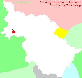
- For a detailed map of this parish see this parish boundaries map.
- For a more detailed map of the parishes in the riding please see the Yorkshire parish maps page.
- For a more detailed map of the county please see the Yorkshire map page.
- Here is a map showing the wapentakes for the county.
You can see maps centred on OS grid reference SD787495 (Lat/Lon: 53.941168, -2.325966), Bolton By Bowland which are provided by:
- OpenStreetMap
- Google Maps
- StreetMap (Current Ordnance Survey maps)
- Bing (was Multimap)
- Old Maps Online
- National Library of Scotland (Old Ordnance Survey maps)
- Vision of Britain (Click "Historical units & statistics" for administrative areas.)
- English Jurisdictions in 1851 (Unfortunately the LDS have removed the facility to enable us to specify a starting location, you will need to search yourself on their map.)
- Magic (Geographic information) (Click + on map if it doesn't show)
- GeoHack (Links to on-line maps and location specific services.)
- All places within the same township/parish shown on an Openstreetmap map.
- Nearby townships/parishes shown on an Openstreetmap map.
- Nearby places shown on an Openstreetmap map.
- The war memorial to those who fell in the two world wars.
- The memorial plaque in the church to those who fell in the 1914-18 war.
- This parish is covered by the following Society:
- A list of those paying the 1379 Subsidy Rolls (Poll Tax) for this parish.

