
Hide
Drax
hide
Hide
hide
Hide
Hide
The Ancient Parish of DRAX
[Transcribed information mainly from the early 1820s]
"DRAX, a parish-town, in the wapentake of Barkston-Ash; 4 miles N. of Snaith, 7 from Selby, 14 from Pontefract, 22 from York. Pop. 370. The Church is a vicarage, dedicated to St. Peter (see Churches for photograph), in the deanry of the Ainsty, value, ~£4. p.r. !£88. Patron, the King.The Free Grammar School at Drax was founded in 1667, by Charles Read, Gentleman, of Darleton, in the county of Nottingham, who was born in this parish. He erected a school House and dwelling for a master, as also six alms Houses, in the town and parish of Drax; and designed the same school House for a free school and a master for ever, to teach the youth of the parish to read write, accompt, and also Latin, Greek, and Hebrew. The original endowment was £30. per annum to the master, which yet remains the same, but an advance of salary is expected to take place. "If any of the boys he deemed fit for the University, they shall be sent to either Cambridge or Oxford." --Carlisles Gram. Schools."
Information on the following places in this Parish is contained on a supplementary page.
|
|
|
[Description(s) edited from various 19th century sources by Colin Hinson © 2013]
Hide
- Here are photographs of Churches etc. in the parish:
- St Peter and St Paul's Church, Drax.
- The Village Church, Camblesforth, ex Wesleyan, founded in 1894.
- Transcript of the entry for Drax in the "Collections relative to Churches and Chapels".
- The whereabouts and dates of the Registers etc. for the Parish of Drax.
- Transcript of the entry of "professions and trades" in the Baines's Directory and Gazetteer, Vol I, West Riding.
- There is further information about this parish from the National Gazetteer 1868, Yorkshire extracts.
- There is further information about this parish from the Lewis's Topographical Dictionary of England, Yorkshire extracts.
- There is further information about this parish from the Stephen Whatley's Gazetteer 1750, Yorkshire extracts.
- Ask for a calculation of the distance from Drax to another place.
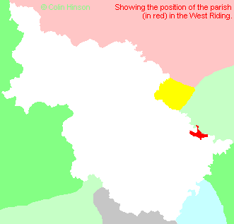
- For a detailed map of this parish see this parish boundaries map.
- For a more detailed map of the parishes in the riding please see the Yorkshire parish maps page.
- For a more detailed map of the county please see the Yorkshire map page.
- Here is a map showing the wapentakes for the county.
You can see maps centred on OS grid reference SE676264 (Lat/Lon: 53.729626, -0.97684), Drax which are provided by:
- OpenStreetMap
- Google Maps
- StreetMap (Current Ordnance Survey maps)
- Bing (was Multimap)
- Old Maps Online
- National Library of Scotland (Old Ordnance Survey maps)
- Vision of Britain (Click "Historical units & statistics" for administrative areas.)
- English Jurisdictions in 1851 (Unfortunately the LDS have removed the facility to enable us to specify a starting location, you will need to search yourself on their map.)
- Magic (Geographic information) (Click + on map if it doesn't show)
- GeoHack (Links to on-line maps and location specific services.)
- All places within the same township/parish shown on an Openstreetmap map.
- Nearby townships/parishes shown on an Openstreetmap map.
- Nearby places shown on an Openstreetmap map.
- The following places are within the boundaries of this (ancient) parish, but I have no further information on them other than the Ordnance Survey Landranger Grid reference shown:
- (SE693266) Rusholme Hall
- (SE702266) Rusholme Grange
- This parish is covered by the following Society:
- A list of those paying the 1379 Subsidy Rolls (Poll Tax) for this parish.