
Hide
Kirkby Wharfe
hide
Hide
hide
Hide
Hide
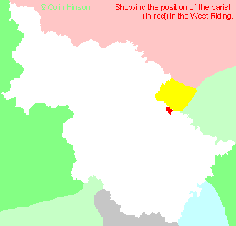
The Ancient Parish of KIRKBY WHARFE
[Transcribed information mainly from the early 1820s]
"KIRKBY WHARFE, a parish-town, in the wapentake of Barkston Ash, liberties of St. Peter and Pontefract; 2 miles S. of Tadcaster, 12 from York and Selby, 13 from Pontefract. Pop. including Milford, 86. The Church is a vicarage, dedicated to St. John the Baptist (see Churches for photograph), in the deanry of the Ainsty, value, ~£3. 16s. 8d. p.r. £120. Patron, the Prebendary of Wetwang.""GRIMSTON, in the parish of Kirkby Wharfe, wapentake of Barkston-Ash, liberty of Pontefract; (Grimston Hall, the seat of Lord Howden,) 1½ miles S. of Tadcaster, 11½ from Ferrybridge, 13 from Pontefract. Pop. 62.
Sir John Francis Cradock, of Grimston Hall, was created a Baron of Ireland by the title of Baron Howden, of Grimston and Spaldington, in this county, and of Cradocks Town, in the county of Kildare, October 19, 1819. His Lordship's family is of ancient Welsh origin, claiming descent from Carodoc, and the ancient Princes of Wales; the name properly Carodoc. His lordship's father, John Cradock, was Archbishop of Dublin, and died in 1778. Heir apparent, John Hobart, only son. --Debrett."
"NORTH MILFORD, (or North Milforth) a hamlet in the parish of Kirkby Wharfe, wapentake of Barkston Ash, and honour of Pontefract; 3 miles S. of Tadcaster."
[Description(s) edited from various 19th century sources by Colin Hinson © 2013]
Hide
- A complete set of Monumental inscriptions for the churchyard and the extension at St. John's, Kirkby Wharfe, has been produced by John Price of Louisiana
- Here are photographs of Churches etc. in the parish:
- St. John the Baptist's Church, Kirkby Wharfe (view 1).
- St. John the Baptist's Church, Kirkby Wharfe (view 2).
- Internal view looking down the nave
- The East Window
- The font
- Transcript of the entry for Kirkby Wharfe in the "Collections relative to Churches and Chapels".
- The List of Vicars in St. John's , Kirkby Wharfe.
- The whereabouts and dates of the Registers etc. for the Parish of Kirkby Wharfe.
- Transcript of the entry of "professions and trades" in the Baines's Directory and Gazetteer, Vol I, West Riding.
- There is further information about this parish from the National Gazetteer 1868, Yorkshire extracts.
- There is further information about this parish from the Lewis's Topographical Dictionary of England, Yorkshire extracts.
- Ask for a calculation of the distance from Kirkby Wharfe to another place.
- For a detailed map of this parish see this parish boundaries map.
- For a more detailed map of the parishes in the riding please see the Yorkshire parish maps page.
- For a more detailed map of the county please see the Yorkshire map page.
- Here is a map showing the wapentakes for the county.
You can see maps centred on OS grid reference SE507408 (Lat/Lon: 53.860953, -1.230606), Kirkby Wharfe which are provided by:
- OpenStreetMap
- Google Maps
- StreetMap (Current Ordnance Survey maps)
- Bing (was Multimap)
- Old Maps Online
- National Library of Scotland (Old Ordnance Survey maps)
- Vision of Britain (Click "Historical units & statistics" for administrative areas.)
- English Jurisdictions in 1851 (Unfortunately the LDS have removed the facility to enable us to specify a starting location, you will need to search yourself on their map.)
- Magic (Geographic information) (Click + on map if it doesn't show)
- GeoHack (Links to on-line maps and location specific services.)
- All places within the same township/parish shown on an Openstreetmap map.
- Nearby townships/parishes shown on an Openstreetmap map.
- Nearby places shown on an Openstreetmap map.
- The World War I and II Memorial Plaque in St. John's Church, Kirkby Wharfe.
- This parish is covered by the following Society:
- A list of those paying the 1379 Subsidy Rolls (Poll Tax) for this parish.