
Hide
Wath Upon Dearne
hide
Hide
hide
Hide
hide
Hide
Hide
The Ancient Parish of WATH UPON DEARNE
[Transcribed information mainly from the early 1820s]
"WATH UPON DEARNE, a parish-town, in the upper division of Strafforth and Tickhill, liberty of Tickhill; 6 miles N. of Rotherham, 9 from Doncaster, 11 from Sheffield, 45 from York. Pop. 1,001. The Church is a vicarage, dedicated to All-Saints (see Churches for photograph), in the deanry of Doncaster, value, ~£15. 10s. 2½d. Patrons, the Dean and Cannons of Christ Church, Oxford.Here is a National School, founded by the Trustees of Mrs. Ellis's charity, in 1819."
Information on the following places in this Parish is contained on a supplementary page.
|
|
|
[Description(s) edited from various 19th century sources by Colin Hinson © 2013]
Hide
- A transcription of the Plaques and MIs in/at All Saints Church, Wath upon Dearne.
- Under the FreeCen project, a part of the 1891 Census has been transcribed for a part of this parish.
- The first List of Benefactions in All Saints Church, Wath upon Dearne.
- The second List of Benefactions in All Saints Church, Wath upon Dearne.
- Here are photographs of:
- The churches in Wath upon Dearne, Wentworth and Swinton.
- The Churches in the rest of the Ancient Parish of Wath upon Dearne
- Edward Wilkinson has written a Short History of St. John's Methodist Church, Elsecar, South Yorkshire.
- A transcription of the Stubbin Elsecar Congregational Church History
- A transcription of the Swinton Congregational Church History
- A transcription of the West Melton Congregational Church History
- Transcript of the entry for Wath upon Dearne in the "Collections relative to Churches and Chapels".
- Transcript of the entry for Hoyland Juxta Wath in the "Collections relative to Churches and Chapels".
- Transcript of the entry for Swinton in the "Collections relative to Churches and Chapels".
- Transcript of the entry for Wentworth in the "Collections relative to Churches and Chapels".
- The following transcriptions are transcriptions of transcriptions originally done in 1988 by Wath and Mexborough Archives. These documents have many typographical errors and so we cannot vouch for the accuracy in the original transcription. If you find anything of interest here, please be sure to check the original Parish Registers source material.
Transcriptions by Jack Parry of:- The transcripts of Wath upon Dearne Baptism Registers for:
- 1598-1619, 1620-1629, 1630-1639, 1640-1649, 1650-1659, 1660-1669, 1670-1679, 1680-1689,
- 1690-1699, 1700-1709, 1710-1719, 1720-1739, 1740-1749, 1750-1759, 1760-1769, 1770-1779,
- 1780-1789, 1790-1799, 1800-1809, 1810-1819, 1820-1829, 1830-1839, 1840-1844, 1845-1849,
- 1850-1854, 1855-1859, 1860-1864, 1865-1869, 1870-1874, 1875-1879, 1880-1884, 1885-1889,
- 1890-1894, 1895-1899, 1900-1903.
- The transcripts of Wath upon Dearne Marriage Registers for:
- The transcripts of Wath upon Dearne Burial Registers for:
- 1598-1619, 1620-1629, 1630-1639, 1640-1649, 1650-1659, 1660-1669, 1670-1679, 1680-1689,
- 1690-1699, 1700-1709, 1710-1719, 1720-1729, 1730-1739, 1740-1749, 1750-1759, 1760-1769,
- 1770-1778, 1770-1779, 1780-1789, 1790-1799, 1800-1809, 1810-1819, 1820-1829, 1830-1839,
- 1840-1849. 1850-1859, 1860-1869, 1870-1879, 1880-1889.
- The transcripts of Swinton Baptism Registers for:
- The transcripts of Swinton Burial Registers for:
- The transcripts of Wentworth Baptism Registers for:
- 1654-1669, 1670-1679, 1680-1689, 1690-1699, 1700-1709, 1710-1729, 1730-1739, 1740-1749,
- 1750-1759, 1760-1769, 1770-1779, 1780-1784, 1785-1789, 1790-1794, 1795-1799, 1800-1804,
- 1805-1809, 1810-1814, 1815-1819, 1820-1824, 1825-1829, 1830-1834, 1835-1838, 1839-1842,
- 1843-1849, 1850-1859, 1860-1869, 1870-1879.
- The transcripts of Wentworth Marriage Registers for:
- The transcripts of Wentworth Burial Registers for:
- The transcripts of Swinton Bridge Methodist Baptism Registers for:
- The transcripts of Swinton St. John Methodist Baptism Registers for:
- The transcripts of Hoober Methodist Baptism Registers for:
- The transcripts of Piccadilly (Swinton) Methodist Baptism Registers for:
- The transcripts of Wath upon Dearne Baptism Registers for:
- The whereabouts and dates of the Registers etc. for the Parish of Wath upon Dearne.
- The whereabouts and dates of the Registers etc. for the Chapelry of Nether Hoyland.
- The whereabouts and dates of the Registers etc. for the Chapelry of Swinton.
- The whereabouts and dates of the Registers etc. for the Chapelry of Wentworth.
- The List of Incumbents in All Saints Church, Wath upon Dearne.
- Wentworth Woodhouse was built for Thomas Wentworth (who became the first Marquis of Rockingham) in the second quarter of the 18th century. Here is a close up photograph of the house.
- Transcript of the entry of "professions and trades" in the Baines's Directory and Gazetteer, Vol I, West Riding.
- Transcript of the entry of "professions and trades" in the Pigot's 1834 Directory, Yorkshire section.
- There is further information about this parish from the Pigot's 1834 Directory, Yorkshire section.
- There is further information about this parish from the National Gazetteer 1868, Yorkshire extracts.
- There is further information about this parish from the Lewis's Topographical Dictionary of England, Yorkshire extracts.
- There is further information about this parish from the Stephen Whatley's Gazetteer 1750, Yorkshire extracts.
- Ask for a calculation of the distance from Wath Upon Dearne to another place.
- Edward Wilkinson has written a short article about the villages of Newhill, Hoyland Common and Platt's Common.
- A transcription of the Stubbin Elsecar Congregational Church History
- A transcription of the Swinton Congregational Church History
- A transcription of the West Melton Congregational Church History
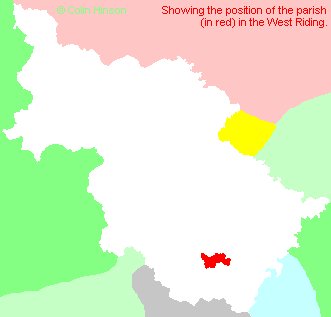
- For a detailed map of this parish see this parish boundaries map.
- For a more detailed map of the parishes in the riding please see the Yorkshire parish maps page.
- For a more detailed map of the county please see the Yorkshire map page.
- Here is a map showing the wapentakes for the county.
You can see maps centred on OS grid reference SE436002 (Lat/Lon: 53.496702, -1.344241), Wath Upon Dearne which are provided by:
- OpenStreetMap
- Google Maps
- StreetMap (Current Ordnance Survey maps)
- Bing (was Multimap)
- Old Maps Online
- National Library of Scotland (Old Ordnance Survey maps)
- Vision of Britain (Click "Historical units & statistics" for administrative areas.)
- English Jurisdictions in 1851 (Unfortunately the LDS have removed the facility to enable us to specify a starting location, you will need to search yourself on their map.)
- Magic (Geographic information) (Click + on map if it doesn't show)
- GeoHack (Links to on-line maps and location specific services.)
- All places within the same township/parish shown on an Openstreetmap map.
- Nearby townships/parishes shown on an Openstreetmap map.
- Nearby places shown on an Openstreetmap map.
- The 1939-1945 War Memorial at All Saints, Wath upon Dearne.
- The World War I Memorial Plaque in Holy Trinity Church, Wentworth.
- The World War I Memorial Plaque to the men of Wath Main Colliery, in All Saints Church, Wath upon Dearne.
- The World War I Memorial Plaque in All Saints Church, Wath upon Dearne.
- The First World War memorial in All Saints Churchyard, Wath upon Dearne
- The following places are within the boundaries of this (ancient) parish, but I have no further information on them other than the Ordnance Survey Landranger Grid reference shown:
- (SK365977) Hood Hill
- This parish is covered (or partly covered) by the following Societies:
- A list of those paying the 1379 Subsidy Rolls (Poll Tax) for this parish.