
Hide
Kinawley Parish
hide
Hide
hide
Hide
hide
Hide
Hide
"Kinawley, a parish, partly in the barony of Tullaghagh county of Cavan, partly in that of Glenawley, but chiefly in that of Knockninny County of Fermanagh, and province of Ulster, 6 miles from Ballyconnell, on the road to Enniskillen ; containing, with the post-town of Swanlinbar, which is separately described, 16,077 inhabitants. According to the Ordnance survey it comprises 51,004 statute acres, of which 15,346 are in the county of Cavan; and, including islands, 35,657 are in the county of Fermanagh; of the latter number, 2895 acres are in Upper Lough Erne, and 645 in small loughs. Agriculture is in a good state; there is a considerable quantity of bog, and limestone and freestone are abundant. Cuilcagh mountain, which, according to the Ordnance survey, is 2188 feet high, is in the Cavan part of the parish."
[From Lewis' Topographical Dictionary of Ireland (1837)]
Hide
- Cunningham, T. P. "The 1766 Religous Census, Kilmore and Ardagh", Breifne, Vol. 1, No. 4 (1962) p. 357-362
- See also LDS Film 100173.
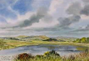
Derryallen Lough, Kinawley, Co. Fermanagh
From the collection Pictures of Great Britain & Ireland, by Martin Goode.
Reproduced here with permission Martin Goode Watercolours
The transcription for this parish from the National Gazetteer (1868), provided by Colin Hinson.
- Ask for a calculation of the distance from Kinawley Parish to another place.
You can see maps centred on OSI grid reference H1573325929 (Lat/Lon: 54.182134, -7.759784), Kinawley Parish which are provided by:
- OpenStreetMap
- Google Maps
- Bing (was Multimap)
- Copy
Kinawley Parishand paste it along with the county name into the search box at Ordnance Survey Ireland. - GeoHack (Links to on-line maps and location specific services.)
- All places within the same township/parish shown on an Openstreetmap map.
- Nearby townships/parishes shown on an Openstreetmap map.
- Nearby places shown on an Openstreetmap map.